This small town in northwest Wales has the country’s largest medieval castle and surrounding wall, both UNESCO World Heritage Sites. Come see where English royalty becomes the Prince of Wales before being crowned the monarch of the United Kingdom.
This small town in northwest Wales has the country’s largest medieval castle and surrounding wall, both UNESCO World Heritage Sites. Come see where English royalty becomes the Prince of Wales before being crowned the monarch of the United Kingdom.
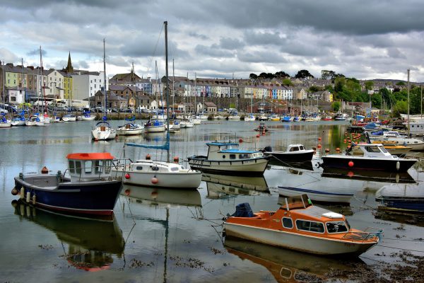
Caernarfon is a small town of about 10,000 residents in northwestern Wales. Segontium Roman fort was established here in 80 AD. This was a logical location because of the natural harbor formed as the Afon Seiont river empties into the Menai Strait. The Victorian Dock was built in the 1860s to accommodate imports from Scandinavia. Now, the marina caters to small watercraft of local Cofis and modern-day explorers of Wale’s coastline. Most tourists arrive by highway A487. They come to see the castle. They stay to enjoy the town’s quiet charm.
Castle Marine Ltd The Harbour, Caernarfon LL54 5RS, UK Enlarge/Slideshow See On Map Directions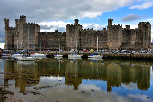
Edward I was the King of England from 1272 until 1307. In December of 1282, his English troops defeated a Welsh rebellion and severed the head of the Prince of Wales, Llwelyn ap Gruffudd. Then Edward ordered a massive fortress be built to defend against future attacks in Caernarfonshire. However, it was reclaimed by Madog ap Llywelyn after he sacked the town in 1294. The following year, King Edward regained control and construction continued through 1330 (it was never finished). Towards the late 15th century, its strategic importance diminished and its condition languished. The features shown on this southern profile are (l to r): the Eagle Tower, Queen’s Tower, Chamberlain Tower, Black Tower, Cistern Tower and the Queen’s Gate. In the foreground is the small boat harbor of Afon Seiont, a tidal river flowing along the edge of this medieval town. Notice how mud flats appear at low tide.
Caernarfon Castle Castle Ditch, Caernarfon LL55 2AY, UK Enlarge/Slideshow See On Map Directions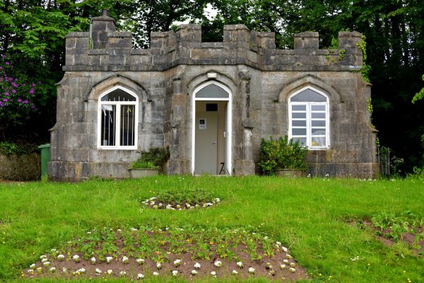
This bridge keeper’s lodge is the first thing you encounter after crossing the Aber Swing Bridge from Caernarfon’s center. The Aber Ferry House was constructed in 1822. From there, one direction along the Aber Foreshore Road provides a panorama of the castle and the quaint town buildings on the north bank of the River Seiont. Take the walkway in the other direction for outstanding views of the Menai Strait and to reach the Coed Helen Recreational Park.
Pont Yr Aber Caernarfon, UK Enlarge/Slideshow See On Map Directions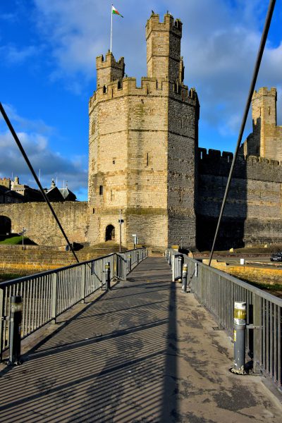
The Pont Yr Aber is a pedestrian bridge connecting the north and south banks of the River Seiont. An operator swings it open to allow boats to enter the harbor. A previous version of the footbridge was here in 1900. This replacement was built in 1970. In 2015, the Gwynedd Council announced its plan to close the landmark as part of an austerity effort. The news sparked major protests and a petition generating over 25,000 signatures. In the background is Eagle Tower, part of the Caernarfon Castle.
Pont Yr Aber Caernarfon, UK Enlarge/Slideshow See On Map Directions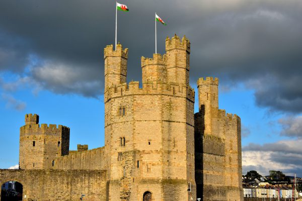
This view of the 13th century Caernarfon Castle from near the Aber Swing Bridge on the south bank of Afon Seiont provides a panorama of the western defenses. Let’s start on the left and look right. The arched opening is Water Gate leading from the quay to Castle Ditch Street. Behind it is the Well Tower. In the foreground is Eagle Tower and next to it is Queen’s Tower. These are three of a dozen towers encircling Caernarfon Castle. This UNESCO World Heritage Site, spelled Caernarvon in English, is one of the most popular tourist attractions in Wales. The warm hue of the façade is courtesy of a wonderful sunset.
Caernarfon Castle Castle Ditch, Caernarfon LL55 2AY, UK Enlarge/Slideshow See On Map Directions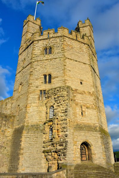
Eagle Tower is the largest and most impressive element of Caernarfon Castle. You might notice the carvings of eagles decorating the battlements. Its ten-sided design measures 33 feet at the base. It was the first structure to be built, intended to repel attacks by sea until the rest of the stronghold could be finished. Look closely at the area of rough stone. This was the foundation of a water gate that was never constructed. The steps leading to the arched doorway was used to accept ship deliveries.
Caernarfon Castle Castle Ditch, Caernarfon LL55 2AY, UK Enlarge/Slideshow See On Map Directions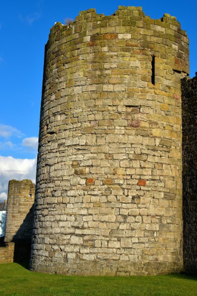
Notice the battlement and arrow slit. They are classic defense elements of citadel architecture from the Middle Ages. These are two of the four towers along Cei Bank. Named Bank Quay in English, this road defines the north end of the walled-in town. Pass through one of the three gates via Church, Market or Northgate Streets to enter the 10-acre, medieval section of Caernarfon.
Harbour Front, Caernarfon LL55 1SG, UK Enlarge/Slideshow See On Map Directions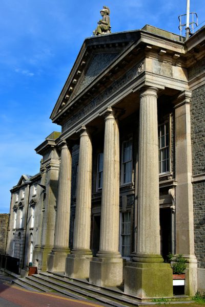
This neoclassical building was the Caernarvonshire Shire Hall when it was erected along Castle Ditch in 1863. Architect James Thomas specified the four fluted Doric columns holding the pediment accented with a dentil cornice. The statue of blindfolded Justice with a sword and wearing a galea, a Roman soldier’s helmet, was created by Robert Evans. After serving as the county hall, it became the chambers for the Crown and Magistrates Courts. As of this writing, it is unoccupied.
9-11 Castle Ditch Caernarfon LL55 2AU, UK Enlarge/Slideshow See On Map Directions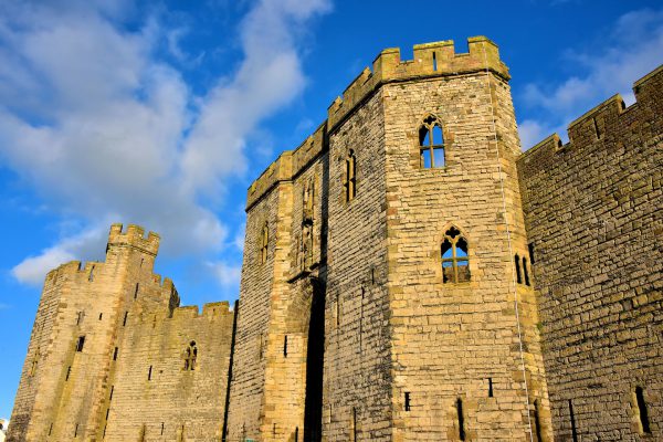
You are familiar with Charles, the current Prince of Wales. But how did the title become associated with the heir apparent to the English crown? It started and continues here. After the Welsh Prince Llywelyn ap Gruffydd was killed in 1281, King Edward I of England wanted to appease the rebellious people of Wales. So, when his son was born in Caernarfon Castle in 1284, he declared him to be the Prince of Wales. When his father died in 1307, Edward II became the King of England until he was imprisoned and suspiciously died twenty years later. Since 1911, the investiture ceremony to become the Prince of Wales has been held in this castle. The last time was 1969. Shown here are the Granary Tower (left) and the King’s Gate (center).
Caernarfon Castle Castle Ditch, Caernarfon LL55 2AY, UK Enlarge/Slideshow See On Map Directions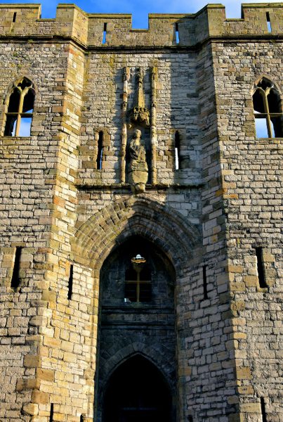
14th century intruders were greeted with murder holes when storming this King’s Gate. For invited guests, however, this was the grand entrance to Caernarfon Castle. So if you want a tour of this Middle Ages’ fortress, you are welcomed to enter here. You first pass under the worn carving of King Edward II which was added in 1321. The same admission price lets you visit the Museum of the Royal Welsh Fusiliers. This displays military artifacts of Wale’s oldest infantry regiment. If you need help or suggestions while visiting Caernarfon, there is an information office located across from this gate on Castle Ditch. Their staff is friendly and knowledgeable.
Caernarfon Castle Castle Ditch, Caernarfon LL55 2AY, UK Enlarge/Slideshow See On Map Directions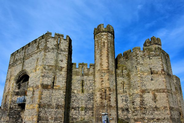
This is the eastern entrance to Caernarfon Castle facing Castle Square. The large archway is supported by two polygon-shaped towers. It was called the Banner Tower when it was used to receive cargo from the adjacent harbor. Now it is the Queen’s Gate. Queen Elizabeth visited here in 1955, in 1969 for the investiture of Charles as the Prince of wales, and again in 1975. In 2010, she and Prince Phillip were cheered as they waved from the glass balcony of Queen’s Gate.
Caernarfon Castle Castle Ditch, Caernarfon LL55 2AY, UK Enlarge/Slideshow See On Map Directions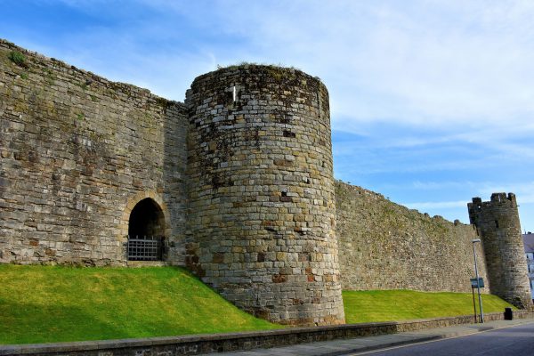
Construction of a town wall began around the time Caernarfon was deemed a borough in 1284 by Edward I of England. By the end of the 13th century, the medieval town was encircled by a 2,400 foot ribbon of stone. The citadel consisted of eight round towers like the two shown here on Greengate Street. They were declared a UNESCO World Heritage Site in 1986.
4 Castle Square, Caernarfon LL55 2NF, UK Enlarge/Slideshow See On Map Directions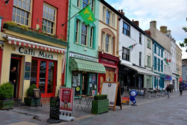
Caernarfon is not a shopping town. You won’t find big chains or luxury brands. Most visitors prefer it that way. They would rather explore small shops where the owner greets you with a smile. These charming stores inside of colorful Victorian and Gregorian buildings from the 19th century are located in Castle Square. The Welsh name is Y Mae. This square was extensively renovated in 2009.
6 Castle Square Caernarfon LL55 2NF, UK Enlarge/Slideshow See On Map Directions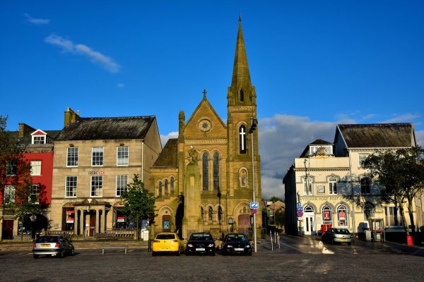
The prominent landmark defining the western edge of Castle Square is the castle. This photo shows the opposite or eastern side of the town plaza. In the center is Castle Square Presbyterian Church. When it opened in 1882, it served the Calvinistic Methodists. On the right is Caernarfon’s Post Office. Its Italianate design was finished in 1880. On the left is an HSBC branch. Originally, this 19th century building of Anglesey stone housed the North & South Wales Bank and then the Midland Bank.
Castle Square Caernarfon LL55, UK Enlarge/Slideshow See On Map Directions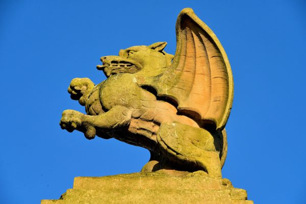
This sculpture of a rampart Welsh dragon has stood proudly on a stone column within Castle Square since 1922. It is a monument to soldiers who died during World War I and II. At the base of the cenotaph are two inscriptions in Welsh expressing Caernarfon’s love and admiration for their ultimate sacrifice.
Castle Square Caernarfon, UK Enlarge/Slideshow See On Map Directions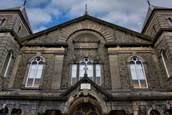
This Italianate-style, Salem Congregational Chapel was built on Pool Lane in 1862. It was commissioned by the Church of England and based on a design by Reverend Thomas. The flanking turrets were added in 1891 during an extension project managed by architect Owen Morris Roberts. This was about the same time a commemorative stone was laid honoring Dr. Herber Evan’s 25th anniversary of serving the church. During the late 19th century, Salem Chapel hosted the largest Sunday school program in Gwyneed.
13 Pool Hill Caernarfon LL55 2AL, UK Enlarge/Slideshow See On Map Directions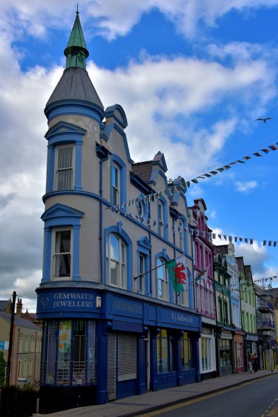
It was an unexpected delight to see this late 19th century, Victorian flatiron building on Bridge Street. Its light blue bay windows are the perfect accent to the conical roof topped with a green copper turret. On the ground floor is Gemwaith Jewellery. The top two stories of the triangular building are offices.
15 Bridge St, Caernarfon LL55 1AB, UK Enlarge/Slideshow See On Map Directions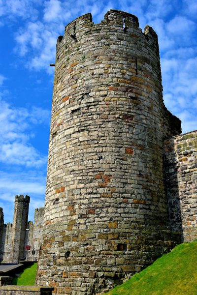
This tower along Greengate Street (and Hole in the Wall Street on the other side) is the southeast corner of the medieval wall. In the background is the Northeast Tower of Caernarfon Castle. It is appropriate to show them together because they were built simultaneously in 1285 based on the plans of architect James of St. George. Hundreds of English workers were employed to construct these massive defenses within a few years. They remain Wale’s finest historic strongholds.
4 Greengate St Caernarfon LL55 1AG, UK Enlarge/Slideshow See On Map Directions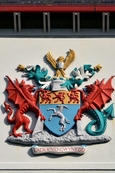
This was the coat of arms for the Gwyneed County Council from 1974 through 1996. On the left is The Red or Welsh Dragon. Y Ddraig Goch has been Wale’s symbol since 829 AD. On the right is the Sea Dragon. This represents the importance of the sea to the region. On top is the golden eagle from the arms of Hywel ab Owain Gwynedd, the Prince and King of Gwyneed during the 12th century. The bottom banner means, “The Strength of Gwyneed.” This heraldic design is located on the headquarters of the Gwyneed Council, the governing body for this region in northwest Wales.
Shirehall St Caernarfon LL55 1ZH, UK Enlarge/Slideshow See On Map Directions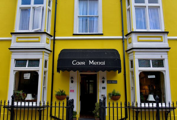
This Georgian/Victorian building along Church Street attracted my attention because of its bright yellow color. Then I read the plague erected by the Civic Society of Caernarfon. It explains this was the first country school when it was built in 1894. Their motto was to “Set standards of scholarship and culture.” It was transformed into a guest house in 1974. Now Caer Manai manages it as a B&B with seven guest rooms.
15 Church St Caernarfon LL55 1SW, UK Enlarge/Slideshow See On Map Directions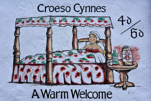
This mural on a 17th century building is entitled “A Warm Welcome.” It is a historical reference to when Northgate Street was Caernarfon’s red-light district. The 40/60 refers to the cost of a room, a bottle of gin and the company of a woman for the night. The painting also welcomes guests to the Black Boy Inn, a bed and breakfast that includes a pub and restaurant. Although its name may be controversial now, the moniker dates back to when it was established around 1522.
1 Stryd Pedwar a Chwech, Caernarfon LL55 1RW, UK Enlarge/Slideshow See On Map Directions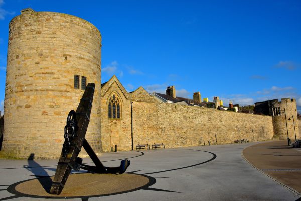
There is a lovely, seaside promenade stretching from the castle to Victoria Dock. It retraces the Slate Quay along the shore of Menai Strait. In the northwest corner there is a lot to admire. In the foreground is the five-ton anchor from the HMS Conway, an 1833 battle ship later used for naval training. Behind it is the Bell Tower, part of the 13th century town wall extending to the right. In 1307, this tower became part of the foundation for St Mary’s Church. The chapel was designed by Henry de Ellerton and built to serve the garrison who protected the city. The lancet window leads to the church’s vestry. On the far right is Bath Tower, so named when it was converted into part of a public bath in 1823. In between are benches. Sit here to watch glorious sunsets over the water.
19 Church St Caernarfon LL55 1SW, UK Enlarge/Slideshow See On Map Directions
Caernarfon’s western border is defined by the Menai Strait, a 16 mile channel separating the mainland from the Isle of Anglesey seen in the background. Anglesey is a 276 square mile island, the largest in Wales. It has a population of about 70,000 people. From the Holyhead port, ferries regularly travel 82 miles across the Irish Sea to reach Dublin, Ireland.
Bank Quay Caernarfon LL55 1SS, UK Enlarge/Slideshow See On Map Directions