Part 2 of the Virtual World Tour showcases another 50 international cities. Use the Locations list to find your favorite countries and cities. You will also enjoy exploring locations in all 50 states.
Part 2 of the Virtual World Tour showcases another 50 international cities. Use the Locations list to find your favorite countries and cities. You will also enjoy exploring locations in all 50 states.
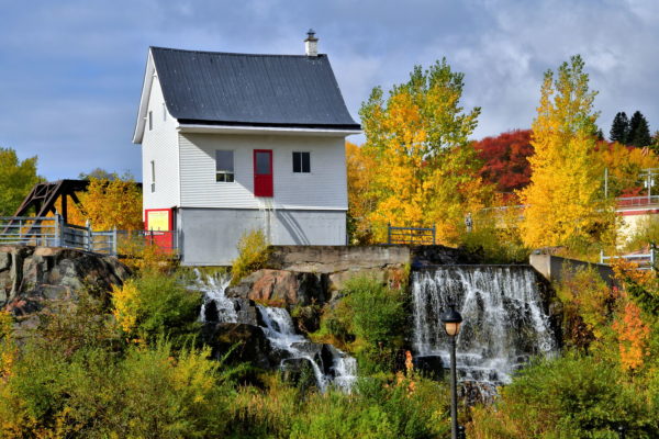
On July 19 and 20, 1996, a massive thunderstorm pounded Chicoutimi. The nearly ten inches of torrential rain triggered a catastrophic event know as The Saguenay Flood. Huge volumes of water overcame five dams and spillways before thundering into the Bassin District. The surge totally destroyed or severely damaged hundreds of houses. Only one remained standing: the former home of Elzéard Gagnon built in 1890. La Petite Maison Blanche (The Little White House) is now a museum about the flood. Notice the water pouring out of the red door. Surrounding the historic landmark is a municipal park where the neighboring residences were previously located.
251 Rue Bossé, Chicoutimi, QC G7J0K3, Canada Enlarge/Slideshow See On Map Directions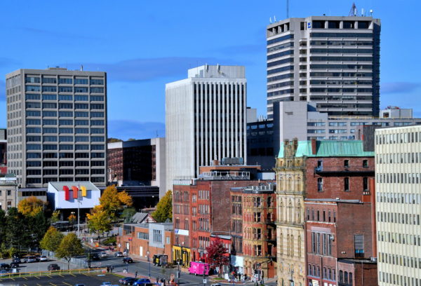
If you are one of the 175,000 annual cruise passengers visiting Saint John for the day, you will arrive at the Marco Polo Cruise Terminal. The facility is named after a three-masted wooden ship built at the port in 1851. Saint John has a population of about 70,000 … nearly twice more live in the metropolitan area. This qualifies as the second largest city in the province of New Brunswick. Saint John was founded by the French in 1604 and incorporated by the British in 1785. Now, it is your turn to explore the historic waterfront, the world’s most dramatic tide fluctuation plus the walkable Uptown (downtown) and neighborhoods. They are filled with predominately stone/brick storefronts and houses. Most were built during five years of the Victorian Era after a devasting fire in 1877.
111 Water St, Saint John, NB E2L 0B1, Canada Enlarge/Slideshow See On Map Directions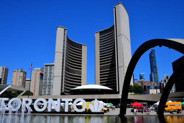
Superlatives fail to adequately describe Canada’s largest city and the capital of Ontario. The population of 5.5 million people enjoy an array of performing arts, professional sports, fascinating museums, historical landmarks, shopping alternatives, entertainment venues, diverse restaurants, heathy economy, a stunning skyline and a scenic waterfront. If you can’t find what you want in Toronto, then you really don’t need it. Your walking tour begins at Nathan Phillips Square. The highlights of this 12 acre plaza are a reflecting pool (becomes an ice rink in winter), the Freedom Arches and a Toronto sign with Canada’s maple leaf symbol. The Toronto City Hall is an impressive backdrop. The west tower (left) is 260 feet and the right one is 326 feet. The white saucer in the middle is the council chamber. Enjoy exploring Toronto!
100 Queen St W, Toronto, ON M5H 2N2, Canada Enlarge/Slideshow See On Map Directions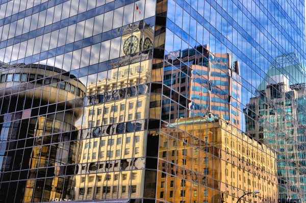
Downtown Vancouver, Canada is a sea of beautiful, modern and glass skyscrapers. In the Vancouver Block neighborhood is a 15 story building with white, terra cotta cladding. Atop this 1912 Edwardian landmark sits the Vancouver Clock Tower. This photo reflects the multi-generational architectural styles that grace the City of Vancouver in British Columbia.
Granville St & W Georgia St, Vancouver, BC, Canada Enlarge/Slideshow See On Map Directions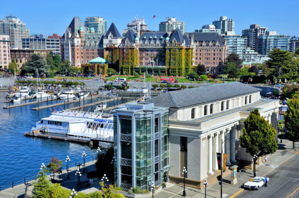
Center city Victoria is small (less than 90,000 people), safe, scenic and very easy to explore on foot. A great place to start is where Belleville Street (on the right) meets Government Street (in the background). This intersection is a showcase of major Victoria landmarks. Three were designed by prominent architect Francis Rattenbury. In the foreground is the Canadian Pacific Railway Steamship Terminal (1924). The vine-covered building is the famous Fairmont Empress Hotel (1908). And off camera on the right are the Parliament Buildings (1898). These are just an appetizer. From here, a waterfront promenade (Harbour Causeway) directs you along the Inner Harbour toward additional city highlights. This travel guide will point you along step by step.
470 Belleville St, Victoria, BC V8V 1W9, Canada Enlarge/Slideshow See On Map Directions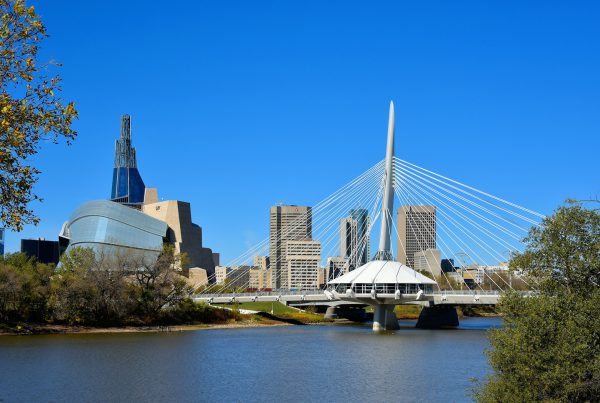
Welcome to Winnipeg, the capital of Manitoba, Canada. Come explore the history that dates back 6,000 years. The city has grown into the country’s seventh largest. You will find lush parks, converging rivers, professional sports, cultural venues, polar bears, stunning architecture, beautiful murals, a vibrant economy and 750,000 people who are proud of the “Gateway to the West.”
Avenue de la Cathedral & Tache Ave, Winnipeg, MB R2H 0H7, Canada Enlarge/Slideshow See On Map Directions
In 1866, a 34 year old Frenchman borrowed money to establish an engineering company. One of his first engineering assignments was to build an all metal, prefabricated building for a Chilean resort. But after the 1868 earthquake destroyed the First Church of Arica, the work of Gustav Eiffel became the Cathedral of San Marcos de Arica. Eiffel went on to become one of the most famous 19th century architects. His iconic work includes the Eiffel Tower and the Statue of Liberty.
Bolognesi 199 Arica, Región de Arica y Parinacota, Chile Enlarge/Slideshow See On Map Directions
Icebergs floating along the southern Pacific coast of Chile often appear blue. This is an optical illusion caused by the ice crystals scattering the sunlight. When a chunk breaks off the nine-mile San Rafael Glacier, it sounds like dynamite followed by an enormous wave. Then, the 300,000 year-old sculptures travel gracefully until melted by the sea. Unfortunately, the two million acre ice field called Campo De Hielo Norte is retreating by over 600 feet a year.
Laguna San Rafael National Park, Aysén Region, Chile Enlarge/Slideshow See On Map Directions
The sunsets over the Pacific Ocean on the southern Chilean coast are unusually spectacular with intense reds and oranges that dance off ribbons of swirling clouds. It makes dusk a beautiful and magical time of the day.
[-43.106616, -74.595965] Enlarge/Slideshow See On Map Directions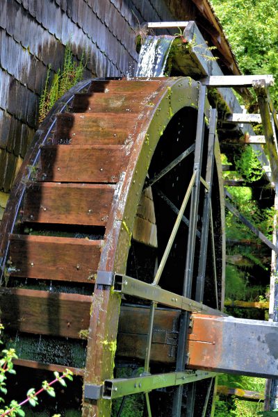
The turning wooden blades on this waterwheel once powered a grinding stone for milling flour and processing other crops grown by German immigrants. The El Molino (millhouse) is part of Museo Colonial Alemán, an outdoor museum established in 1984 by Universidad Austral and the Municipality of Frutillar. You can also tour the barn where the grain was stored and see the equipment used in the late 1800s for farming.
V-155 410, Frutillar, X Región, Chile Enlarge/Slideshow See On Map Directions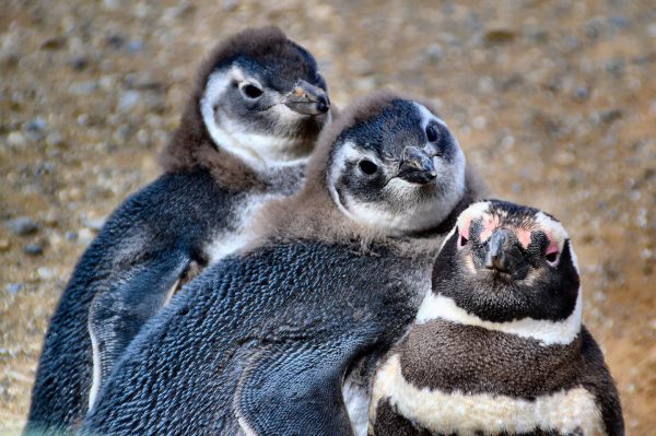
If you like penguins, you will love seeing over 63,000 breeding pairs on Magdalena Island in southern Chile. In this family portrait, the two birds with grey-blue coloring are chicks. An average of 1.4 chicks per nest survives each year. The adults can live up to 20-25 years and mate for life.
Magdalena Island, Magallanes y la Antártica, Chilena Region, Chile Enlarge/Slideshow See On Map Directions
Since the Spanish conquistadors introduced wine to Chileans in the mid-16th century, vineyards have boomed along an 800 mile stretch. Collectively they grow 25 varieties of grapes. The most productive area is the Central Valley Region and especially the Maipo Valley just south of Santiago. The climate and soil are perfect for cabernet sauvignons.
Av. Concha Y Toro 2055, Pirque, Región Metropolitana, Chile Enlarge/Slideshow See On Map Directions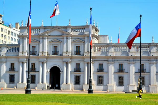
This was Chile’s national royal mint when it opened in 1805. La Moneda means “the coin.” Forty years later, the building was converted into the president’s residence. Today, it serves as the offices for the president and several cabinet ministries. The grassy area is called Plaza de la Constitucíon. The commons was added during the 1930s. The Neoclassical style of Palacio de La Moneda was designed by Joaquín Toesca. He was a prolific architect who served the Spaniards in Santiago during the second half of the 18th century.
Moneda S/N, Santiago, Región Metropolitana, Chile Enlarge/Slideshow See On Map Directions
A must-do experience while vacationing in Valparaíso is riding a funicular. One of the best is Ascensor Artillería. Built next to an earlier elevator in 1908, the lift’s 574 foot assent takes only 80 seconds to reach this station at the top of Artillería Hill. The ride is fun, the views of the city and harbor from Paseo 21 de Mayo terrace are terrific and the Playa Ancha neighborhood is interesting to explore, especially the nearby National Maritime Museum.
Paseo 21 De Mayo Valpo Paseo Veintiuno de Mayo 108, Valparaíso, Región de Valparaíso, Chile Enlarge/Slideshow See On Map Directions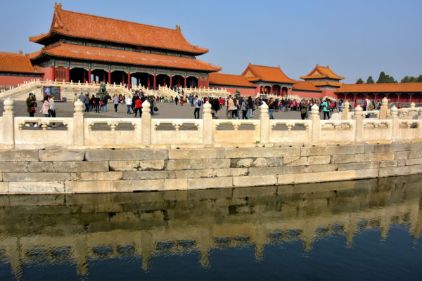
Forbidden City is the must see attraction in Beijing. Constructed in the early 15th century, this former home to 24 emperors showcases almost 1,000 exquisite examples of Chinese palatial architecture. From 1420 until 1912, you could not enter the property without permission from the emperor. But after the end of the Qing dynasty, the 180 acre complex opened in 1925 as the Palace Museum. Now this UNESCO World Heritage Site welcomes about 16 million visitors a year, making it the world’s number one tourist attraction. One beautiful example of why Forbidden City is so popular is this view of the Gate of Supreme Harmony with marble balustrades reflecting on Inner Golden Water River. On the right are the Gate of Manifest Virtue (Zhaode men) and the Lofty Pavilion (Chong lou).
Meridian Gate, Dongcheng Qu, Donghuamen Rd, Beijing Shi, China, 100006 Enlarge/Slideshow See On Map Directions
Chongqing, which means “Celebrate Again,” is in southwest China along the 4,000 mile Yangtze River. The municipality’s 29 million people are equivalent to the top 15 U.S. cities combined. A haven from this crowd is Eling Park which was created in 1909. Also called Goose Neck Park, it provides spectacular views from atop Eling Mountain. Enjoy a quiet stroll through the beautiful Qing Dynasty’s gardens, which include lotus ponds, bamboo groves, a zoo and arc bridges.
181 Eling Main St, Yuzhong Qu, Chongqing Shi, China, 400014 Enlarge/Slideshow See On Map Directions
Octopus, meat, lamb, chicken, seafood, insects and just about anything edible are frequently skewered at street markets in China and deep fried into a Chinese kebab called Chuanr. When selected by a customer, the vendor covers the food in oil, seasons it with salt and pepper and then roasts it over a charcoal grill. The aromas of this Asian fast food can be wonderful. Or the customer can prepare these delicacies at home.
Enlarge/Slideshow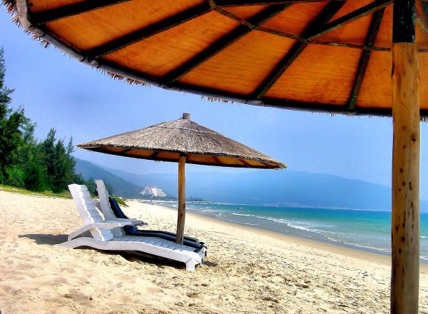
Hainan is an island in the South China Sea whose capital is Sanya. Until recently, it was unspoiled. Away from the few cities, you will see tropical forests and farmers in conical straw hats guiding oxen through rice paddies. The coastline offers pristine beaches and bays like Haitang where thatched umbrellas and loungers welcome you to a perfect afternoon. Fortunately or unfortunately, Sanya has been discovered by major hotel chains.
Ye Zhou Lu Haitang Qu, Sanya Shi, Hainan Sheng, China Enlarge/Slideshow See On Map Directions
The Oriental Pearl Tower is a stunning landmark in the Pudong district of Shanghai, China, the world’s largest city with nearly 18 million people. It was built in 1994 for radio and TV transmissions but is also home to restaurants, a mall, a hotel and an observation deck at over 1,100 feet. The design has 11 spheres, but the two large pink ones are the most prominent.
Enlarge/Slideshow
In China street markets, chicken are sold plucked and hanging in a window or alive so customers can judge their health. At this “wet” market in Wanxian, China, a customer selected the rooster with its head up. The shopkeeper’s right hand grabbed it by the neck immediately after this photo was taken. Footnote: Two-thirds of Wanxian, a city that dated back to the Ming dynasty starting in the late 14th century, was flooded by the Three Gorges Dam reservoir in 2008. In preparation, approximately 80,000 people were displaced and 900 factories were moved. The area is now called Wanzhou District and is considered part of the Chongqing municipality.
Enlarge/Slideshow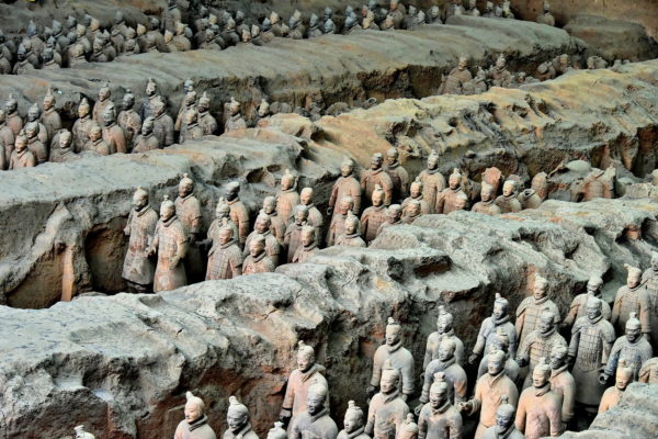
Construction of the final resting place for Zheng began in 246 BC shortly after he became the King of Qin at the age of 13. In 221 BC, he defeated the last of China’s Warring States and was renamed Qin Shi Huang. During his eleven-year reign as the First Emperor of Qin (and China), approximately 700,000 men labored over his mausoleum. The project was finished in 208 BC, two years after the emperor’s death. The measurements are staggering. At the center is an unexcavated mound shaped like a 250 foot tall subterranean pyramid. Encircling the emperor’s tomb underground are a 1.5 mile inner city and a 3.9 mile outer city. Their design resembles Xianyang, the capital of the Qin dynasty. Archeologists estimate there are 600 burial sites within the surrounding 35 square miles. They contain the bodies of the royal family, government officials, high-ranking army members, concubines and mausoleum laborers. The impressive Terracotta Army seen in Pit Number One are only a fraction of this enormous complex. Simultaneous to the construction of the mausoleum, Qin Shi Huang ordered a massive extension of a defense along China’s northern border. The 10,000-li Great Wall stretched for over 3,100 miles.
Qin Shi Huang Mausoleum, Lintong District, Xi’an, Shanxi, China 710612 Enlarge/Slideshow See On Map Directions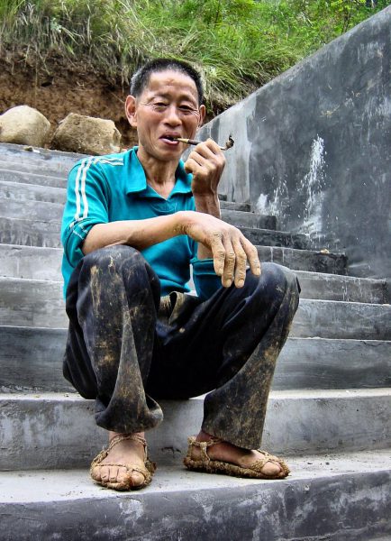
The Yangtze River flows through China for nearly 4,000 miles. Before the Shennong Stream empties into the Yangtze near the Wu Gorge, it zigzags from atop the Shennong Jia peak through narrow passages, lush vegetation, spectacular canyons, waterfalls and rocky shores. The peasants that navigate these treacherous waters are called Tujia. They expertly steer their sampans (called peapod boats) using primitive, long paddles or, when stuck in the shallows, they drag the boat by rope. This Tujia man was taking a break for a smoke on his opium pipe.
Enlarge/Slideshow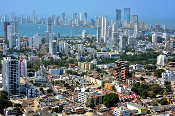
This panoramic view of Cartagena from Convent de la Popa shows its very modern cityscape. There are about 150 high-rises and skyscrapers. The majority have been built since 2003, especially in the Bocagrande neighborhood in the background. Most of them are condominiums to house the population of about 900,000 people. Several are luxury hotels with lots more planned. The towers in the middle stand on Manga Island. Some real estate experts have compared Cartagena’s construction boom to Panama City and Miami.
Convent of Santa Cruz de la Popa Cl. 37, Cartagena, Bolívar, Colombia Enlarge/Slideshow See On Map Directions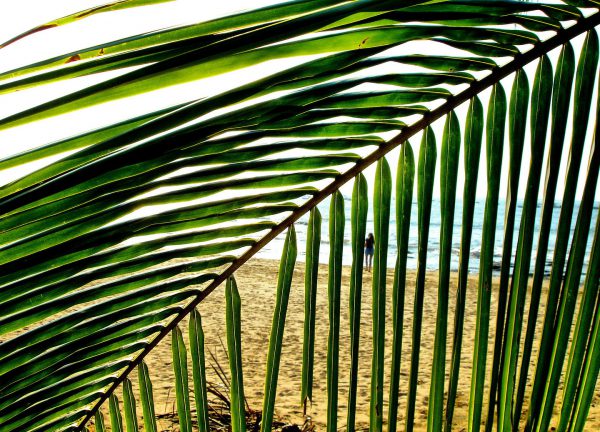
Tamarindo, Costa Rica, is perfect for suffers: small and laidback with white, pristine beaches and perfect waves. It was made famous in the 1994 surfer movie “Endless Summer II” yet remains unspoiled. For example, you are likely to see cows rooming the one dusty street in this town of 500. So, if you’re looking for isolation and warmth, then go to Playa Tamarindo, side step the Leatherback Turtles and put your toes into the Pacific Ocean like this woman seen through the palm leaves.
Calle Cruz, Provincia de Guanacaste, Tamarindo, Costa Rica Enlarge/Slideshow See On Map Directions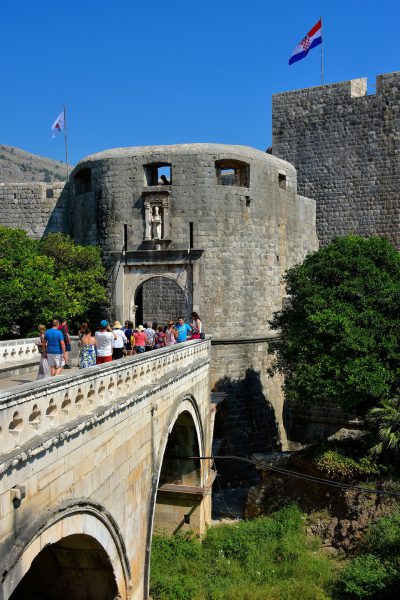
The main entrance to Stari grad Dubrovnik or Dubrovnik’s Old Town is through the Pile Gate. Look up before walking through this early 16th century Outer City gate. Above the arch is a statue of a bearded man wearing a robe and a mitre or bishop’s hat. He is holding a staff and a model of the city. This is Saint Blaise who is Dubrovnik’s patron saint. You’ll see his image repeatedly inside one of the world’s best walled-in cities. Now proceed through the Vrata od Pilla to discover why this entire town is a UNESCO World Heritage Site.
Ul. Vrata od Pila, 20000, Dubrovnik, Croatia Enlarge/Slideshow See On Map Directions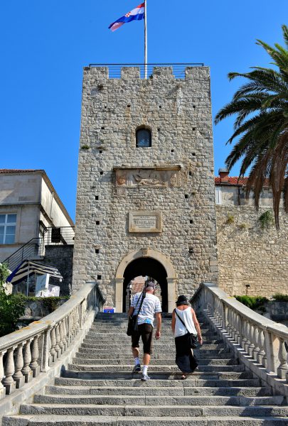
Since the 13th century, the Revelin Tower has been the major entry to Old Town from the south. It is also called the Dry Land Gate because it is the only one not facing the water. In 1863, this grand staircase replaced an earlier one. Above the arched portal is a plaque commemorating the millennium crowing of Tomislav. He became the first king of the Croatian Kingdom in 925 AD.
Ul. Korčulanskog statuta 1214, 20260, Korčula, Croatia Enlarge/Slideshow See On Map Directions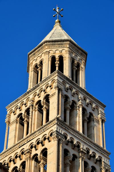
The bell tower of Split deserves close inspection. Construction of this Romanesque masterpiece began during the 13th century and required 300 years of dedicated craftsmanship to complete. Although it was largely rebuilt from 1890 through 1906, it retains much of its original elegance. Notice and appreciate the blend of classic architectural elements including Corinthian columns and a scallop motif below the delicately carved cornice. Exquisite!
Peristil ul. 2, 21000, Split, Croatia Enlarge/Slideshow See On Map Directions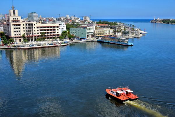
In 1515, the Spanish established Villa de San Cristóbel de la Habana as their first town in Cuba because of the large, natural bay. Five years later, they created the Port of Havana to harbor their Fleet of the Indies during their trade routes between Spain and the New World. It was not long before ships laden with treasures attracted the attention of pirates. To defend against the attacks, the Spaniards built four fortresses from 1590 through 1774. In the background is one of them: Castle of the Morro. As navigational trade flourished, so did the city. The port was extensively expanded between 1790 and 1850. In 1898, the battleship USS Maine exploded and sunk in the harbor. This aggression sparked the Spanish-American War leading to the end of Spanish control. The American’s invested in the port’s infrastructure for a few years until 1902 when the Republic of Cuba was formed. Further enhancements during the 20th century have been limited.
Canal de Entrada, Havana, Cuba Enlarge/Slideshow See On Map Directions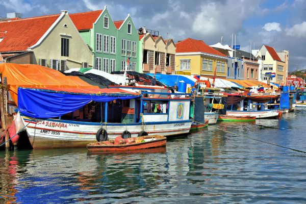
This view of the Floating Market from the Queen Wilhelmina bridge makes it seem the market is conducted from the tethered boats along the Waaigat waterfront. However, behind those tarps are produce stalls brimming with fresh fruits, vegetables and fish. They are built along the colorful buildings of Shailio Caprileskade. Many Venezuelan merchants live in those small wooden boats. They also use them to transport their fresh product from their homeland 40 miles away across the Caribbean.
Kon. Wilhelminabrug Willemstad, Curaçao Enlarge/Slideshow See On Map Directions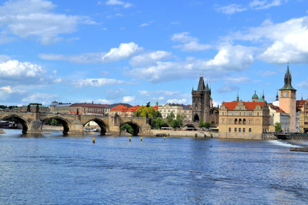
This iconic view of Prague shows the Charles Bridge spanning the Vltava river as it connects with Old Town. Staré Město became a walled-in settlement after it was founded in the 9th century. Holy Roman Emperor Charles IV commissioned this namesake bridge after its predecessor, the 12th century Judith Bridge, was crippled by floodwaters in 1342. The designer was Petr Parléř, the same architect who created its eastern gate, the Old Town Bridge Tower in the center of the photo. Construction of the 16-arch bridge was finished in 1402. After an extensive restoration ending in 1978, Karlův most has been restricted to pedestrians. This very popular landmark is typically packed with camera-ready tourists taking photos of the 30 sculptures lining its 1,692 foot length.
Karlův most, 110 00 Praha 1, Czechia Enlarge/Slideshow See On Map Directions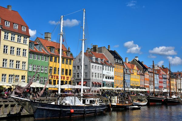
These ships are moored at the quay on Nyhaven. The docked vessels continue a tradition dating back to 1673 when this inner harbor was dug out by prisoners at the command of King Christian V. For the next 400 years, it grew into a major shipping port but then tapered off in the late 1940s. Today, traffic consists of some working vessels, restored wooden sailing ships plus sightseeing boats.
Nyhavn 2, 1051 København, Denmark Enlarge/Slideshow See On Map Directions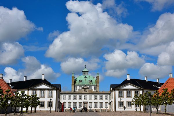
When the initial pleasure palace for King Frederick IV was finished in 1726, it was a modest building of one-and-a-half stories. His successor, King Christian VI, initiated a significant expansion in 1741 that would stretch through the reigns of two more Danish kings. By 1770, it had evolved into an elaborate, octagonal-shaped complex complete with riding stables and a huge garden. It became a favorite venue for monarchs to spend their holidays plus their spring and summer months.
Slottet 1B, 3480 Fredensborg, Denmark Enlarge/Slideshow See On Map Directions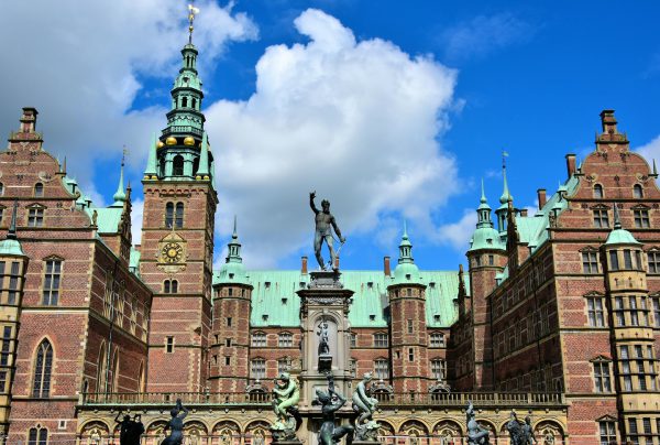
It is a delightful challenge for your eyes to drink in all of the magnificent details of the Frederiksborg Castle. The slot’s red brick façade is adorned with a clock tower, copper-crowned spires plus mythological and Renaissance sculptures. In the foreground is a reproduction of the Neptune Fountain. The original was installed in 1620 but then seized by Swedish soldiers in 1659 during the Second Northern War. Jacob Christian Jacobsen, the founder of Carlsberg brewery, paid for the fountain to be recreated in 1888.
Frederiksborg Slot 10, 3400 Hillerød, Denmark Enlarge/Slideshow See On Map Directions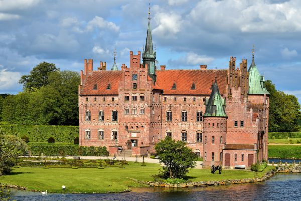
During the mid-16th century, Denmark was plagued by civil wars plus political and religious upheaval. Therefore, it was common for Dutch noblemen like Frands Brockenhuus to build a fortress to defend their estate and family from attacks. The design of the Egeskov Slot included a wide moat, three foot walls, battlements, arrow slits plus machicolations for dropping stones or scalding oil from the towers onto attackers below.
Gade 18, 5772 Kværndrup, Denmark Enlarge/Slideshow See On Map Directions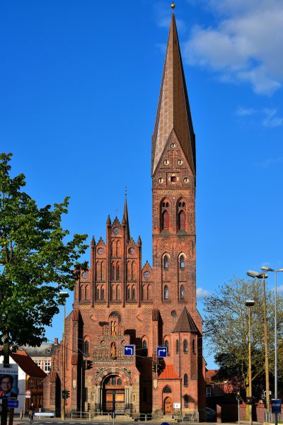
This photo was taken along a long boulevard called Sankt Knuds Plads. It shows the spectacular spire of St. Alban’s Church which soars 177 feet in the center of Odense, Denmark. It is sometimes confused with the St. Alban’s Church were Canute IV of Denmark was killed in 1086. That historic site was near here but no longer exists. This St. Alban’s Church was built in a neo-gothic style in 1908.
Adelgade 1, 5000 Odense C, Denmark Enlarge/Slideshow See On Map Directions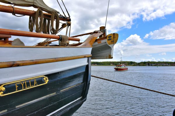
Svendborg was founded during the first half of the 12th century. The early settlers were attracted to the natural harbor of the Svendborg Sound, leading to an early growth from shipping. This trend flourished in the early 20th century when a shipyard became a major employer until it closed in 2001. In the foreground is Fylla, a three-mast schooner. It was named Funen when it was built in 1922. It is now a charter ship.
Havnepladsen 3 A, 5700 Svendborg, Denmark Enlarge/Slideshow See On Map Directions
From 1958 until 1983, Charles Bluhdorn was the founder and president of Gulf & Western, a Fortune 500 conglomerate. One of his passions was the Dominican Republic. In 1967, he purchased a local sugarcane company and began building Casa de Campo, his dream mega-resort. Among his inspirations was recreating a 16th century Mediterranean village on the property. He chose Roberto Copa to be the co-architect. Copa was a senior set designer for Paramount Studios, one of Bluhdorn’s subsidiaries. When Altos de Chavón opened in 1982, the results were magical. Flanking the cobblestone streets are restaurants, shops and galleries. They are tucked inside 16th century architecture reproductions crafted from coral blocks. In the center is St. Stanislaus Church. Its namesake is the 11th century bishop of Kraków and the patron saint of Poland. Iglesia San Estanislao de Cracovia is not a prop. The church was consecrated by Pope John II in 1979 and conducts masses on the weekends.
Casa de Campo, Carr La Romana - Higüey, La Romana 22000, Dominican Republic Enlarge/Slideshow See On Map Directions
The public beach at Cabeza de Toro is delightful if you want to experience an undeveloped coastline epitomizing the Caribbean. The turquoise water is shallow, warm and calm … perfect for swimming and snorkeling. The sand is not groomed but a brilliant white and wide. The rows of palm trees are not cluttered with rows of beach chairs and loungers. And you will enjoy wildlife instead of a wild social life. Cabeza de Toro is the essence of peaceful tranquility.
Playa Cabeza de Toro, Punta Cana 23000, Dominican Republic Enlarge/Slideshow See On Map Directions
These pastel buildings near the Bay of Samaná along the Avenida la Marina look like a painter’s pallet. The colonial row houses have a quaint village appearance. Inside they are designed to attract tourists’ wallets. On the right is the Samaná Casino. It is small with about 50 slots and a couple card tables. The rest are part of Plaza Pueblo Principe, a center containing shops, restaurants and nightlife. This property is owned by Gran Bahia Principe Cayacoa, a resort located a short distance away.
Plaza Pueblo Principe, Avenida La Marina, Samaná 32000, Dominican Republic Enlarge/Slideshow See On Map Directions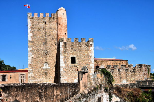
Fray Nicolás de Ovando had valid reasons to believe Santo Domingo was vulnerable to attack when he became governor in 1502. The riches from the gold rush of 1500 to 1508 had attracted the attention of potential French and British conquerors plus pirates. The enslaved Indigenous Taíno people were increasingly combative as their population shrank from disease and abuse while working the mines. So he ordered the construction of Ozama Fortress. The initial citadel was finished in 1508. The 59 foot Tower of Homage was added in 1509. Torre del Homenaje became the temporary residence of Diego Columbus (eldest son of Christopher) when he was appointed Governor of the Indies in the same year. Throughout most of the ensuing 500 years, Ozama Fortress was a prison. Many political adversaries were incarcerated and executed here until the 1960s.
Calle Las Damas 1, Santo Domingo 10210, Dominican Republic Enlarge/Slideshow See On Map Directions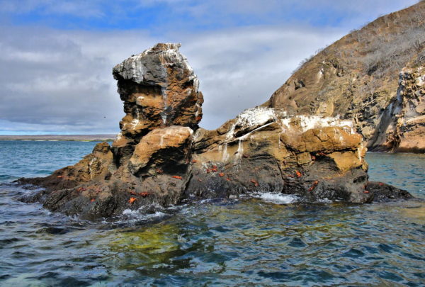
Eden Island is a sliver of volcanic rock located along the northwest shore of the large Santa Cruz Island. Isla El Edén measures less than 2,000 square feet in diameter. Despite its small size of .01 square miles, it exhibits three distinct landscapes. One is flat, arid and barren (seen on the left). In the middle is a 233 foot cliff. Later in this guide you will visually tour its lush, tranquil yet rugged coast. Sally Lightfoot crabs appear to love riding this horse-shaped sea stack. The huge colony of crabs includes all sizes, from small black hatchlings to bright red and orange adults measuring three to five inches.
Isla El Edén, Ecuador Enlarge/Slideshow See On Map Directions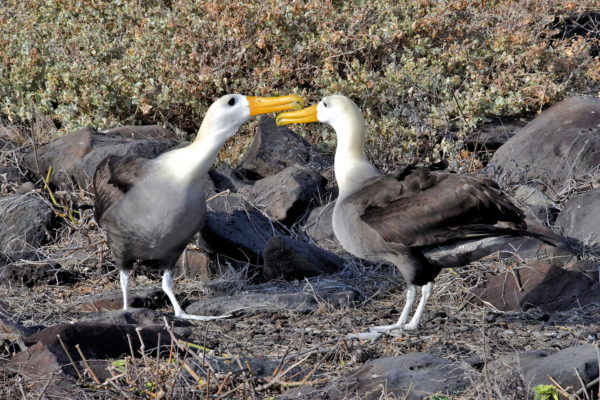
Waved albatross are monogamous. Finding the perfect mate involves an elaborate courtship. These two were actively flirting with hopes of finding true love. The ritual is fascinating to watch. The birds parade around each other. They fence with their long orange beaks, snapping them open and closed amongst loud chattering. Their heads bob in unison and their wings flap with excitement as the dance continues. This couple ended by intertwining their long white necks. Clearly, it was time to purchase an engagement ring.
Punta Suárez, Española Island, Ecuador Enlarge/Slideshow See On Map Directions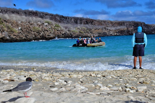
While cruising around the Galápagos Islands, you itinerary typically includes two excursions a day. After your ship anchors in open water, you will board an inflatable raft for a short journey to the next destination. There are two types of landings: wet and dry. The former means you will step into shallow water along the shore. Good water shoes are a must. There to help you disembark are members of the crew and the occasional swallow-tailed gull. Welcome to Darwin Bay Beach on Genovesa Island.
Great Darwin Bay, Genovesa Island, Galápagos, Ecuador Enlarge/Slideshow See On Map Directions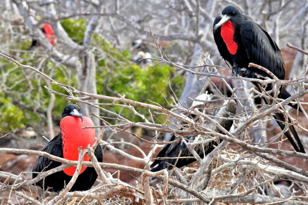
You will never forget seeing a male magnificent frigatebird with an enormous red balloon below the neck. The color is intensified by their black feathers and the surrounding white brush where they perch. This scarlet throat pouch is inflated during mating season to attract females. Notice the deflated sac of the bird on the right. Most pelecaniformes – such as pelicans and related marine birds – have a similar gular pouch. It is designed to scoop up fish and then drain water before eating. But the frigatebird has elevated this feature to a dramatic flamboyance.
North Seymour Island, Ecuador Enlarge/Slideshow See On Map Directions
As you arrive for a dry landing at Plaza Sur, there will be sea lions of all ages playing in the water, following your inflatable raft and hauling out on a small concrete pier and the shoreline. The pups are inquisitive and adorable. A watchful dominate bull can weigh up to 550 pounds. The colony consists of about 1,000 Galápagos sea lions. This is remarkable given the tiny size of the island. Plaza Sur measures only 32 acres or .05 square miles. Alternative names are South Plaza Island and Isla Plaza Sur.
Isla Plaza Sur, Ecuador Enlarge/Slideshow See On Map Directions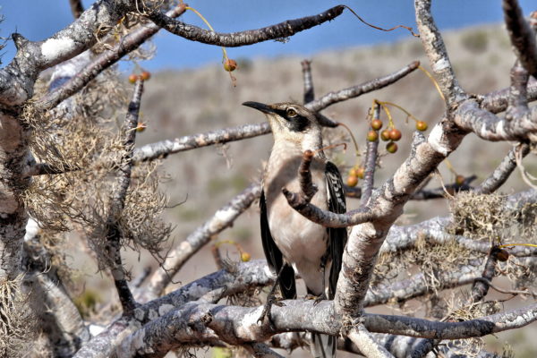
Finches are often believed to be the inspiration for Charles Darwin’s theory of evolution. Although they contributed to his breakthrough discovery, the various finch species were not identified until two years after his Galápagos visit. Yet Darwin did observe uniqueness among mockingbirds. He called them mocking-thrushes. An entry in his extensive journal aboard HMS Beagle exclaimed he was astonished to see different species even from neighboring islands. There are four species of mockingbirds endemic to the Galápagos and six subspecies. The type living on Isla Rábida and three other islands is Mimus parvulus personatus. Part of the bird’s diet is eating fruit. The seeds pass through the feces and germinate elsewhere.
Rábida Island, Ecuador Enlarge/Slideshow See On Map Directions
As you approach Punta Pitt, you will notice something unusual about the 295 foot beach. The sand has a green hue. This color stems from translucent olivine crystals reflecting in the light. Although this mineral is very common inside of the earth, it tends to weather quickly when exposed to air, wind and waves so rarely retains its olive coloring. They occurred at Punta Pitt because the mineral content of the volcanic ash was high in magnesium and low in silica.
Punta Pitt, San Cristóbal Island, Ecuador Enlarge/Slideshow See On Map Directions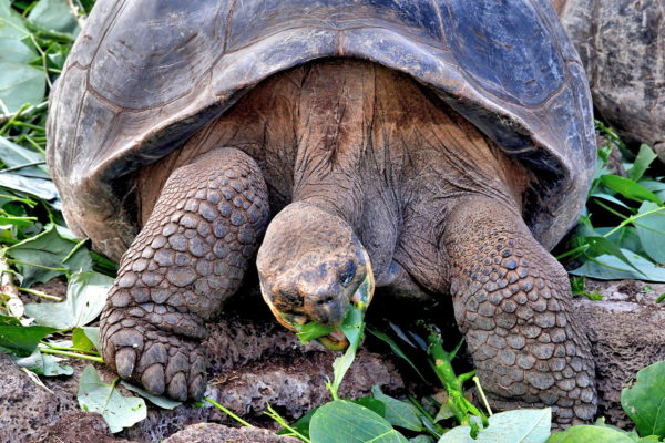
The Galápagos tortoise richly deserves the common adjective of “giant.” An average adult of this endemic species – the largest in the world – weighs 400 pounds. Yet size varies by island. The biggest are native to Santa Cruz Island. Males here can measure up to five feet and be nearly 500 pounds. The largest was 6.1 feet and 880 pounds. Their scale-covered legs have to be enormous to carry that much weight. There are five claws on the front legs and four on the back pair. Their carapace (shell) is either saddleback, domed or a variation of the two. Most impressive is their life expectancy. In the wild, they typically live over 100 years. Harriet was the oldest in captivity when she died at 170 years old in Australia Zoo. With that much time, who needs to hurry?
Charles Darwin Research Station, Ave Charles Darwin, Puerto Ayora, Ecuador Enlarge/Slideshow See On Map Directions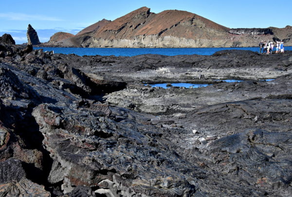
Your tour of the volcanic formations at Santiago Island will last about 90 minutes. The difficultly of this excursion is rated as intermediate. The tricky part is watching where you step. Although this fascinating landscape is relatively flat, it is filled with uneven surfaces, crevices and the occasional crevasse. Your small group will be led by a certified guide. He or she will passionately explain every nuance of volcanoes and the geological idiosyncrasies of what you are admiring. By the end of the one mile circular hike, you might feel like a trained volcanologist.
Sullivan Bay, Santiago Island, Ecuador Enlarge/Slideshow See On Map Directions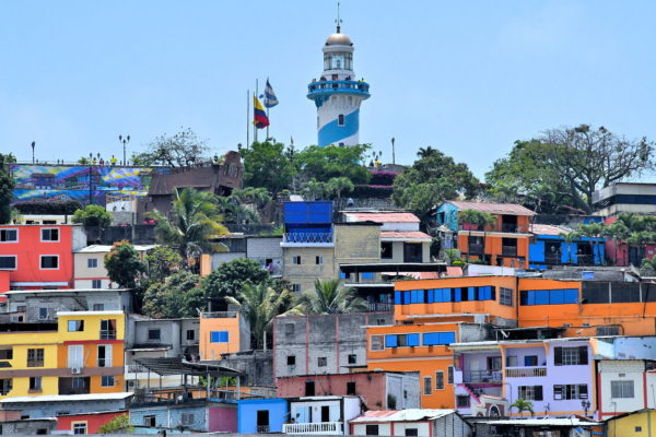
This 61.5 foot lighthouse with the blue and white stripes at the 197 foot summit of Santa Ana Hill is the symbol of Guayaquil. The initial Spanish settlement was founded in the 1530s. After being destroyed twice by indigenous people, it relocated here at the base of Little Green Hill in 1547. Since then, Guayaquil has become Ecuador’s largest city with over two million residents. From the light’s observation deck, you can enjoy a panoramic view of many of the landmarks in the Old and New Towns plus the Guayas River.
Diego Noboa y Arteta, Escalon 444 Cerro Santa Ana, Guayaquil 090313, Ecuador Enlarge/Slideshow See On Map Directions
Eloy Alfaro was president of Ecuador at the turn of the 20th century. He is credited with building the country’s unity, education, railroad and infrastructure but he also suppressed the Catholic Church. In 1911, he was deposed. A year later, he was murdered by a mob. This monument to Eloy Alfaro is at the Alfaro City Civic Center Square on a hill known as El Centinela. The tribute overlooks Montecristi, the town best known for originating the Panama hat.
Civic Center, Ciudad Alfaro, Montecristi, Ecuador Enlarge/Slideshow See On Map DirectionsThe Historic Centre of Quito is an 800 acre time capsule of Spanish architecture blended with European and Ecuadorian indigenous designs. Flanking the cobblestone streets are marvelous churches and monasteries, former opulent palaces, two-story houses with balconies and red-tile roofs, fascinating museums and quaint squares. The iconic landmarks range from the mid-16th century like the Cathedral of Quito to the Virgin of Quito statue erected in 1976. In 1978, Centro Histórico was the first to be named by UNESCO as a World Heritage Site in its entirety. El Centro is also so charming it earned the nickname “Florence of America.”
Chile & Venezuela Streets, Quito 170401, Ecuador Enlarge/Slideshow See On Map Directions