I typically seek out lighthouses when visiting a coastal city. Sure I admire their structures and enjoy photographing them. A huge side benefit is they often face stunning seascapes.
I typically seek out lighthouses when visiting a coastal city. Sure I admire their structures and enjoy photographing them. A huge side benefit is they often face stunning seascapes.
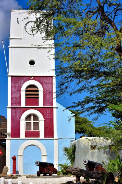
Oranjestad’s oldest building was constructed in 1798 as a Dutch fortress. At its base are two of the original canons. The Willem III Tower, named after the King of the Netherlands (1849-1890), was added to Fort Zoutman in 1868. It functioned as a lighthouse for almost 100 years. After an extensive renovation, the old citadel became the Historical Museum of Aruba in 1984.
Fort Zoutman, Zoutmanstraat 6, Oranjestad, Aruba Enlarge/Slideshow See On Map Directions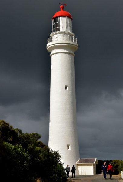
A visual highlight of Aireys Inlet – a seaside hamlet of 800 people along the Great Ocean Road – is Split Point Lighthouse. The 217 foot, cylindrical tower was built on a 230 foot cliff near Eagle Rock Lookout in 1891 and automated in 1919. Affectionately known by locals as White Queen or White Lady, her red beacon is visible 18 miles into Bass Strait. Despite the loaming thunderstorm, these people were excited to take a tour, including climbing the 132 stairs to the light’s observation deck.
24 Federal St, Aireys Inlet VIC 3231, Australia Enlarge/Slideshow See On Map Directions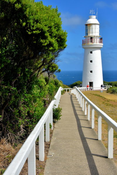
The main attraction on Cape Otway is this lighthouse, the oldest in mainland Australia. It was placed on top of an isolate, 295 foot coastal cliff in 1848. Its mission was to reduce the number of ships that sunk while threading “The Eye of the Needle.” Despite the Beacon of Hope’s powerful Fresnel lens, there were six more shipwrecks by the end of the 19th century. You can also visit the Head Lightkeeper’s Cottage and then have a snack of scones with coffee or tea at the former Assistant Keepers Quarters built in 1858.
Cape Otway Lighthouse, Otway Lighthouse Rd, Cape Otway VIC 3233, Australia Enlarge/Slideshow See On Map Directions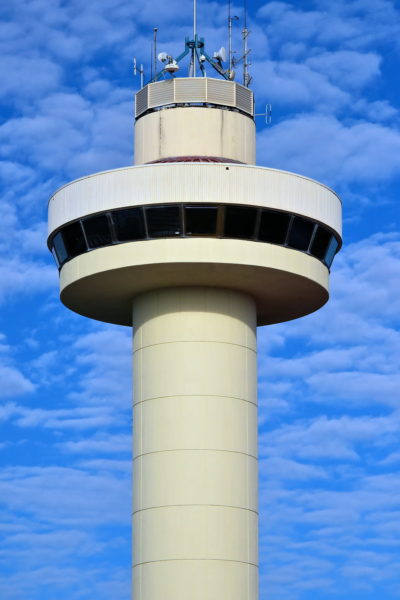
Hobart’s main port for commercial, Navy and passenger vessels consists of six terminals called Macquarie Wharf. Controllers manage the maritime traffic guided by pilot boats from atop Hobart Port Tower. Its elevation of 135 feet provides a commanding view of Sullivans Cove and the Derwent River.
Hobart Port Tower, Hunter St, Hobart TAS 7000, Australia Enlarge/Slideshow See On Map Directions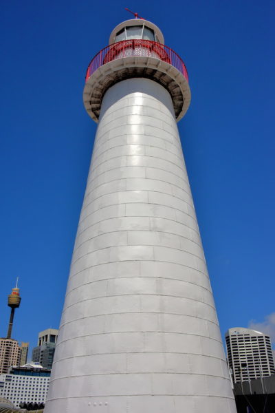
In 1874, the Cape Bowling Green Lighthouse – after being prefabricated in Brisbane – became operational on a headland about 44 miles south of Townsville. It was one of 22 lights protecting the coastline of Queensland in the late 19th century. In 1987, the 82 foot conical tower was relocated adjacent to the Australian National Maritime Museum at Darling Harbour in Sydney.
2 Murray St, Sydney NSW 2000, Australia Enlarge/Slideshow See On Map Directions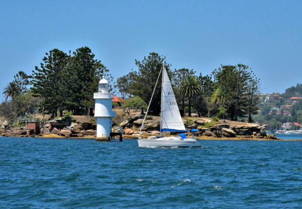
Shark Island is a tiny, 3.7 acre rocky islet near Rose Bay in Sydney Harbour. It is only accessible by water like this passing sailboat or by ferry. Protecting the shoreline is a pile light. This 39 foot tall, cylindrical tower was built in 1913 and remains operational.
Shark Island, Sydney NSW Australia Enlarge/Slideshow See On Map Directions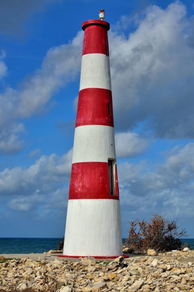
Pinder’s Point was built in the 1960s shortly after a creek was dredged to create the Freeport Harbour (now called the Lucayan Harbour). The 40 foot, cinder-block lighthouse has three red and three white, horizontal stripes. This Grand Bahama Heritage Site is currently inactive. It replaced an early 19th century lighthouse named Eight Mile Rock Lite.
Pinder’s Point Lighthouse, Pinder's Point Rd, Freeport, The Bahamas Enlarge/Slideshow See On Map Directions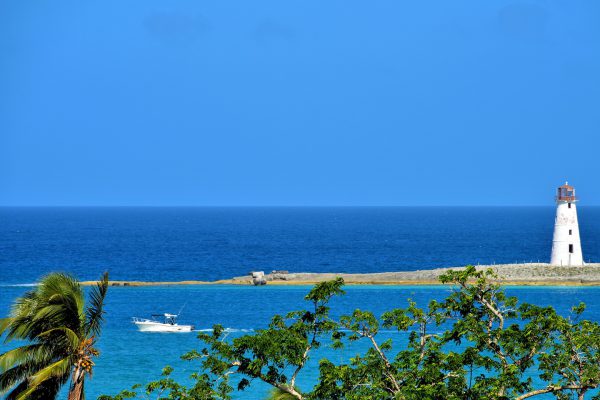
The lighthouse on Paradise Island at the west entrance of Nassau Harbor was built in 1817, making it the oldest in the West Indies. Originally called the Hog Island Lighthouse, the 69 foot structure has a whitewashed, brick base with a red lantern. For a few years prior to its installation, Fort Fincastle at the top of Bennett’s Hill had the only beacon to help sailors navigate at night. That function was transferred to the neighboring Water Tower when it was built in 1928. Lighthouse aficionados might also enjoy seeing the 56 foot East End Point on New Providence Island.
Nassau Harbour Lighthouse, Paradise Island, The Bahamas Enlarge/Slideshow See On Map Directions
The first lighthouse at Needham’s Point was erected in 1855. It was replaced in 1886 with this 43 foot, white octagonal tower. The stationary beacon provided nighttime navigation for ships approaching Carlisle Bay. After becoming inactive, the historic lighthouse was incorporated onto the grounds of the Hilton Barbados Resort.
Needham’s Point Lighthouse, Bridgetown, Barbados Enlarge/Slideshow See On Map Directions
This classic, red and white cast-iron lighthouse was displayed at The Great Exhibition in 1851. This event at the Crystal Palace was the equivalent to the first World’s Fair. The following year, the 89 foot lighthouse was shipped to Barbados and reassembled at the southernmost part of the island. It is sometimes called Gordon’s Lighthouse in honor of the architect, Alexander Gordon. This oldest Barbados lighthouse is featured on the five cent Barbadian coin.
South Point Lighthouse, Lighthouse Dr, Green Garden, Barbados Enlarge/Slideshow See On Map Directions
The East Point Lighthouse is aptly named for its location near the easternmost coast of the island in Saint Philip Parish. The 97 foot, conical tower with a black lantern was erected in 1875 on the former Golden Grove Plantation. The government-owned land is now called Ragged Point, as is the small village. Hence, the light is often called the Ragged Point Lighthouse. You can walk around the grounds but cannot climb up the still active lighthouse.
East Point Lighthouse, Ragged Point, Barbados Enlarge/Slideshow See On Map Directions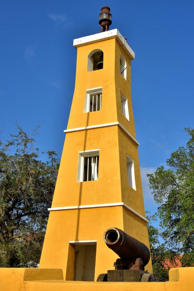
Fort Oranje was built by the Dutch during the 17th century. The fortress was rebuilt almost 200 years later and armed with cannons from a British Navy warship that ran aground off the coast. Those guns were reclaimed by the British a few years later (1807 – 1816) and the four current ones were added. Fort Orange served as the governor’s home until 1837. In 1868, a wooden lighthouse was constructed. It was replaced with this 32 foot, stone version in 1932. This National Monument and Bonaire’s oldest building is now a courthouse. The tower serves as the harbormaster’s office. The fort’s name honors the Netherland’s House of Orange royal family.
Kaya C.E.B. Hellmund & Plaza Wilhelmina, Kralendijk, Caribbean Netherlands Enlarge/Slideshow See On Map Directions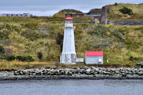
Within eyesight of the Halifax Seaport, and directly across from the cruise ship terminal at Pavilion 22, is Georges Island. The British built a fort here in 1750 at the outbreak of the Father Le Loutre’s War. The clash pitted Great Britain against the Miꞌkmaq (First Nations people) and Acadians (from a New France colony). This site was also used to contain prisoners of war. In 1798, Prince Edward (the future father of Queen Victoria) built Fort Charlotte (named for his mother). A subsequent one was constructed during the American Civil War. The citadel remained in service through WWII. The islet has had several names. The current one – Georges Island – is a tribute to George II, the King of Great Britain from 1727 until 1760. Unfortunately, Georges Island is not open to tourism. This 57 foot concrete lighthouse dates from 1917. The original one was installed in 1876.
Georges Island Rd, Halifax, NS B3K 5M7, Canada Enlarge/Slideshow See On Map Directions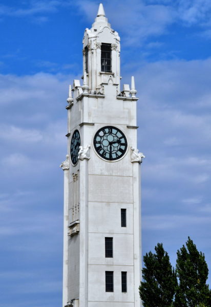
Montreal’s equivalent of Big Ben is the Clock Tower located at the end of Victoria Pier. This elegant beauty was designed by Paul Leclaire. Tour de l’Horloge has served several purposes since 1922. The 148 foot tower is a lighthouse marking the entrance to the Old Port. Generations of sailors have relied on the clock’s legendary accuracy. This is a monument to sailors killed during WWI. And, the window at the top of 192 stairs is a wonderful observation platform.
1 Clock Tower Quay St, Montreal, QC H2L 5C1, Canada Enlarge/Slideshow See On Map Directions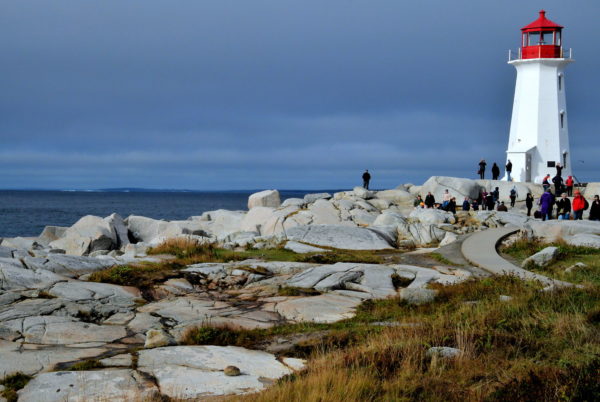
Peggy’s Cove is a quintessential fishing village – small, quaint and picturesque – about a 45 minute drive from downtown Halifax. Perched atop slabs of exposed gray granite is Peggy’s Point Lighthouse. This is the most famous of the 150 lighthouses still operating in Nova Scotia. The white, octagonal tower stands 49 feet at the end of a headland along the coast of the Atlantic Ocean. It was built in 1915 to replace the original from 1868. Expect crowds of camera-carrying tourists. Locals claim this is among the most photographed sites in Atlantic Canada.
185 Peggys Point Rd, Peggys Cove, NS B3Z 3S1, Canada Enlarge/Slideshow See On Map Directions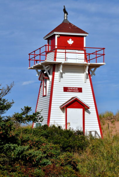
You are now in Prince Edward Island National Park. The park stretches for 37 miles along the north coast. This scenic area is easy to explore by driving along Gulf Shore Parkway East. PEI National Park maintains magnificent beaches, miles of hiking trails, campgrounds and historic sites. There are also attractions appealing to summertime locals and tourists. This is the Covehead Harbour Lighthouse. The origin dates back to 1879 when two masts were fitted with lights at the mouth of the harbor. The current version of the 26.9 foot high light was built in 1975.
1530 Gulf Shore Pkwy E, York, PE C0A 1P0, Canada Enlarge/Slideshow See On Map Directions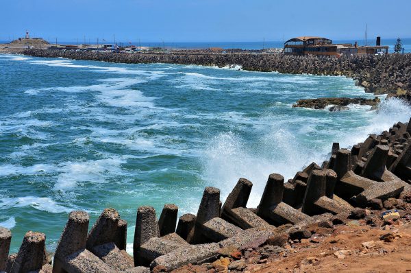
At the end of this breakwater along Península Alacrán is a 75 foot lighthouse. The navigation station has been operational since 1913. If you notice the pounding Pacific surf, you are not alone. The city hosts the Arica Chilean Challenge sponsored by the World Bodyboarding Tour. The six to ten foot waves attract the world’s best bodyboarding riders to compete in this annual two-day event.
Restaurant Maracuyá San Martín 321, Arica, Región de Arica y Parinacota, Chile Enlarge/Slideshow See On Map Directions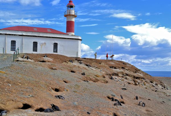
Lighthouses are typically a major draw for tourists. However, the Faro Isla Magdalena is a distance second attraction compared to the thousands of Magellanic penguins surrounding it. This white, cylindrical beacon with a bold red stripe and roof became operational in 1902. It was manned by a keeper who lived in the white house until the light became automated during the 1950’s. After a renovation in 1995, the building serves as an office for staff who manage the penguin reserve.
Magdalena Island, Magallanes y la Antártica, Chilena Region, Chile Enlarge/Slideshow See On Map Directions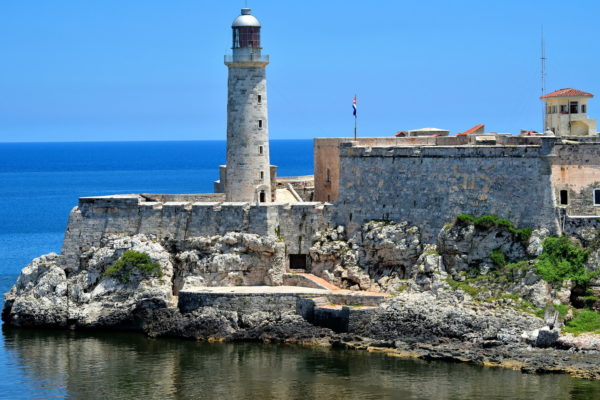
Three fortresses were built during the 16th and early 17th centuries to protect Havana. The Fuera, Morro and Punta castles are featured in Havana’s coat of arms. This is Castle of Tres Reyes del Morro located at the north entrance of the harbor. Construction of the Castle of the Three Kings lasted 41 years. When it was finished in 1630, El Morro was considered impenetrable. History proved that assumption wrong. The 82 foot tall Faro Castillo del Morro was built in 1845, making it the oldest of Cuba’s approximate 50 lighthouses.
Parque Histórico Militar Morro-Cabaña, La Habana, Cuba Enlarge/Slideshow See On Map Directions
If you are on a budget, the good news about Casa de Campo is you do not need to be a guest of the resort or a villa owner to experience its amazing amenities. For a small fee, you can visit Altos de Chavón, the marina and Minitas Beach. These three locations make for a perfect, one-day excursion. This lighthouse is at the end of the marina pier attached to the SBG Restaurant. The menu features Mediterranean cuisine. The exquisite seascape of the Caribbean from the outdoor seating is free.
Casa De Campo La Marina, La Romana 22000, Dominican Republic Enlarge/Slideshow See On Map Directions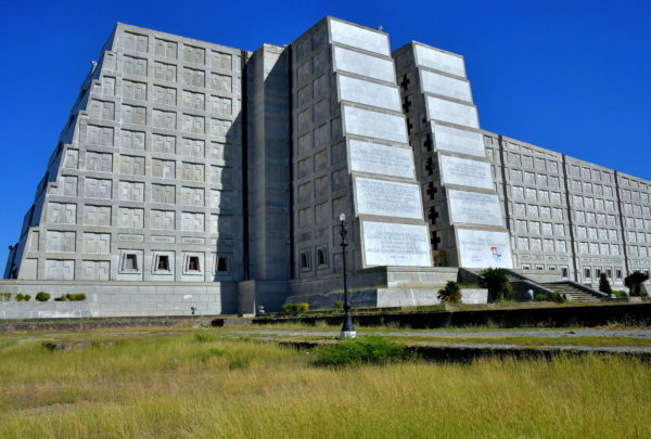
Faro a Colón opened in 1992 as part of the quincentennial anniversary of the discovery of the Americas. Inside is an elaborate mausoleum reported to contain relics of Christopher Columbus (although the explorer’s body has proven to be buried in the Seville Cathedral in Spain). There is also a museum with exhibits from each of the countries in the Americas. The Columbus Lighthouse is probably the largest lighthouse you will ever see. The concrete structure designed by Joseph Lea Gleave measures 680 feet long and 195 feet wide. Faro a Colón is located in the Santo Domingo Este Municipality. This is a short distance by car from the Colonial Zone.
Faro a Colón, Av. Mirador del Este, Santo Domingo Este 11604, Dominican Republic Enlarge/Slideshow See On Map Directions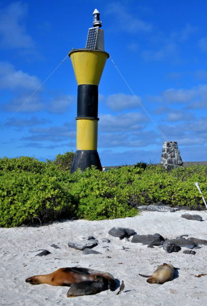
Your small tour group will assemble near this beacon after everyone is finished taking photos of the wildlife within the first hundred feet of the landing site. Your two-hour excursion will follow a two-mile loop. Although the island is mostly flat, the hiking trail is very uneven and littered with rocks of every size. So being physical fit and vigilant of your steps are essential. While you are waiting for stragglers, enjoy seeing these napping sea lions.
Punta Suárez, Española Island, Ecuador Enlarge/Slideshow See On Map Directions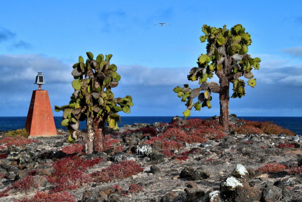
The walking trail on Plaza Sur reaches its peak elevation near an orange beacon. From this promontory, you have a great view of Santa Cruz to the east, North Plaza Island to the north and Gordon Rocks in the west. You can hear the crashing waves below the precipice and watch the birds circling overhead. This experience is enthralling. You can follow the path to the headland before reluctantly retracing your steps back to the awaiting boat.
Isla Plaza Sur, Ecuador Enlarge/Slideshow See On Map Directions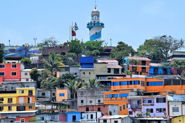
This 61.5 foot lighthouse with the blue and white stripes at the 197 foot summit of Santa Ana Hill is the symbol of Guayaquil. The initial Spanish settlement was founded in the 1530s. After being destroyed twice by indigenous people, it relocated here at the base of Little Green Hill in 1547. Since then, Guayaquil has become Ecuador’s largest city with over two million residents. From the light’s observation deck, you can enjoy a panoramic view of many of the landmarks in the Old and New Towns plus the Guayas River.
Diego Noboa y Arteta, Escalon 444 Cerro Santa Ana, Guayaquil 090313, Ecuador Enlarge/Slideshow See On Map Directions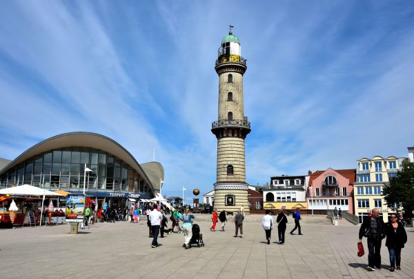
The two famous landmarks in Warnemünde stand side-by-side along the Seepromenade pedestrian walkway parallel to the Baltic Sea. After getting a bite to eat in the uniquely shaped Teepott, consider exploring the lighthouse. Guided tours are conducted by volunteers from the Warnemünder Lighthouse Society. If this light looks vaguely familiar, then you probably saw the marketing material for the 2010 movie Shutter Island starring Leonardo DiCaprio.
Seepromenade 3, 18119 Rostock, Germany Enlarge/Slideshow See On Map Directions
When a restaurant owner’s name is Giuseppe Gatta, you expect to find a menu with Italian food. When the eatery is housed inside a lighthouse, you expect a great seaside location. You get them both at the Lighthouse Restaurant. You can also order great Mediterranean and local seafood for lunch or dinner while enjoying the Caribbean view from their outdoor dock seating.
2114 Bodden Town Rd, Cayman Islands Enlarge/Slideshow See On Map Directions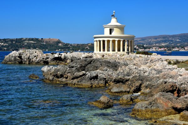
The Lighthouse of Saint Theodore was constructed at the command of Charles Napier while he was the British High Commissioner of Kefalonia during the early 19th century. After it was destroyed in 1953, the Fanari was rebuilt within seven years following its original circular design surrounded by 20 Doric columns. The popular light stands 26 feet tall at the end of a short, rocky peninsula.
Lantern St. Theodore Argostoli 281 00, Greece Enlarge/Slideshow See On Map Directions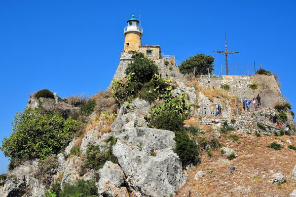
The Byzantines selected the highest peak of the peninsula to construct their early fortifications. They called it Sea-Tower. In 1822, the Greeks built their country’s first stone lighthouse – Paleo Enetiko Frouno – on the other peak called Land Tower. It is a hike up the Castel a Terra (Castle Near the Land) summit to reach the top but the views of the city and bays are worth the climb. The light is nearly 210 feet tall.
Agoniston Politechniou, Kerkira 491 00, Greece Enlarge/Slideshow See On Map Directions
Grenada attracts boats of all sizes, from cruise ships to small fishing boats. So, it is surprising to learn about the dearth of lighthouses on the island. The first was a small beacon built on Fort George at the end of the 19th century. It has been inactive since 2017. The second was installed at Pointe Saline in 1904. After the 18 foot lighthouse was decommissioned in the 1980s, it was moved to the airport for ornamentation. Prickly Point Lighthouse is the only active navigation aid. The 98 foot, green tower is installed at the tip of Lance aux Epines Peninsula. The lighthouse is privately owned and not open to tourists.
L'ance aux Epines Lighthouse, Lance aux Epines, Grenada Enlarge/Slideshow See On Map Directions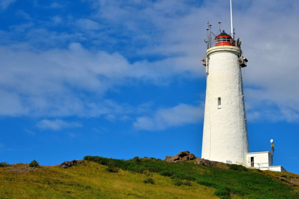
There are about 120 lighthouses along Iceland’s 3,088 mile coastline. The country’s first was built in 1878 on nearby Valahnúkur Point. After it was destroyed by an earthquake, this replacement was raised on Bæjarfell Hill. The concrete, cylindrical tower of the Reykjanes Lighthouse is capped with a red lantern. Together they stand 102 feet yet are 226 above sea level. Ships sailing in the North Atlantic can see the beacon up to 22 nautical miles before reaching the southwest coast of Iceland.
Reykjanes Lighthouse, Islandij, Reykjanes, Iceland Enlarge/Slideshow See On Map Directions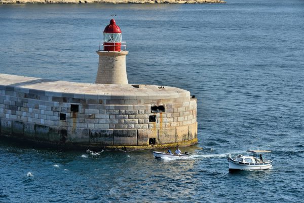
Ricasoli Lighthouse stands about 100 feet on a breakwater along the eastern entry of the Grand Harbour in Malta. The namesake is Fort Ricasoli. The defense was built by the Knights of St. John at the end of the 17th century. It is located next to this stone pier in the town of Kalkara. The beacon was erected in 1908.
Mediterranean Street Valletta, Malta Enlarge/Slideshow See On Map Directions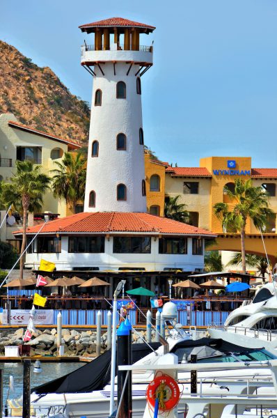
There are numerous lighthouses in the Mexican state of Baja California Sur that aid navigation in the Sea of Cortés and the Pacific Ocean. There are nine lights within the Los Cabos Municipality. But this 65 foot ornamental light adjacent to the Hotel Plaza Las Glorias at the Cobo San Lucas Marina was built as a beacon to entertain tourists.
Plaza Tesoro Local G4, Tesoro, Marina, 23040 Cabo San Lucas, Baja California Sur, Mexico Enlarge/Slideshow See On Map Directions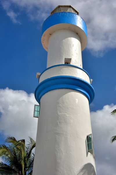
Directly across from the Punta Langosta Pier is a 49 foot lighthouse with the same name: El Faro de Punta Langosta. In Spanish, this means Lobster Point. This station along the waterfront was established in 1906. It was deactivated in 2000 when the Punta Ealetita was built. Since then, the old cylindrical concrete light received fresh paint and welcomes arriving cruise ship passengers.
Av. Rafael E. Melgar 599, Centro, 77600 San Miguel de Cozumel, Q.R., Mexico Enlarge/Slideshow See On Map Directions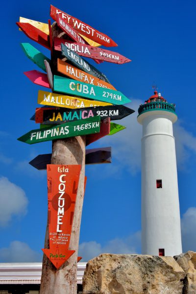
Faro de Celarain is located on the Punta Sur Promontory. The 85 foot lighthouse was built in 1934 to help ships navigate the reefs along the southernmost tip of Cozumel. The 1908 keeper’s house is now a small nautical museum. Climbing the 133 steps provides a panoramic view of Punta Sur Park and the Caribbean Sea. It is easy to find. Just triangulate the distances shown on this way signpost.
Museo De Navegacion San Miguel de Cozumel, Q.R., Mexico Enlarge/Slideshow See On Map Directions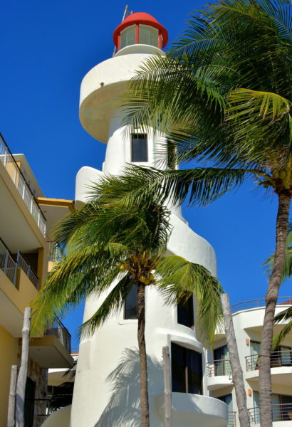
El Faro (Spanish for lighthouse) was privately built as an active light. It stands 56 feet in front of the beach at Playa del Carmen. Below its red lantern is a staircase spiraling around its cylinder shape. This landmark is adjacent to the El Faro Condo-Hotel.
Residences El Faro, Calle 10 Norte, 77710 Playa del Carmen, QROO, Mexico Enlarge/Slideshow See On Map Directions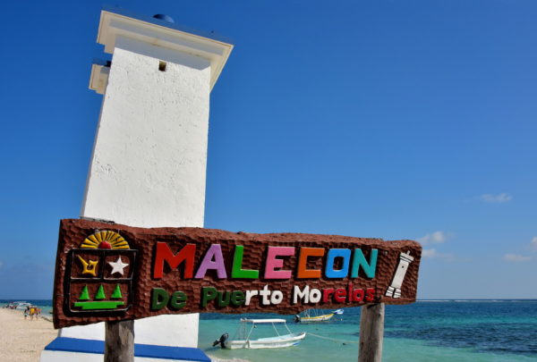
Although this leaning lighthouse has become the symbol for Puerto Morelos, it was not created as a marketing prop next to the pier (malecon). This 33 foot beacon was built in 1946 to replace the original light erected in 1905. On September 16, 1967, the high waves and sustained winds exceeding 100 m.p.h. from Hurricane Beulah weakened its foundation causing it to tilt. The locals then named it Faro Inclinado meaning Inclined Lighthouse.
Faro Inclinado, Puerto Morelos 77580, QROO, MX Enlarge/Slideshow See On Map Directions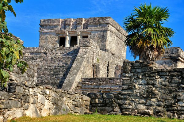
El Castillo controls a commanding position within Tulum. This massive staircase faces west toward the central square of the ancient Mayan civilization. Religious ceremonies were held on the platform at the base of the temple’s columned entrance. The eastern side hugs a 40 foot limestone cliff along the shore of the Caribbean Sea. Historians believe two fires were lit from the top of the 40 foot pyramid. The beacons helped canoers navigate the dangerous reefs at night. This is why The Castle is often called The Lighthouse.
Carretera federal 307 Cancún - Chetumal Km 230, 77780 Tulum, Q.R., Mexico Enlarge/Slideshow See On Map Directions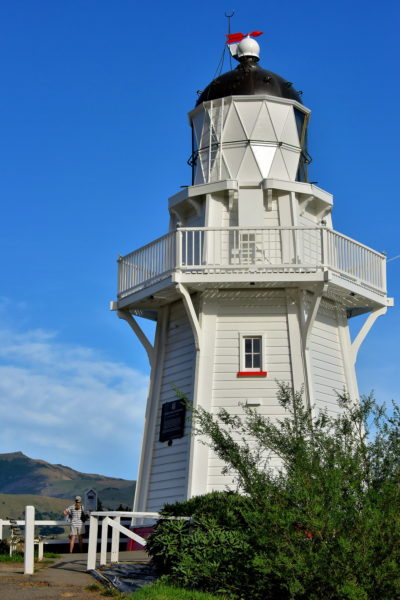
This octagonal, 28 foot wooden lighthouse first flashed its beacon on January 1, 1880. Akaroa Head Lighthouse was maintained by a keeper until automated in 1977. A century after it was built, it was moved to the current position at Cemetery Point. The original location was at Akaroa Head flanking the mouth of Akaroa Harbour on Banks Peninsula. To visit this former site and the scenic Haylocks Bay, follow Lighthouse Road from Akaroa to the end of the promontory. This .3 mile trip by four wheeler or walking is also called the Akaroa Head Scenic Reserve Walk.
Akaroa Lighthouse, Beach Rd, Akaroa 7520, New Zealand Enlarge/Slideshow See On Map Directions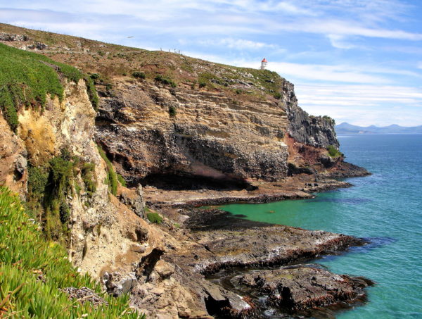
Whether you drive to the end of Otago Peninsula or sail by it, you cannot miss the splendor of Taiaroa Head. At the peak of this promontory is the Taiaroa Head Lighthouse. Its beacon has helped sailors navigate the Pacific Ocean’s coastal waters since 1864. More exciting is viewing 200 northern royal albatrosses. This endangered, enormous seabird has a wingspan of eight to ten feet. This is the only mainland colony in the Southern Hemisphere. Other wildlife residents of this nature reserve are little blue and yellow-eyed penguins, Stewart Island shags, New Zealand sea lions plus dusky dolphins and migratory whales.
Waiwhakaheke Seabird Lookout, Taiaroa Head, Harington Point, 9077, New Zealand Enlarge/Slideshow See On Map Directions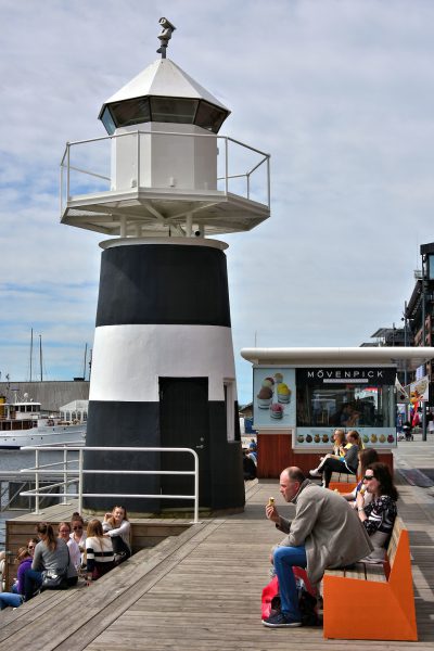
This lighthouse stands along a pedestrian walkway called Strandon meaning Beach. It is the main boardwalk facing the Pipevika harbor in the Aker Brygge district. Locals and tourists flock to this area for shopping, restaurants and entertainment. Another favorite pastime is to leisurely view the waterfront while enjoying a Mövenpick ice cream cone.
Bella Bua Stranden 7, 0250 Oslo, Norway Enlarge/Slideshow See On Map Directions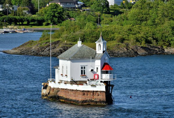
Dyna Light is perched on a stone islet resembling a ship bow. The lantern, which reaches a height of 40.5 feet, looks like a church steeple except it contains a fog horn instead of a bell. This navigational beacon was built in 1875 about 220 yards off the Bygdøy coastline. This is a couple miles away from Oslo. When Dyna Fyr was renovated in 1992, the white wooden keeper’s house was converted into a banquet and special event facility. However, it is still an active lighthouse.
[59.894875 10.688419] Enlarge/Slideshow See On Map Directions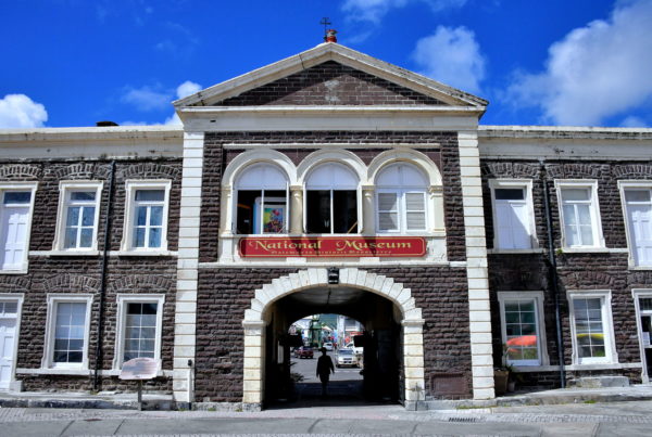
The former Treasury Building was constructed from volcanic rock and Barbados limestone circa 1900. The arch was called the Gateway to the Island because it was the entry to the capital city from the old port. Above the pediment is a beacon that acted as a lighthouse for nearly a century. The heritage building is now home to the St. Christopher National Trust. The institution manages the National Museum. This is an archive of the country’s history and culture dating back to the Indigenous people who lived on the islands before the first European settlers. The exhibits are fascinating to visit.
National Museum, Bay Rd, Basseterre, St. Kitts & Nevis Enlarge/Slideshow See On Map Directions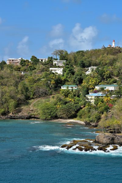
Vigie Lighthouse was established in 1883. The current white, cylindrical tower with a red lantern was rebuilt in 1915. Although only 36 feet tall, its 320 foot elevation atop Vigie Peninsula makes the flashing lights easy to spot at sea. This lighthouse still serves a critical role in managing Castries Harbor. The keeper coordinates the arrival and departure of major ships and dispatches the assistance of tug boats.
Vigie Lighthouse Beacon Rd, St. Lucia Enlarge/Slideshow See On Map Directions
Fans of lighthouses will love visiting this one shaped like a red horse. Iho Hang visually dominates the west breakwater leading into Iho Harbor. This unique, 39 foot beacon – along with an identical white horse deungdae (Korean for lighthouse) on the opposite side – is located on Iho Tewoo Beach. This 500 foot stretch of sand along the Korea Strait is a popular spot for the locals to swim, sun and fish during the summer when the temperature averages in the 80s° F.
375-18 Ihoil-dong, Cheju, Jeju-do, South Korea Enlarge/Slideshow See On Map Directions
The location of San Sebastián Castle reaches out into the Atlantic Ocean. The Muslims and Venetians both took advantage of this position by building watchtowers. The first lighthouse was established in 1776. A new one was added in 1855 and demolished in 1898. It was replaced with this 135 foot skeletal tower in 1913 designed by Rafael de la Cerda. The Castillo de San Sebastián Lighthouse remains operational.
Castillo de San Sebastián, 11002 Cádiz, Spain Enlarge/Slideshow See On Map Directions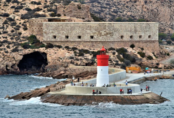
As the capabilities of naval warfare evolved, so did the defenses of Cartagena’s harbor. Christmas Fort began with a hexagonal tower in the 16th century, became a coastal battery in 1740 and was significantly expanded in 1860. At its peak, the fort was armed with 16 pieces of artillery. Many of them are still in place within the casemates. Fuerte de Navidad was abandoned in 1941. It is now a tourist attraction. During your visit, you will witness the lifestyle of the men stationed here. You can reach Christmas Fort by car or tourist boat. In the foreground is the 49 foot tall Dique de la Navidad Lighthouse. The Christmas Lighthouse was built on the breakwater in 1892.
Pasaje Faro Navidad, 2, 30394 Cartagena, Murcia, Spain Enlarge/Slideshow See On Map Directions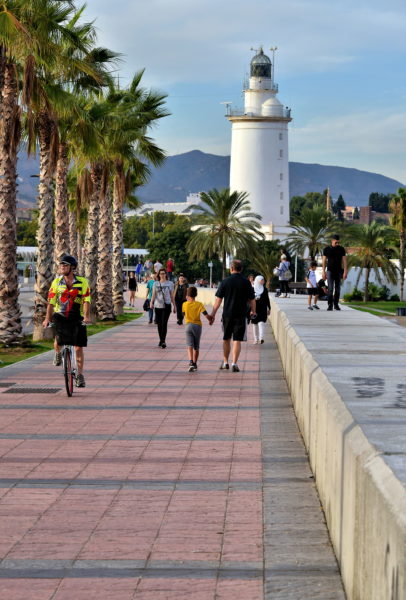
Sea captains have been aided by a lighthouse at the Port of Málaga since 1717. A century later, it was replaced with La Farola de Málaga. This means The Lamp of Málaga. The light suffered from an earthquake in 1884, was heavily damaged during the Spanish Civil War (1936 – 1939) and has been pummeled by countless storms. Each time La Farola was repaired or rebuilt. This beloved, 108 foot icon of the city punctuates Muelle Uno. It is also near Muelle de Levante, the main cruise ship terminal.
Paseo de la Farola, 18, 29016 Málaga, Spain Enlarge/Slideshow See On Map Directions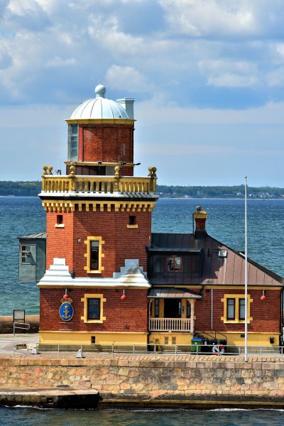
The Helsingborg Lighthouse stands 23 feet on a pilot station at the entrance to the city’s Inner Harbor on a breakwater called Parapeten. This red brick, octagonal tower with its blue lantern and balustrade was built in 1889 based on a design by architect John Höijer. It is still active.
Parapeten 2, 252 67 Helsingborg, Sweden Enlarge/Slideshow See On Map Directions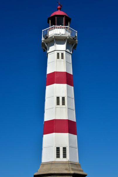
This classic looking, red and white banded lighthouse (fye in Swedish) was constructed in 1878. The Inre Hamn aided ship navigation for about 105 years before being decommissioned in 1983. The octagon-shaped, cast iron tower stands 66 feet tall. The light is located at the mouth of the Inner Harbor next to the University Bridge which opened in 2004.
Universitetsbron, 211 19 Malmö, Sweden Enlarge/Slideshow See On Map Directions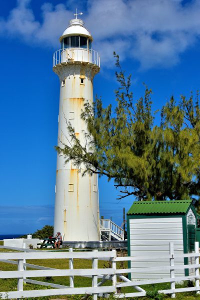
This 60 foot, cast iron lighthouse was designed by Alexander Gordon, built in London and assembled along the northern coast of Grand Turk in 1852. The beacon’s Argand oil lamps and then Fresnel lens were managed by keepers for 120 years before it was automated in 1972. This popular landmark is a historic site protected by the Turks and Caicos National Trust.
Historic Lighthouse, Lighthouse Rd, Grand Turk Cockburn Town TKCA 1ZZ, Turks and Caicos Islands Enlarge/Slideshow See On Map Directions