My goal is to find and photograph some of the best beaches in the world. Here is a small sample. You’ll find many, many more in my individual galleries by country and city.
My goal is to find and photograph some of the best beaches in the world. Here is a small sample. You’ll find many, many more in my individual galleries by country and city.
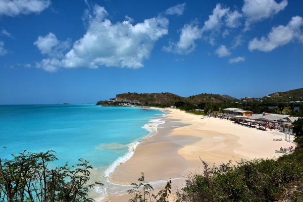
It would take you a full year to spend one day enjoying each of Antigua’s 365 beaches. If your vacation to this West Indies island is not that long, then consider adding Darkwood Beach to your short list of places to wear your bathing suit and sunglasses. One look is worth a thousand superlatives.
Darkwood Beach, Valley Rd, Antigua & Barbuda Enlarge/Slideshow See On Map Directions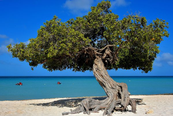
When you Google Aruba, you will immediately see numerous photos of this twisted, windswept tree. The locals call it divi-divi, the Arawak name is watapana, the scientific classification is caesalpinia coriaria and the island considers it their national tree. This iconic symbol of Aruba is bent towards the Caribbean Sea along the beautiful Eagle Beach. Don’t miss it!
Divi Tree, Eagle Beach, Aruba Enlarge/Slideshow See On Map Directions
2,300 feet of golden sand forms the northern shore of Burnie. West Beach extends from the port at Blackman Point and ends here at the base of a hill where Makers’ Workshop is located. Locals love it for sunning and swimming, especially at high tide when waves tend to be moderate. The rocks in the background form a circular headland called Parsonage Point. It is a favorite habitat for eudyptula minors. What’s that? Fairy penguins. These blue-colored, flightless seabirds stand only about a foot high. Just after sunset from October through March, you can watch them emerge from the water and waddle back to their burrows. The best vantage point is from the Little Penguin Observation Centre.
West Beach, 3 North Terrace, Burnie TAS 7320, Australia Enlarge/Slideshow See On Map Directions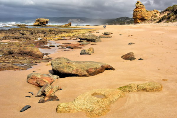
Most tourists to Aireys Inlet only visit the lighthouse. Or they stretch their legs along the Cliff Top Walk or Lighthouse Precinct Walk before resuming their drive on the Great Ocean Road. That is perfect. It allows you to treasure this exquisite Aireys Inlet Beach in solitude. Defining this 1,640 foot stretch of rock-strewn sand is an eroding red bluff plus sandstone formations. These artworks of nature were created by millenniums of waves and wind. At low tide, rock pools form and become a haven for tiny sea creatures. This gorgeous seascape is not visible from the parking lot at the end of Eagle Rock Parade. It unfolds after walking a short distance around a large pinnacle at the end of a headland. The beach is part of the Lorne-Queenscliff Coastal Reserve.
Reserve Rd & Inlet Cres, Aireys Inlet VIC 3231, Australia Enlarge/Slideshow See On Map Directions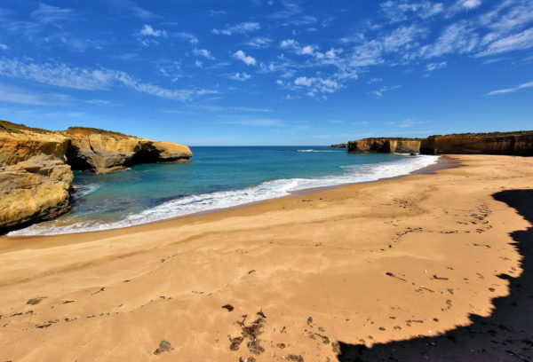
Most people visiting London Arch (previously London Bridge) never venture beyond the primary overlook. That is totally understandable. At this point in your Great Ocean Road adventure, you might be taking one remarkable rock formation after another a bit for granted. But consider following the path less traveled. On the left (east) of the main walkway is a narrow trail that winds down to this beach. The amphitheatric scenery is serene and sensational.
London Bridge Rd & Great Ocean Rd, Peterborough VIC 3270, Australia Enlarge/Slideshow See On Map Directions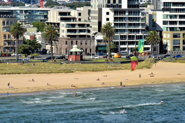
International cruise ships dock at Station Pier in the City of Port Melbourne. This is also the terminal for the Spirit of Tasmania, a daily service to the island state 150 miles south of the mainland and across Bass Strait. When you disembark from your passenger ship, this bayside shoreline is only a gangplank away. Port Melbourne Beach is perfect for sunning, swimming and kitesurfing. There are also good restaurants and cafes along Beach Street. Melbourne’s city center is about four miles away. Typically, your ship will provide a low-cost, round-trip shuttle into the Arts Precinct. Alternative transportation into CBD (downtown) included tram or bus (both Route 109) and taxi.
Port Melbourne Beach, Beach St, Port Melbourne VIC 3207, Australia Enlarge/Slideshow See On Map Directions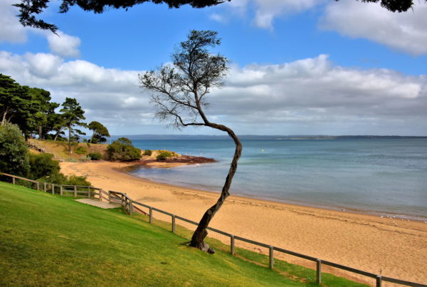
The finest attribute of Cowes is this beach. Unlike the incessant waves on the Bass Strait coast, the water on the northern shore is calm and inviting when the wind is from the south. On a clear day, you can see Mornington Peninsula and French Island, two of Cowes’ neighbors in Western Port Bay. Equally enticing are the town’s waterfront promenade and picnic tables on the foreshore. When the sun is shining, families favor the manicured lawns while sunbathers relax on the pristine sand.
Cowes Beach, The Esplanade, Cowes VIC 3922, Australia Enlarge/Slideshow See On Map Directions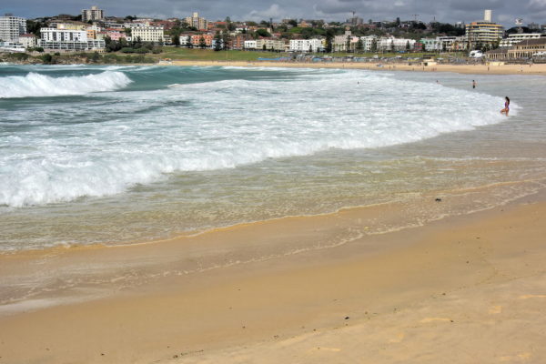
If you want to escape the bustle of Sydney and enjoy a day of sun, surf and sunshine, then Bondi Beach is the destination for you. This crescent-shaped, six mile stretch of sand is very popular among Aussies. The name means “water breaking over rocks” in the Aboriginal language. The northern end has the gentlest waves and is favored by swimmers.
Bondi Beach, Sydney NSW 2026, Australia Enlarge/Slideshow See On Map Directions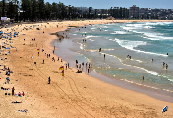
This crescent-shaped, .8 mile stretch of seashore is always listed among the best of Sydney’s 100 plus beaches. Typically, Manly Beach is rated number one. During the 19th century, the Port Jackson & Manly Steamship Company marketed this haven as, “Seven miles from Sydney and a thousand miles from care.” What a perfect description! Less crowded but equally enjoyable stretches of sand are Freshwater Beach just north of Queenscliff Head and Shelly Beach to the south at the end of Marine Parade.
Manly Beach, N Steyne, Manly NSW 2095, Australia Enlarge/Slideshow See On Map Directions
Reality consistency gets in the way of having fun. The remedy? Book a short flight or cruise to Grand Bahama. Then don your beach apparel sans shoes and go for a barefoot stroll with your best friend. Feel the warmth. Smell the ocean. Listen to the surf. Soon real life disappears as you savor your private paradise.
Sea Gate Ln, Freeport, The Bahamas Enlarge/Slideshow See On Map Directions
Great Stirrup Cay’s tropical climate is perfect for a day at the beach regardless of when you arrive. The average air temperature in the winter months is 77° Fahrenheit and above 80° during the rest of the year. Not surprising, the water temps are the same yet may feel warmer because of the shallow water formed by the breakwaters. Equally important is abundant sunshine. The island experiences overcast conditions less than five days a month.
Great Stirrup Cay, The Bahamas Enlarge/Slideshow See On Map Directions
If you like water, you will love Atlantis Paradise Island. For starters, the property offers 17 swimming pools. The 141 acre Aquaventure features a mile long water ride, five themed water slides, 14 lagoons, more than 50,000 marine animals plus a marina. With all of that activity, the adjacent Paradise Beach is virtually empty. It is a perfect place for a relaxing stroll all the way to the lighthouse on the western edge of Paradise Island.
One Casino Drive, N-3728, Paradise Island, Bahamas Enlarge/Slideshow See On Map Directions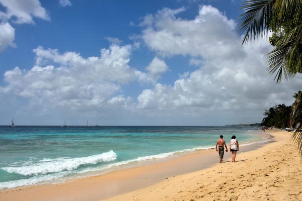
Your road trip from Bridgetown along the western coast begins at Paynes Bay. It is one of the best beaches in western Barbados. Paynes Beach is located along the “Platinum Coast” in the middle of Saint James Parish. This area also has the island’s major golf courses (it is where Tiger Woods got married) and is lined with very exclusive resorts for the rich and famous. If you see someone resembling Robyn Fenty, say hello because she probably is Rihanna. She has a home at Sandy Lane and was born in the neighboring parish of Saint Michael.
Hwy 1 & White House Terrace, Barbados Enlarge/Slideshow See On Map Directions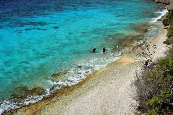
Conduct online research of the best scuba diving locations in the world and Bonaire will consistently rank toward the top. Among the island’s 86 dives sites, 1000 Steps is considered one of the best of the best. The underwater scenery is spectacular! Snorkelers enjoy it too. However, its name is a misnomer: there are only 67 limestone-carved steps down to this beach. So why do they call it 1000 Steps? After you carry your gear back up to the car, your lungs will tell you the answer.
1000 Steps, Queen's Highway, Rincón, Caribbean Netherlands Enlarge/Slideshow See On Map Directions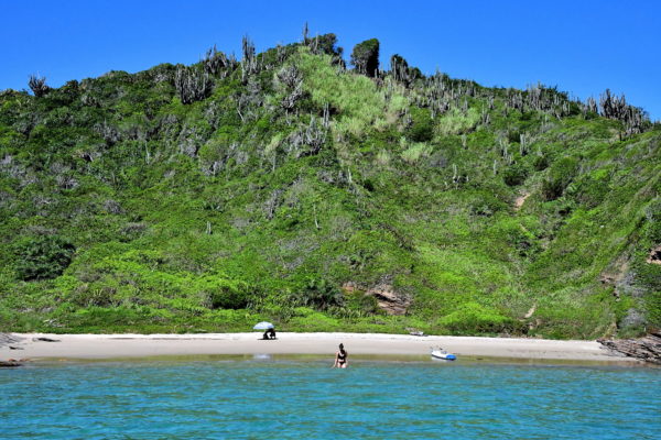
Now imagine a small strip of secluded sand defined by a lush green hillside and warm turquoise water. The sun has been shining on only the two of you since you paddled up in a kayak. You go for a relaxing swim. You hold hands while sitting beneath a beach umbrella. Your smiles are only interrupted by kisses. This is the tropical paradise you have always dreamed about. So, what would you call this sensuous place? The perfect name of course is Praia dos Amores meaning Beach of Lovers.
Praia dos Amores, R. Maria Joaquina - Búzios - RJ, 28950-000, Brazil Enlarge/Slideshow See On Map Directions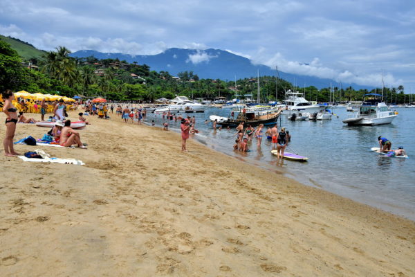
Ilhabela has 40 beaches along its 85 miles of coastline. That should be enough to satisfy any sun worshiper. The western shore is almost a continuous ribbon of sand. The closest beach to the Historic Center is Praia do Pereguê in the Saco da Capela neighborhood. A lovely promenade starts near the main pier and hugs the waterfront for miles. Or claim your spot at Pereque Beach while relishing the tropical climate. It has every amenity you need. Among the best beaches on the island – and some claim in Brazil – are Baia de Castelhanos, Julião, Jabaquara, Bonete, Pedra do Sino and Pinto.
Av. Pedro de Paula Moraes, 151 - Saco da Capela, Ilhabela - SP, 11630-000, Brazil Enlarge/Slideshow See On Map Directions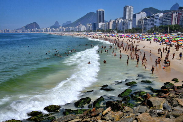
One of the most famous beaches in the world is Copacabana. This 2.2 mile stretch of sand facing the ocean is visually bookended by Sugarloaf Mountain in the north and Fort Copacabana in the south. Activities are simple: swimming, sunning and socializing. More active folks use the volleyball nets or football courts, run or jog, or strut their stuff on exercise equipment. Copacabana is also the site of New Year’s Eve fireworks. Two million people show up to watch the third largest display in the world.
Praia de Copacabana - Copacabana, Rio de Janeiro - RJ, 22020-030, Brazil Enlarge/Slideshow See On Map Directions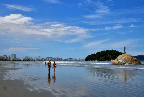
At the east end of Itararé Beach is a large rock with a statue. This is Pedra da Feiticeira or the Stone of Sorrow. According to legend, a witch-like woman was impregnated here by a sailor. He promised to return but never did. One day she believed he was sailing by in a boat. When she swam out, she was drowned in the current. This marks the beginning of about 4.5 miles of near-continuous sand along the shores of Santos. The seven beaches range from Praia José Menino in the west (behind the strolling couple) to Ponta da Praia in the east at the mouth of the Santos Port. Parallel to the coastline is a beachfront garden measuring over 17,500 feet long. According to the Guinness Book of Records, it is the world’s largest.
Pedra Da Feiticeira, Praia Itararé - Itararé, São Vicente - SP, 11320-200, Brazil Enlarge/Slideshow See On Map Directions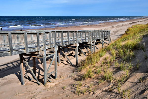
There are seven beaches in Prince Edward Island National Park. They all face the Gulf of St. Lawrence. The shoreline is defined by windswept dunes and red sandstone mounds. Most are easily accessible from Gulf Shore Parkway East by wooden boardwalks. This is Brackley Beach, one of the most popular. The wide and long stretch of sand is magical, a perfect place to become mesmerized by the rolling waves. Amenities include washrooms, a canteen and lifeguards. There is also ample parking to accommodate even late risers. Active souls will enjoy biking, walking or running along the 7.75 mile Gulf Shore Way. Another favorite spot to idle away a summer day is Cavendish Beach.
Brackley Beach, Gulf Shore Pkwy E, Lot 33, PE C0A 1X0, Canada Enlarge/Slideshow See On Map Directions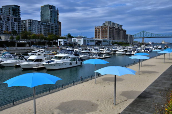
Summers seem too short in Montreal. So, when the temperatures reach the 70s and 80s Fahrenheit from June through August, the locals are eager to bask in the sunshine. The only urban choice for sun worshipers is Clock Tower Beach at the Old Port. This strip of manmade sand runs parallel to a small boat harbor. An attached bar keeps everyone in a lively mood. Misting stations keep everyone cool. There are ten other beaches but most require transportation from Old Montreal. A few favorites are Oka Beach (featuring family and clothes-optional sides), Jean-Doré Beach, Plage Doré and Parc Jean-Drapeau. The brown building in the center of this photo is Molson Brewery. North America’s oldest brewery was founded here in 1786 by 21 year old John Molson.
1 Rue Quai de l’Horloge, Montreal, QC H2L 5C1, Canada Enlarge/Slideshow See On Map Directions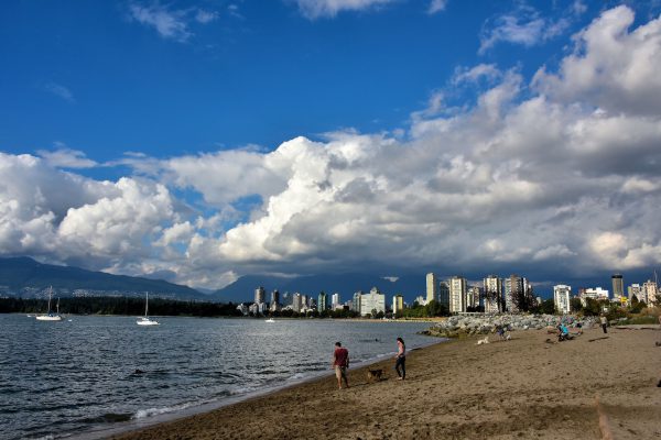
Vancouver, Canada, has done the perfect job of blending tall, beautiful skyscrapers with surrounding waterways and plenty of green spaces like Stanley Park on the left. It creates a wonderful environment for working, living or a day at Kitsilano Beach like this couple is enjoying with their dog near Hadden Park.
1305 Arbutus St, Vancouver, BC V6J 5N2, Canada Enlarge/Slideshow See On Map Directions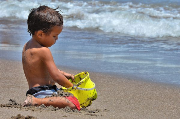
Give a young boy a pail at the beach and he will be mesmerized for hours. There are so many important things to do. Put the sand into the bucket and then dump the sand out. Build a castle and then knock it down. Whine when you are interrupted for more sunscreen and then go back to work.
545 Av. Comandante San Martín, El Laucho Beach, Arica, Región de Arica y Parinacota, Chile Enlarge/Slideshow See On Map Directions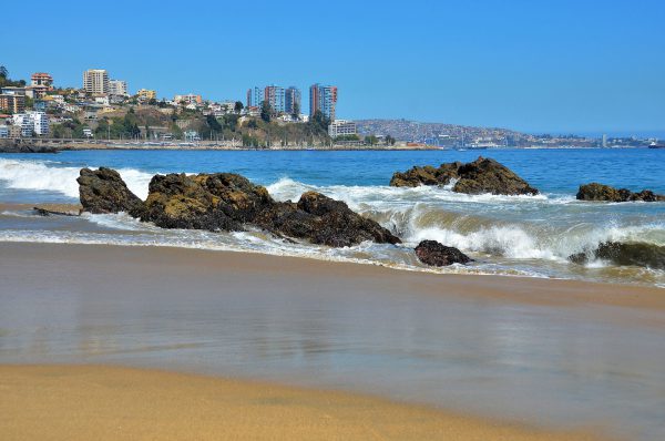
You would expect the Pacific to be warm in Central Chile during the peak tourist season of December through March. But the coastline is affected by the Humboldt Current. This ocean flow brings cold water from the southern tip of the country so swimming can be nippy. Yet it also delivers excellent waves that delight surfers and skimboarders.
Playa Caleta Abarca Avenida España S/N, Viña del Mar, Región de Valparaíso, Chile Enlarge/Slideshow See On Map Directions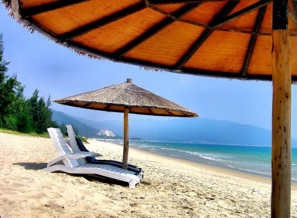
Hainan is an island in the South China Sea whose capital is Sanya. Until recently, it was unspoiled. Away from the few cities, you will see tropical forests and farmers in conical straw hats guiding oxen through rice paddies. The coastline offers pristine beaches and bays like Haitang where thatched umbrellas and loungers welcome you to a perfect afternoon. Fortunately or unfortunately, Sanya has been discovered by major hotel chains.
Ye Zhou Lu Haitang Qu, Sanya Shi, Hainan Sheng, China Enlarge/Slideshow See On Map Directions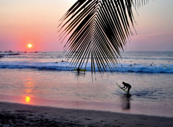
Located in the northern Pacific coast of Costa Rica, Tamarindo is a small town that is a haven for surfers. It also attracts tourists who love to zipline, sun, fish, snorkel and body surf. Before dusk, you should order your favorite libation on the beach and then enjoy the gorgeous sunsets. Even the monkeys from the local forest converge on trees to watch the spectacular colors.
Calle Cruz, Provincia de Guanacaste, Tamarindo, Costa Rica Enlarge/Slideshow See On Map Directions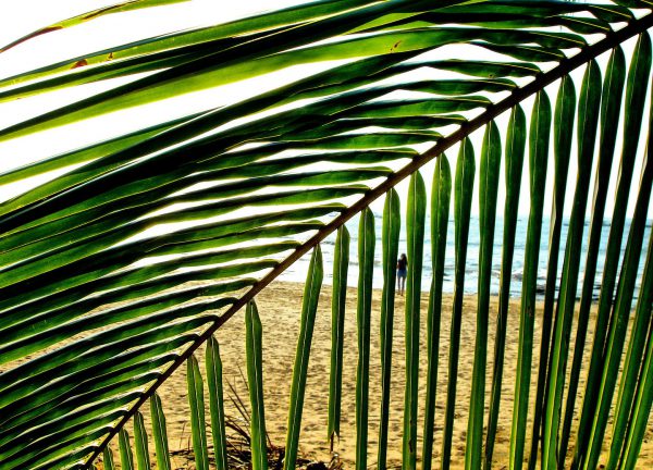
Tamarindo, Costa Rica, is perfect for suffers: small and laidback with white, pristine beaches and perfect waves. It was made famous in the 1994 surfer movie “Endless Summer II” yet remains unspoiled. For example, you are likely to see cows rooming the one dusty street in this town of 500. So, if you’re looking for isolation and warmth, then go to Playa Tamarindo, side step the Leatherback Turtles and put your toes into the Pacific Ocean like this woman seen through the palm leaves.
Calle Cruz, Provincia de Guanacaste, Tamarindo, Costa Rica Enlarge/Slideshow See On Map Directions
Most tourists visit the island of Korčula during the summer months when its Adriatic-Mediterranean climate has an average daily high of 72° to 76° Fahrenheit and about a dozen hours of sunlight. So when you set off for a day of sightseeing in the Old Town of Korčula, make sure to bring your bathing suit and a towel. You can enjoy a quick tip in the peaceful waters of Luka Korčulanska Bay or what the locals call Luka Us. Also take time to admire the seasonal mansions that line the coast. Most of them were built during the early 20th century.
Put Svetog Nikole 28, 20260, Korčula, Croatia Enlarge/Slideshow See On Map Directions
During the summer months, Split’s average temperature is well into the 80°s Fahrenheit. That is when the locals cool off at nearby Bacvice Beach. This crescent-shaped cove is nearly 2,000 feet long and 590 of them are covered with sand. The shallow water is ideal for families with kids.
Šetalište Petra Preradovića 5, 21000, Split, Croatia Enlarge/Slideshow See On Map Directions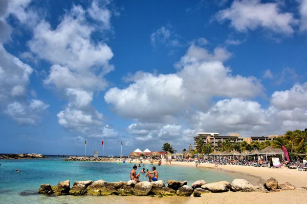
Most of Curaçao’s best beaches are protected from the Caribbean waves by seawalls consisting of giant boulders. These barriers create calm, crescent-shaped lagoons. They are ideal for swimming like this one at Cabana Beach. The breakwaters also make the perfect spot to sit with your partner while soaking up the sun.
The Beach House z/n Bapor Kibrá, Willemstad, Curaçao Enlarge/Slideshow See On Map Directions
There are two stretches of white sand and mild surf around Bayahibe. About three miles south of town is Dominicus Beach. The best spot for sun worshipers is Bayahíbe Beach. Although both are populated by resorts, a delightful section of each is reserved for the public. This is the shoreline of Hilton La Romana Resort adjoining Playa Publica Bayahibe. All you need for a perfect day is a swimsuit, suntan lotion and a smile.
Playa Publica Bayahibe, Carr. a Bayahibe 1, 23000, Dominican Republic Enlarge/Slideshow See On Map Directions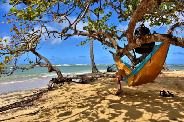
The energy level picks up at Playa Punta Popy near Las Terrenas. This is the center for water activities. Windsurfers and kitesurfers compete for the waves, along with occasional paddle boarders. Sailboats float along the horizon. Beneath the water are plenty of scuba divers and snorkelers. Then there are contrarians who come to relax. His formula was: buy a hammock, find the perfect tree, hang backpack, remove sandals and curl up in tropical solitude.
Playa Punta Popy, Las Terrenas 32000, Dominican Republic Enlarge/Slideshow See On Map Directions
Okay, it is time to convert your winter daydreams into tropical reality. Punta Cana has eight beaches. You have just arrived at Playa Bávaro. This is the best beach in La Altagracia Province and among the finest on the island. Endless white sand. Gentle waves rolling over a coral reef. Transparent balmy water. Coconut palms waving in the breeze. Sure, there is occasional seaweed. But the hotels are constantly grooming Bávaro Beach. No wonder this area is highly developed with resorts, shops, restaurants, water activities plus two water parks. They will not deter your joy during your long stroll. How long? From end-to-end, Bávaro Beach stretches for over six miles. For a public access, follow Calle Chicago ending at Meliá Caribe Tropical.
Playa Bávaro, Calle Chicago, Punta Cana 23301, Dominican Republic Enlarge/Slideshow See On Map Directions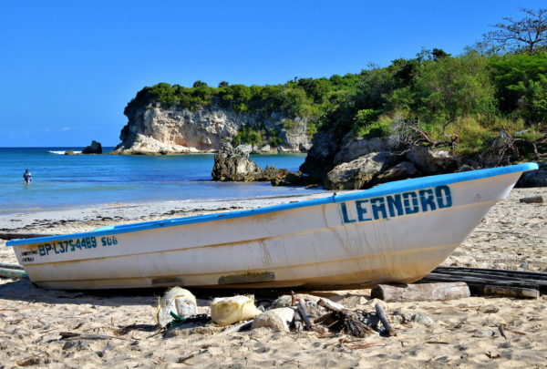
The secret is out about the pristine coastline at Macao Beach. So in high season – especially on weekends – it can get crowded. Yet most swimsuit-clad vacationers concentrate near the entrance. The further you walk in either direction, the more you can be alone in paradise. Especially picturesque is this headland at the east end of the crescent-shaped cove. Some locals call this Playa Escondida meaning “hidden beach.” Shhh … don’t tell anybody about your tropical haven.
Playa Escondida, Playa Macao, Punta Cana 23000, Dominican Republic Enlarge/Slideshow See On Map Directions
Tucked between a small town and the rolling surf is Playa Los Cacaos. Locals and vacationers blend together while swimming and sunning in the shadows of royal palms. As idyllic as this looks – and it is – beach connoisseurs should consider taking a short boat ride from here to Cayo Laveantado. The two-square-mile wedge of Caribbean utopia is nicknamed Bacardi Island. Many rate its stretch of white sand among the best in the Dominican Republic. The only word of caution is Cayo Laveantado gets very crowded when cruise ships are in port.
Playa Los Cacao, Samana 32000, Dominican Republic Enlarge/Slideshow See On Map Directions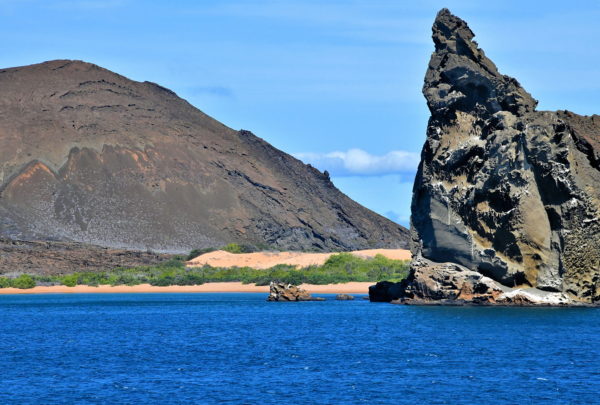
Bartolomé Island’s famous landmark is Pinnacle Rock. This volcanic cone is also called The Tower. The jagged façade is stunning. These are layers of basalt spewed from the sea by an underwater volcano. Equally inviting is the coralline beach (La Playa). The landing here is a wet one. Snorkeling along this north shore is ideal for swimming with stingrays, sharks, sea lions, sea turtles and adorable penguins. However, the waters on the south side are too rough and dangerous.
Bartolomé Island, Ecuador Enlarge/Slideshow See On Map Directions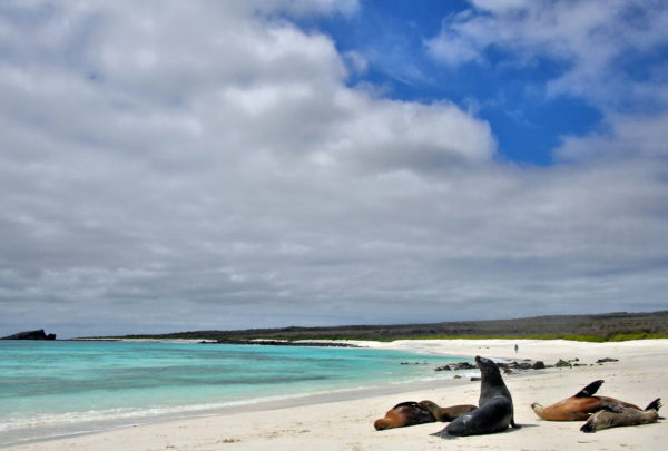
The 1.25 mile beach at Gardner Bay rivals any you will find in the tropics. The white coralline sand is hard along the shoreline, making it perfect for a stroll. Another option is to sit, relax and bask in the sun while watching the rolling waves. Or follow the lead of the sea lions and take a nap. The best spots for savoring this picturesque bay are on the sand dunes along the thick saltbrush. There are no trails at Gardner Bay. So, leave your hiking shoes behind. Appropriate footwear here are water shoes, flip flops or, best yet, no footwear at all.
Bahía Gardner, Española Island, Ecuador Enlarge/Slideshow See On Map Directions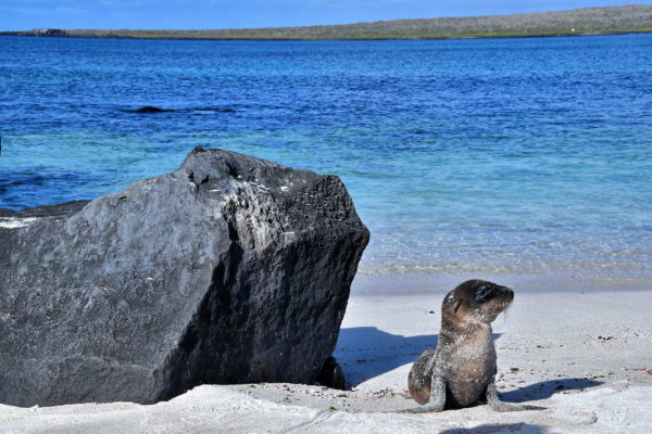
Española Island defines the southeast corner of the Galápagos. Sometimes referred to as Hood Island, this remote location is arid, barren and flat. These harsh conditions make Española Island uninhabitable for humans. Yet, this 23 square mile rock is a haven for wildlife. Your first stop is Punta Suárez, a promontory on the east coast of the island. Your small watercraft will make a dry landing along a concrete pier. There to greet you will be a colony of sea lions. Especially camera worthy are several pups basking on the beach in the Ecuadorian sunshine.
Punta Suárez, Española Island, Ecuador Enlarge/Slideshow See On Map Directions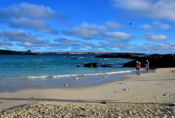
The marked trail at Darwin Bay Beach is less than a half mile. Surely such a short path can’t maintain your interest during a two-hour visit. Wrong! The time disappears in a flash. You are in constant awe of the beautiful scenery and incredible wildlife. Then, as the shadows grow long and the inflatable boats return to shore, you will linger along the sand and be reluctant to end the experience. Savor the moment before saying goodbye to Genovesa Island.
Great Darwin Bay, Genovesa Island, Galápagos, Ecuador Enlarge/Slideshow See On Map Directions
Toward the end of your exploration of North Seymour Island, the barren, harsh landscape opens up to a long stretch of pristine sand. The shoreline is defined by piles of lava rock. Their smooth surfaces were polished while tumbling along the floor of the Pacific Ocean. In the distance are the Daphne Islands. Daphine Major is on the left and Daphne Minor is on the right. Both of these tuff cones were formed by volcanic activity. They are uninhabited and treeless yet do support colonies of birds.
North Seymour Island, Ecuador Enlarge/Slideshow See On Map Directions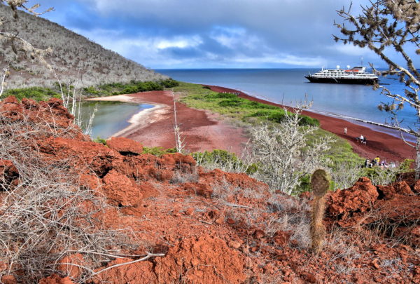
You will be awed by the landscape after your wet landing at the northeast side of Rábida Island. You may be so engrossed by the forest of white trees encircling the reds, oranges, pinks and greens that you might not notice the sea lions sleeping on the maroon beach. Some people call this “moon on earth.” Another nickname is the Red Island. This travel guide shows some highlights of your 60 to 90 minute hike. The .7 mile trail is easy. The experience is unforgettable.
Rábida Island, Ecuador Enlarge/Slideshow See On Map Directions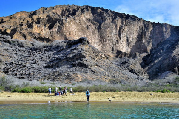
As you approach Punta Pitt, you will notice something unusual about the 295 foot beach. The sand has a green hue. This color stems from translucent olivine crystals reflecting in the light. Although this mineral is very common inside of the earth, it tends to weather quickly when exposed to air, wind and waves so rarely retains its olive coloring. They occurred at Punta Pitt because the mineral content of the volcanic ash was high in magnesium and low in silica.
Punta Pitt, San Cristóbal Island, Ecuador Enlarge/Slideshow See On Map Directions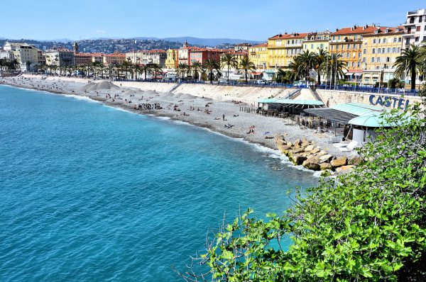
This gorgeous view of the Mediterranean coast in Nice epitomizes the French Riviera’s beauty. It is called Baie des Anges or Bay of Angels. I assumed it derived its name from the angelic atmosphere offered by the warm sunshine, the beaches and the promenades. However, the origin comes from the squatina angelus, a shark that has two fins shaped like angel wings. But don’t worry … it has not been seen in these waters since the 19th century.
11 Quai Rauba Capeu, 06300 Nice, France Enlarge/Slideshow See On Map Directions
This town of 8,500 people in northern Germany is called Warnemünde Seaside Resort. That is more than a moniker written for marketing brochures. The Badestrand or bathing beach has a width of nearly 500 feet that stretches for almost two miles along the Baltic coastline. So, take off your shoes. Then, let your toes enjoy the white sand and warm surf while you stroll along the beach with your partner. What a perfect way to spend a perfect afternoon.
Seepromenade 3, 18119 Rostock, Germany Enlarge/Slideshow See On Map Directions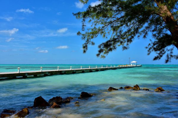
A day at the beach can be so exhausting. Here is a formula for reliving your tensions at Rum Point. 1. Stroll the pier. 2. Get a beach massage. 3. Sip a Mudslide or two. This cold concoction of vodka, Kahlua and Bailey’s Irish Cream was invented here. 4. Finally, crawl into an available hammock and let the waves be your lullaby for a great nap. Repeat as necessary.
Sand Point Rd & Rum Point Dr, Rum Point, Cayman Islands Enlarge/Slideshow See On Map Directions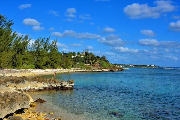
Cruise ships going to Grand Cayman typically arrive at George Town. When the Caribbean waves are rough, many ships are turned away while a lucky few anchor off the southern shore. This alternative port in Savannah is stark, congested and not convenient to tourist sites. Yet there is one refreshing advantage: after touring the largest of the Cayman Islands all day in the bright sunshine, a quick dip in the water near Spotts Public Beach is heavenly.
Spotts Beach Shamrock Rd, Savannah, Cayman Islands Enlarge/Slideshow See On Map Directions