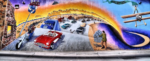
This colorful mural called “Mother Road” was designed by Joe Stephenson and sponsored by Working Classroom. The vivid art is a tribute to Route 66 connecting Chicago with Los Angeles. The iconic road cut through Albuquerque on Fourth Street starting in the mid-20s and switched to Central Avenue in 1937. Among the vehicles driving down “The Main Street of America” is a 1960 Roman Red Corvette convertible. The classic originally sold for less than $4,000. Today, the collectors’ item fetches up to $75,000. Apparently, nostalgia does not come cheap.
212 2nd St SW, Albuquerque, NM 87102 Enlarge/Slideshow See On Map Directions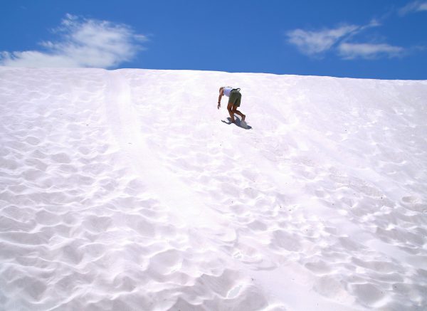
The dunes in southern New Mexico cover over 140,000 acres. They consist of gypsum crystals called gelenite. Unlike sand, they are pure white, continually shift and blow and do not convert sunlight into heat. So kids slide down the dunes on saucers in shorts and bare feet while nearby snow plows keep the roads open. An eight mile road into this geologic anomaly is provided by the White Sands National Monument. Nearby is a missile range where the first atom bomb was detonated.
Yucca Picnic Area Loop Dr, Tularosa, NM 88352 Enlarge/Slideshow See On Map Directions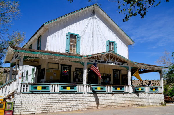
Madrid, New Mexico, has not grown much since starting as a coal mining town in the 1850s. Many of its 150 citizens cater to tourists driving by. Route 14 is lined with artisans in historic buildings. An example is the Old Boarding House Mercantile. Among the novelties for sale are memorabilia from a biker movie filmed there in 2007. “Wild Hogs” stared John Travolta and Tim Allen.
2887 NM-14, Madrid, NM 87010 Enlarge/Slideshow See On Map Directions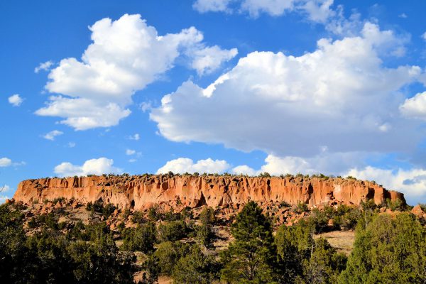
New Mexico’s Bandelier National Monument is wedged in a valley surrounded by mounts ranging in height from 5,000 to 10,000 feet. The sun and clouds create dancing shadows as you look down from the peak. Once you descend, you will find Ancestral Pueblo dwellings and petroglyphs carved into cliffs dating from 1150 – 1600. The area also has several mesas. These tabletop mountains glow during the sunset.
15 Entrance Rd, Los Alamos, NM 87544 Enlarge/Slideshow See On Map Directions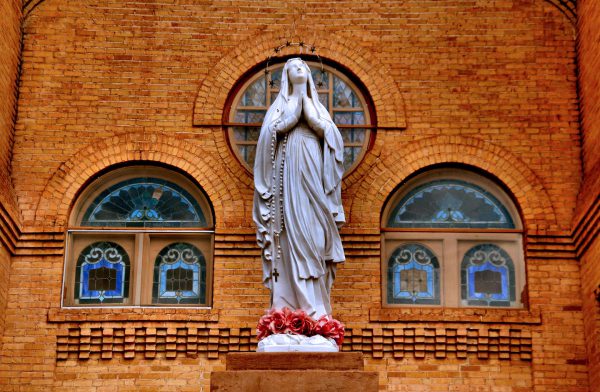
Mesilla, New Mexico, became a town when the area was considered “No Man’s Land” during a Mexico and U.S. border dispute in 1851. The same year, the San Albino mission was formed. Thirty years later, Billy the Kid was tried, found guilty and sentenced to hang for murdering Sheriff Brady. These historic events are retold in shops surrounding Mesilla Plaza and anchored by the Basilica of San Albino. Dedicated in 1908, the church was declared a minor basilica by the Holy See 100 years later. This statue of the Virgin Mary stands in front of its brick façade and leaded, stained-glass windows.
2070 Calle De Santiago, Mesilla, NM 88046 Enlarge/Slideshow See On Map Directions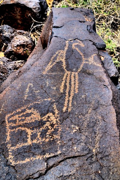
Volcanoes once scarred the 7,200 acres called Petroglyph National Monument in New Mexico just west of Albuquerque. Many of the ancient magma rocks display 24,000 carvings. The primitive designs were created by the Ancestral Pueblo people from 400-700 years ago. The petroglyphs include images of birds, animals, faces, plants and symbols. You can study this ancient art along developed trails. You can also climb around two canyons and discover more such as this macaw in Boca Negra Canyon.
Boca Negra Canyon, Atrisco Dr NW, Albuquerque, NM 87120 Enlarge/Slideshow See On Map Directions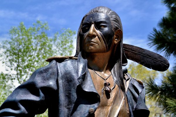
Around 900 AD, the Pueblo Indians settled on the land now occupied by downtown Santa Fe, New Mexico. The Native Americans continued living there through the Pueblo Revolt against the Spanish in 1680. The uprising was led by Popé, also known as Po’pay. This statue looks similar to the fierce leader of 2,500 Pueblos. The sculpture is located in the Canyon Road Art District. This quaint neighborhood features over 100 galleries of western and Native American contemporary art, sculptures and jewelry.
McLarry Modern, 225 Canyon Rd #8, Santa Fe, NM 87501 Enlarge/Slideshow See On Map Directions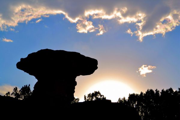
Erosion carved this sandstone bluff called Camel Rock into the shape of a sitting camel in Tesuque, New Mexico. The stone camelid looks right at home in the arid surroundings while basking in the sunset. Across U.S. 84-285 is another Camel Rock. That entertainment establishment is a Pueblo-managed casino with a great buffet. In this reservation of 500 Native Americans, you will also find artisans offering paintings and pottery.
285 Frontage, Camel Rock, Santa Fe, NM 87506 Enlarge/Slideshow See On Map Directions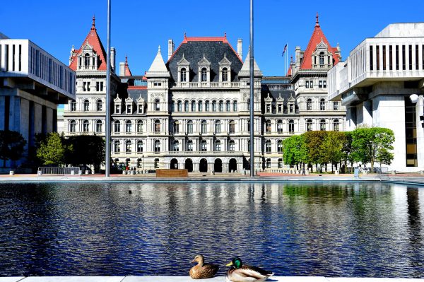
These two mallards are viewing the southwest side of New York’s State Capitol beside a pond on Empire State Plaza. This five-story, granite and marble building with red tower accents would have risen beyond its 220 feet if the planned dome had been built in 1899. It took 32 years to complete at today’s cost of half a billion dollars. New York became the 11th state on July 26, 1788.
State St. & Washington Ave, Albany, NY 12224 Enlarge/Slideshow See On Map Directions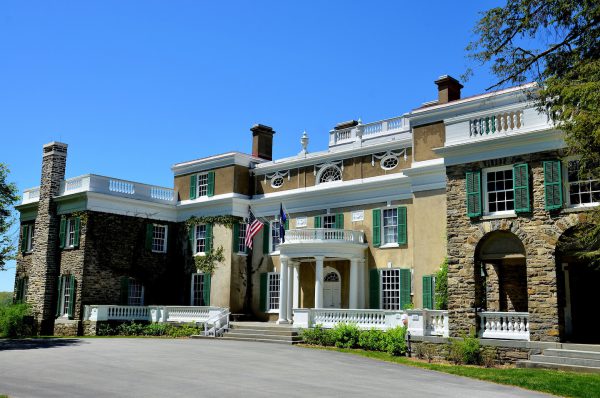
On the grounds of the Franklin D. Roosevelt Library and Museum in Hyde Park, New York, is the 32nd president’s home called Springwood. FDR was born on the second floor, lived here most of his life and is buried in the rose garden. Interred beside him are his wife and family dogs. The mansion remains furnished as it was while the Summer White House. Roosevelt’s wife, Eleanor, lived two miles away in a home called Val-Kill. Both of these fascinating homes are available for tour.
4097 Albany Post Rd, Hyde Park, NY 12538 Enlarge/Slideshow See On Map Directions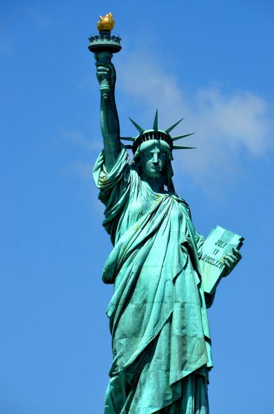
In the middle of New York Harbor is an iconic image of the 238 BC Roman goddess named Libertas. Everyone calls her the Statue of Liberty. The gift from France in 1886 was sculpted by Frédéric Bartholdi. Gustave Eiffel created the framework. The crowned and robed figure stands 351 feet on Liberty Island. She welcomed more than 12 million immigrants as they were processed at Ellis Island from 1892 to 1954. They were the ancestors of one-third of today’s U.S. population. She holds a tablet with the date July 4, 1776. Approximately four million people visit her each year.
Liberty Island, New York, NY 10004 Enlarge/Slideshow See On Map Directions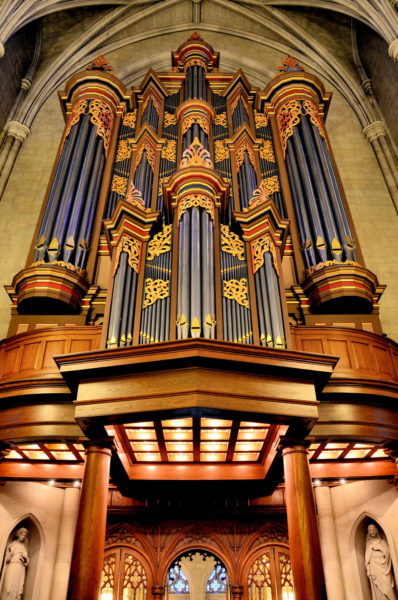
After passing through the narthex and entering the nave of the Duke University Chapel in Durham, North Carolina, look up at the oak gallery and marvel at the 1976 Flentrop Pipe organ. It is beautiful! Also called the Benjamin Duke Memorial Organ, the musical instrument is 40 feet tall, contains over 5,000 pipes, is made from African mahogany and is gilded with gold. A brief concert is played on most weekdays at 12:30.
401 Chapel Dr, Durham, NC 27708 Enlarge/Slideshow See On Map Directions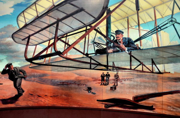
Two brothers who did not finish high school, ran a marginally successful newspaper and then a bicycle shop shared a dream: to master motor-driven flight. From 1899 until 1903, the Wright Brothers generated extensive data from a home-built wind tunnel. The duo also tinkered with bike parts and motors to create and test various gliders. This painting at the Wright Brothers National Memorial depicts their first manned flight of 120 feet at Kill Devil Hill on December 17, 1903.
Visitor's Center, Wright Memorial, Kill Devil Hills, NC 27948 Enlarge/Slideshow See On Map Directions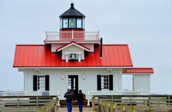
In Shallowbag Bay in Manteo, North Carolina, is a 2004 reconstructed lighthouse called Roanoke Marshes Light. Similar to a dozen screwpile lighthouses from the late 1800s, this one has a square, cottage-style construction. This area is also known for the “Lost Colony.” They were a group of 100+ English colonists who landed here in 1587 but disappeared by 1590.
Roanoke Marshes Lighthouse, Queen Elizabeth Ave, Manteo, NC 27954
Raleigh, North Carolina is named after Sir Walter Raleigh. He was an English aristocrat, spy, explorer and advocate of tobacco smoking who was beheaded in 1618. Starting at the state capitol, Fayetteville Street runs through the heart of downtown. On the right is the NC State Museum of Natural Sciences. Their fascinating exhibits include dioramas of wildlife and pre-historic life such as dinosaurs.
11 W Jones St, Raleigh, NC 27601 Enlarge/Slideshow See On Map Directions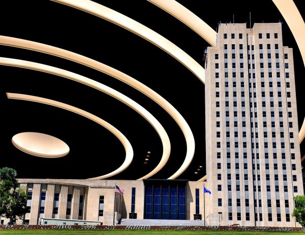
Two-photo composite of Bismarck, North Dakota are: The spiral, Art Deco ceiling of the North Dakota House of Representatives chamber and; The 19-story North Dakota State Capitol built in 1955 known as the Skyscraper of the Prairie.
600 E Boulevard Ave, Bismarck, ND 58505 Enlarge/Slideshow See On Map Directions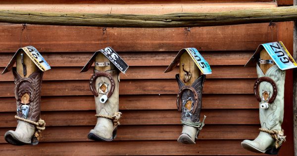
In western North Dakota, near the Montana border, is Medora. This small town is the gateway to the Badlands and Theodore Roosevelt National Park. Within a few blocks is a quaint, western theme among historic buildings. These cowboy boot hooks with vintage licenses plates make a perfect memento of your trip to Medora.
250 Main St, Medora, ND 58645 Enlarge/Slideshow See On Map Directions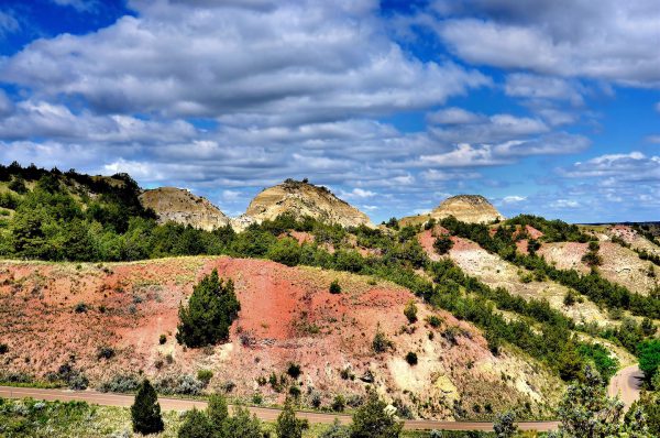
In 1884, Theodore Roosevelt’s wife and mother died on the same day, causing him to abandon his early political career. He sought solitude in the Badlands in North Dakota. Roosevelt became a rancher, hunter and deputy sheriff. His Maltese Cross Cabin and Elkhorn Ranch can be visited at Theodore Roosevelt National Park. You are also likely to see wild horses, buffalo, deer, sheep and elk roaming in the vibrant, rolling terrain and patchy grasslands of this 70,446 acre park.
201 E River Rd, Medora, ND 58645 Enlarge/Slideshow See On Map Directions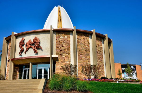
71,000 people attended Super Bowl XLVII in 2013. That number is equivalent to the population of Canton. This Ohio city is where the National Football League was founded in 1920 and the Pro Football Hall of Fame was built in 1963. Fifty years later, 280 inductees are honored inside the 82,300 square-foot museum. Only four to seven new members are added each year after an extensive nomination, selection and voting process.
2121 George Halas Dr NW, Canton, OH 44708 Enlarge/Slideshow See On Map Directions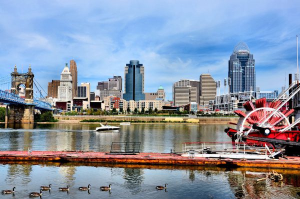
The skyline on the north bank of the Ohio River only hints at the beauty of this city. Once you cross the John Roebling Suspension Bridge, you are greeted by the vibrance of Cincinnati. The population of 300,000 love their sports (seven major facilities), riverfront, entertainment venues, historic buildings, arts and gorgeous outdoor wall murals. Cincinnati is also home to fifteen Fortune 1000 companies including The Kroger Company and Proctor & Gamble. In the foreground is an Ohio River paddle steamer boat and a flock of Canadian geese.
Riverside Dr & Riverside Pl, Covington, KY 41011 Enlarge/Slideshow See On Map Directions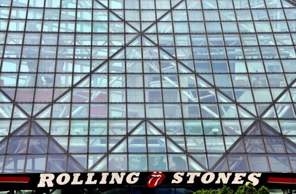
Behind this glass pyramid façade on Lake Erie are the stories and artifacts of rock music and a tribute to the legends who created the genre. It is all in the seven-level, 55,000 square foot Rock and Roll Hall of Fame. Exhibits include costumes and instruments from famous musicians plus back stories on the not-so-famous who made significant contributions in composing, journalism, and production. Also highlighted are the early jazz, folk, blues and country artists who inspired the emergence of rock. Nearby is another building dedicated to the museum’s library and archives.
1100 E 9th St, Cleveland, OH 44114 Enlarge/Slideshow See On Map Directions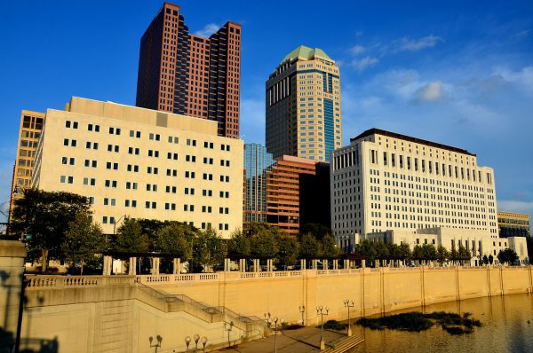
This is a profile of the downtown Columbus skyline along the Scioto River at sunset. The country’s fifteenth largest city took its name from Christopher Columbus. It is located in the center of Ohio and is the state capital. Columbus has received numerous “top ten” recognitions from several magazines. Among the attributes are their business environment, technology, future outlook, zoo, working moms, strong economy and being mentioned as one of the best big cities. All of these accolades are well deserved. Columbus warrants a visit.
W Broad St. & S Civic Center Dr, Columbus, OH 43215 Enlarge/Slideshow See On Map Directions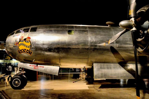
Look closely at the five “fat man” silhouettes under the pilot’s window of this B-29 bomber called Bockscar. The red symbol represents the mission on August 9, 1945. On that historical day, Major Charles Sweeney and his crew dropped the second and more powerful nuclear bomb on Nagasaki. The Japanese surrendered four days later and WWII was over. The plane, along with over 350 other aircraft, is on display at the National Museum of the United States Air Force near Dayton, Ohio.
1100 Spaatz St, Dayton, OH 45431 Enlarge/Slideshow See On Map Directions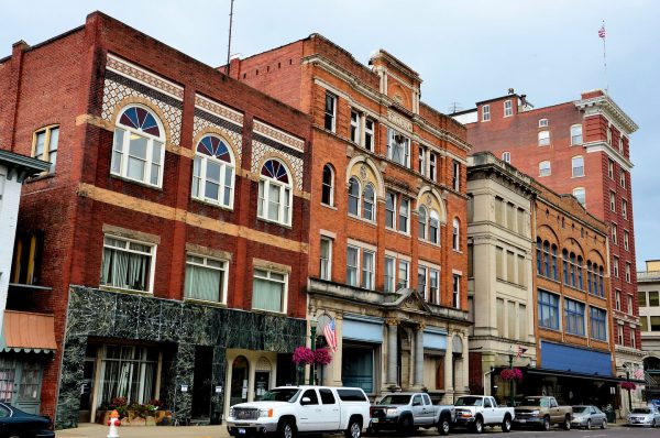
Marietta is a town of about 14,000 people along the western boarder of Ohio just across the Ohio River from West Virginia. Third Street is the heart of their downtown. It is typical of other small U.S. towns that were founded in the 19th century, grew and prospered for decades, slowly lost their significance and then began to decline in income, economic stability and population. Yet Third Street has kept its pride and remains a pleasant place to live as do so many other small towns in the country’s heartland.
200 Union St # 4, Marietta, OH 45750 Enlarge/Slideshow See On Map Directions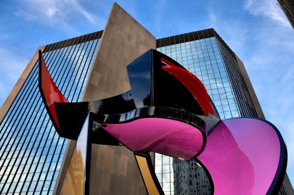
In Levis Square near the Toledo Edison building (in the background) is this 15 foot, 1984 aluminum sculpture called “Kabuki Dancer” by Jerry Peart from Ashland, Virginia. Kabuki is a Japanese word dating back to 1603. It represents a type of dance, drama or theater that is characterized by elaborate, colorful costumes and make-up. The sculpture was commissioned by the One Percent for the Arts program and funded by the Toledo Area Regional Transit Authority
300 Madison Ave, Toledo, OH 43604 Enlarge/Slideshow See On Map Directions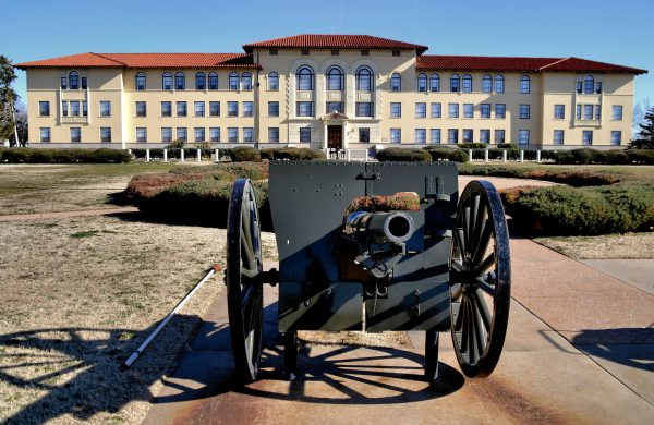
Fort Sill in Lawton, Oklahoma, was built in 1869 during the Indian wars. The property is still an active Army post. The artillery museum displays guns and uniforms dating back to 1775. The exhibits include this 76 mm Regimental Gun used in 1927. Also on the grounds are the burial sites of Indian prisoners. The most famous one is the grave of Geronimo, a leader of the Chiricahua Apache tribe. He lived from 1829 until 1909.
455 McNair Rd #118, Fort Sill, OK 73503 Enlarge/Slideshow See On Map Directions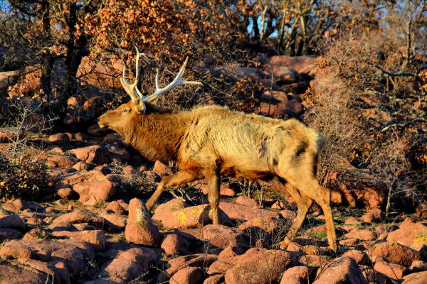
This bull Rocky Mountain elk wandering free in the Wichita Mountains Wildlife Refuge is one of six subspecies of elk in North America. The bulls weigh about 700 pounds. Their antlers, which are shed each winter, can weigh as much as 40 pounds. There are also herds of American bison, Texas longhorns and white-tailed deer on this 59,000 acre reserve near Lawton, Oklahoma. You will often see them grazing along the road.
32 Refuge Headquarters Road, Indiahoma, OK 73552 Enlarge/Slideshow See On Map Directions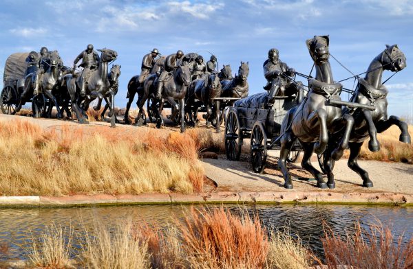
When a cannon was fired at noon on April 22, 1889, 50,000 people scrambled to homestead their piece of two million acres of available land during the Oklahoma Land Rush. That historic event is commemorated in the Bricktown District of Oklahoma City with spectacular bronze statues by Paul Moore. This photo shows the first pieces created in 2003. By 2015, the Land Run Monument included 45, 1 ½ size sculptures of horses and covered wagons all fighting to claim the choicest land parcels previously owned by Native Americans.
200 Centennial Ave, Oklahoma City, OK 73102 Enlarge/Slideshow See On Map Directions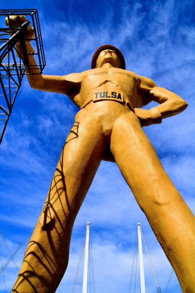
The world’s tallest, free-standing statue is the 76 foot “Golden Driller” in Tulsa. This tribute to the once booming oil industry in Oklahoma was first created in 1953 for a petroleum exposition. This 1966 version of the 22 ton, yellow giant stands next to the Tulsa County Fairgrounds. His right hand rests on an actual oil derrick. His shoe size is 393DDD. The statue was commissioned by the Mid-Continent Supply Company of Fort Worth.
Tulsa Expo Center, 4145 E 21st St, Tulsa, OK 74114 Enlarge/Slideshow See On Map Directions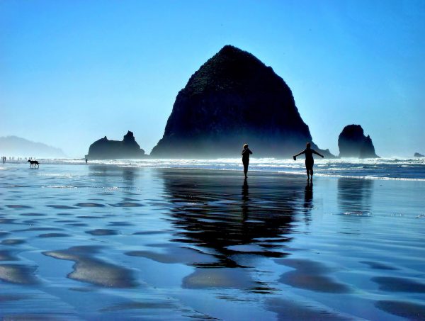
On Oregon’s Pacific coast is the fascinating Haystack Rock. The giant monolith rises 235 feet from the sands of Cannon Beach. It is accessible from shore during low tide. At high tide, however, be careful: many people have been stranded by fast rising water and had to be rescued. Next to it are two smaller yet impressive rock towers called the Needles. This sandy beach and shallow, warm water are perfect for a barefoot stroll with your best friend.
1766 S Hemlock St, Tolovana Park, OR 97145 Enlarge/Slideshow See On Map Directions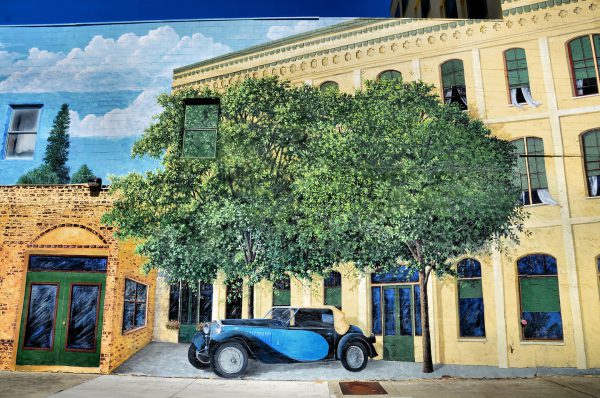
The Hotel Josephine in Grants Pass, Oregon, was built in 1893. Each room of the luxury accommodations featured electricity, gas for cooking and a wood burning stove for heat. The original building was destroyed by fire in 1975. This mural painted on the 1925 expansion shows the hotel in its early 20th century glory. This is the left detail of the wonderful mural painted by John Michener.
310 NW 6th St, Grants Pass, OR 97526 Enlarge/Slideshow See On Map Directions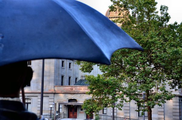
The locals in Portland, Oregon, call the Pioneer Courthouse Square their living room. It is adorned by a life-size statue of a businessman wearing a three-piece suit, carrying a blue umbrella and hailing a taxi. The sculpture by Seward Johnson is named “Allow Me.” The locals refer to it as, “Umbrella Man.” The adjoining federal building that lends its name to the plaza is the oldest in the Pacific Northwest. The Pioneer Courthouse was built in 1875, over one hundred years before the square opened.
701 SW 6th Ave, Portland, OR 97205 Enlarge/Slideshow See On Map Directions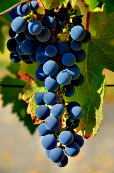
Mention west coast vineyards and the immediate association is California. The Golden State produces 90% of American wine. However, its neighbor to the north has over 300 vineyards. Most of Oregon’s vintages are delicious and reasonably priced. The vineyards are famous for their Pinot Noir. Clusters of black grapes like these are responsible for the delectable wine.
Delfino Vineyards, 3829 Colonial Rd, Roseburg, OR 97471 Enlarge/Slideshow See On Map Directions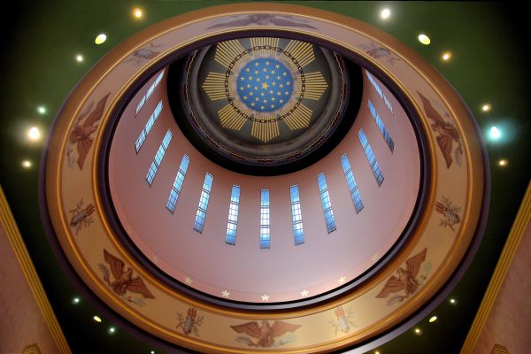
In the floor of Oregon’s State Capitol is a bronze replica of the state seal. Between it and the dome’s 106 foot ceiling are four large murals portraying key historic events such as the Lewis and Clark Expedition. The interior also features a ring of eagles, slender rectangular windows and eight medallions representing the state seal. The 33 stars signify Oregon’s admission as the 33rd state on February 14, 1859.
900 Court St NE, Salem, OR 97301 Enlarge/Slideshow See On Map Directions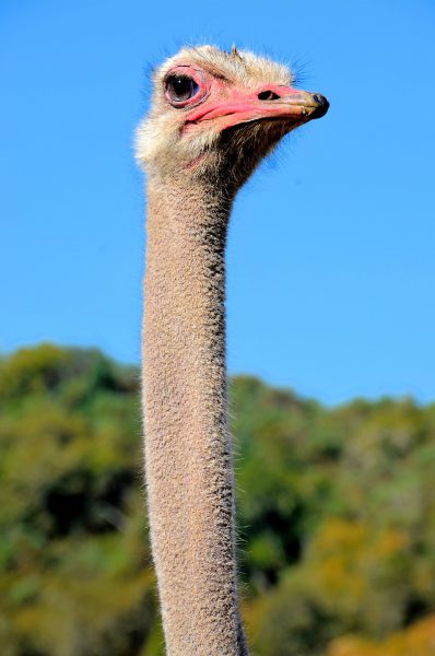
The tallest ostrich species is this red-necked or North African ostrich. The bird stands over nine feet tall thanks to his enormous pink neck and long legs. Once widespread in Northern Africa plus parts of Egypt and Morocco, it is now considered critically endangered. This 300 pound, flightless bird can be seen at the 600 acre Wildlife Safari in Winston, Oregon.
Enlarge/Slideshow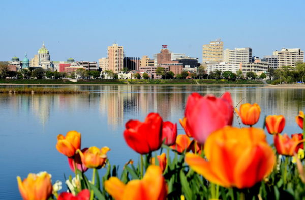
At 464 miles, the Susquehanna River is the longest on the east coast and is nearly a mile wide when it passes through Harrisburg. From across the river, this capital city has a gorgeous skyline. Native Americans called this area Paxtang when they enjoyed this shoreline view thousands of years ago.
301 N Front St, Wormleysburg, PA 17043 Enlarge/Slideshow See On Map Directions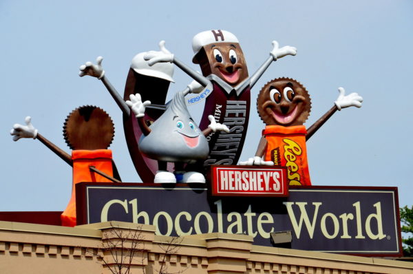
When the Swiss invented milk chocolate in 1875, the expensive luxury had a short shelf life. That changed in 1899 when Milton Hersey developed a process to mass produce the delicacy. He then built a plant and town now called Hersey, Pennsylvania. This facility produces the branded syrup, Kiss, Mr. Goodbar, Krackel and later acquired Reese’s and Twizzlers. In 1973, Hersey’s Chocolate World opened as an amusement park. The attraction offers rides and a tour of the chocolate making process. This is a haven for kids in a candy store.
101 Chocolate World Way, Hershey, PA 17033 Enlarge/Slideshow See On Map Directions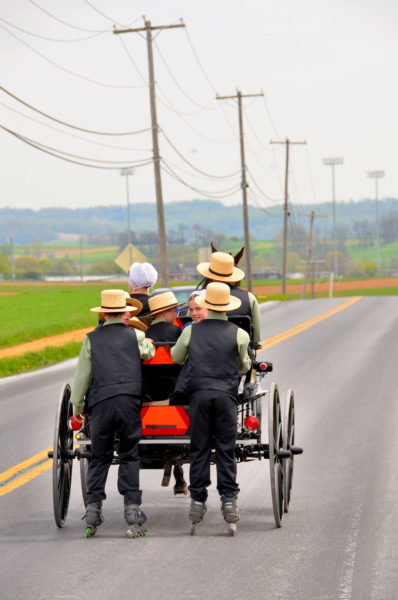
There are thousands of Pennsylvania Amish living the simple life in Lancaster County. Most are farmers or engaged in cottage industries such as crafts and furniture making. Driving maps of the area are available from local visitor centers. You will need to share the road with the horse and buggies. This family was too large for their vehicle. Therefore, the two eldest sons were dragged behind on their inline skates.
38 Witmer Rd, Lancaster, PA 17602 Enlarge/Slideshow See On Map Directions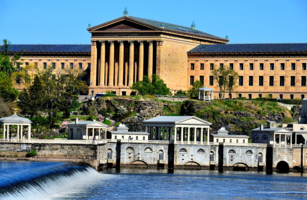
The Philadelphia Museum of Art opened in 1876 as part of the country’s centennial celebration. On the 72nd step are the cast footprints where Rocky Balboa raised his arms in triumph. On the backside of this Greek Revival building is the Schuylkill River. It flows 135 miles through Pennsylvania. In the foreground is the Fairmount Water Works. The public utility was built between 1812 and 1815. The original version supplied Philadelphia with fresh water in response to the yellow fever epidemic of the late 1700s.
640 Waterworks Dr, Philadelphia, PA 19130 Enlarge/Slideshow See On Map Directions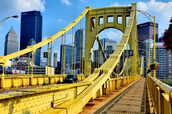
The Seventh Street Bridge was built in 1926. It is one of the “The Three Sisters” suspension bridges crossing the Allegheny River from the North Shore into downtown Pittsburgh. This yellow span is now called the Andy Warhol Bridge. This pays tribute to the city’s native son and pop art icon. Nearby is the Andy Warhol Museum. This bridge is one of over 440 connecting the city of Pittsburgh. This is why its nickname “The City of Bridges” is well deserved.
Andy Warhol Bridge, 7th St, Pittsburgh, PA 15212 Enlarge/Slideshow See On Map Directions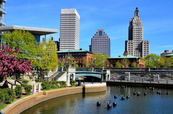
Roger Williams, the founder of Providence, Rhode Island in 1636, was exiled from Massachusetts for such radical beliefs as religious freedom and abolishing slavery. Today, along the Woonasquatucket River, is a cobblestone path located a level below the Downcity (downtown) streets. Called the River Walk in Waterplace Park, it provides pedestrian bridges that are reminiscent of Venice. Complete your feeling of visiting the Italian City of Bridges with a gondola ride.
200 Exchange St, Providence, RI 02903 Enlarge/Slideshow See On Map Directions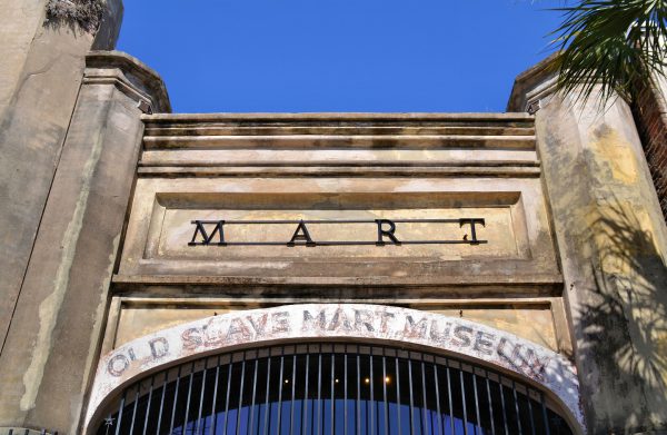
Slavery was once considered by plantation owners to be an essential element for success. Estimates suggest 10 to 20 million people were shipped and traded in America. When importing was banned, an inter-state business of public slave trading emerged. The practice was outlawed in 1856, giving rise to private auction galleries like the Old Slave Mart in Charleston, South Carolina. Once called Ryan’s Mart, it is now a museum and the only slave gallery left in the state.
6 Chalmers St, Charleston, SC 29401 Enlarge/Slideshow See On Map Directions
Storybook Land in Aberdeen, South Dakota recreates almost every nursery rhyme you remember as a kid. You will enjoy seeing 65 figures such as Jack n’ Jill, Humpty Dumpty and Goldilocks. Also in the 210 acres at Wylie Park is a step-by-step trail that tells the Wizard of Oz story. Best of all, admission is free. Come follow the yellow brick road.
Storybook Land, 2300 24th Ave NW, Aberdeen, SD 57401 Enlarge/Slideshow See On Map Directions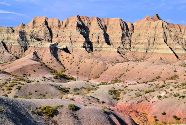
The South Dakota Badlands has a long history. About 75 million years ago, the land was underwater as part of the Western Interior Seaway. During the next 50 million years, the continent buckled several times. Each event led to an uplift until the sea was drained about 28 million years ago resulting in the Sharps Formation. Rivers then relentlessly carved the landscape. Volcanic activity produced layers of ash. During the last major uplift 4.5 million years ago, sediment from the nearby Black Hills flowed into the area. Each timeframe left behind layers of soil, rocks and fossils. This process is called deposition. About 500,000 years ago, the wind, rain, snow and sun began eroding this geological soup. Soft material disintegrated the fastest. Hard rock was more resistant. The results are what you admire today at the Badlands National Park. This spectacular scenery is work in progress. It erodes at the rate of one inch per year. Within another half million years, most of the rock formations will be gone.
Badlands Loop Road, SD-240, Wall, SD 57790 Enlarge/Slideshow See On Map Directions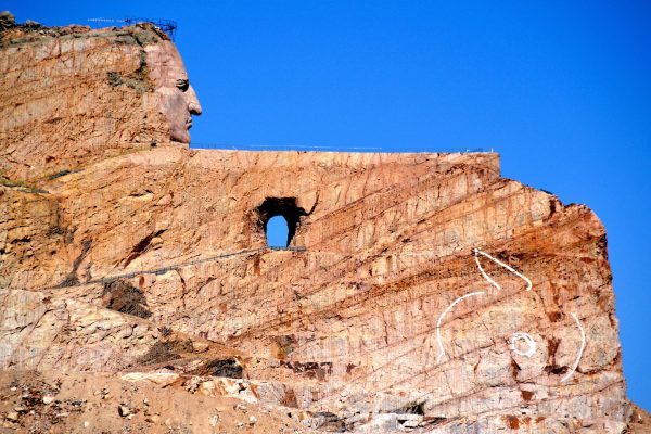
Some visions require persistence. The best example might be Crazy Horse Memorial in Custer County, South Dakota. The project was commissioned by Lakota Chief Henry Standing Bear. The sculptor, Korczak Ziolkowski, started carving the Indian warrior on a horse with an outstretched arm in 1948. Fifty years of hard work were needed to finish the face. After his death in 1982, his wife Ruth took control until she died in 2014. Now their children are heeding his advice of “Go slowly so you get it right.” There is no timeframe for completing this 560 foot monument in the Black Hills.
12151 Ave of the Chiefs, Crazy Horse, SD 57730 Enlarge/Slideshow See On Map Directions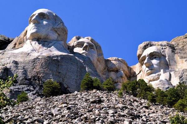
The cost of carving four, 60 foot president heads into Mount Rushmore from 1927 until 1941 was $10,000 shy of one million. This ambitious monument would have cost more if the original plans had been implemented to sculpture the bi-partisan foursome from the waist up. Susan B. Anthony almost joined this boys’ club. However, the congressional approval was overridden in 1937.
64 Presidential Trail, Keystone, SD 57751 Enlarge/Slideshow See On Map Directions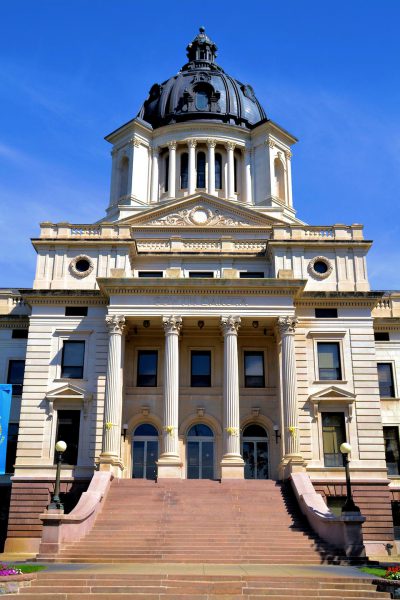
South Dakota was inhabited by the Sioux Indians plus French and European settlers before the Lewis and Clark Expedition in 1804. It then became part of the Dakota Territory in 1861 and the 40th state on November 2, 1889. 21 years later, the state capitol was finished in Pierre. It closely resembles Montana’s capitol with a granite and limestone base, Corinthian columns and a copper dome.
500 E Capitol Ave, Pierre, SD 57501 Enlarge/Slideshow See On Map Directions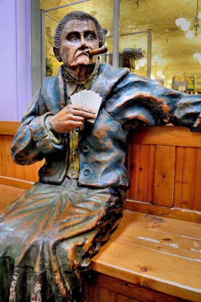
“If you can’t beat ‘em, join ‘em.” This might have been the motto of a traveling-show marksman named Frank Butler. He lost a high-stakes shooting contest to 15 year-old Phoebe Ann Mosey in 1875. He married the future Annie Oakley the following year. They went on to fame in the Buffalo Bill’s Wild West Show. She continued setting shooting records until her death at 66. This hand-carved, cedar sculpture of Annie sitting on a bench with playing cards and smoking a cigar is in the equally iconic Wall Drug Store in Wall, South Dakota.
510 Main St, Wall, SD 57790 Enlarge/Slideshow See On Map Directions