Come find the Lost City of Petra. You will be awed by hundreds of rock-cut buildings from an ancient civilization. This top tourist destination in Jordan is a New 7 Wonders of the World and a UNESCO World Heritage Site.
Come find the Lost City of Petra. You will be awed by hundreds of rock-cut buildings from an ancient civilization. This top tourist destination in Jordan is a New 7 Wonders of the World and a UNESCO World Heritage Site.
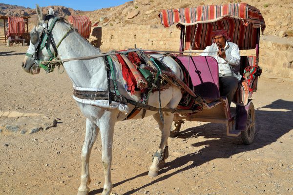
When you arrive at Petra, a local Bedouin will offer you a ride in his horse-drawn buggy through a valley called Bab as-Siq and then through the Siq passage to the start of the ancient city. If you decline, then several other drivers will try to convince you. It is something to consider. The walk is not far or strenuous. But this is inexpensive fun and you will reach your destination faster. Besides, you will do plenty of walking while exploring the archeological site.
Petra Guest House Tourism St 28, Petra, Jordan Enlarge/Slideshow See On Map Directions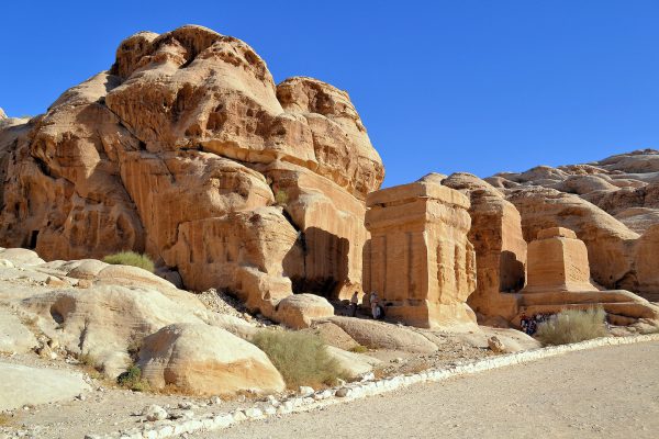
Excitement mounts as you reach these three, 19 to 26 foot square, monolithic stones called Djinn Blocks. These former tombs now mark the boundary of the Petra Archaeological Park. The PAP consists of 2.8 million square feet of a Nabataean city that is over 2,000 years old. The entire archeological site has been a UNESCO World Heritage Site since 1985. It was also named one of the New 7 Wonders of the World in 2007. The ancient civilization you are about to see exceeds those distinctions. You will soon know why Petra is Jordan’s number one visited attraction.
Petra Guest House Tourism St 28, Petra, Jordan Enlarge/Slideshow See On Map Directions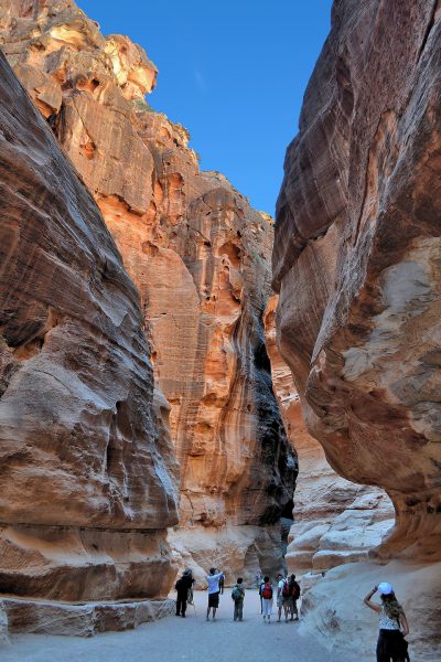
Your Petra journey begins with a one kilometer walk through a very narrow mountain gorge named The Siq. The sandstone walls envelop you as they tower to a height of 650 feet. When the sun finds its way through the passage, it illuminates the swirls of colors painted by millenniums of erosion from floods and wind. This has served as the primary entrance to Petra since at least the 1st century BC.
al-Siq, Petra, Jordan Enlarge/Slideshow See On Map Directions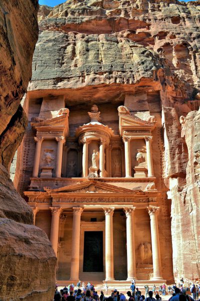
The word “breathtaking” is often overused. Yet it is the perfect way to describe seeing Al-Khazneh as you exit The Siq. This rose-colored, classic façade has a dozen columns, Corinthian capitals plus statues of gods and goddesses. 2,000 years ago it was a temple or royal tomb. It has also been called The Treasury of the Pharaoh. This is based on a legend that an Egyptian king buried his treasures inside of the crown-shaped urn while pursing the Israelites during the Exodus. In the center niche is a statue of Al-‘Uzzá. “The Most Mighty” was the Arabian goddess of love and the protector of Petra. Also notice the small horizontal lines flanking the second story. These were ladders used during The Treasury’s construction.
Al-Khazneh al-Siq St, Petra, Jordan Enlarge/Slideshow See On Map Directions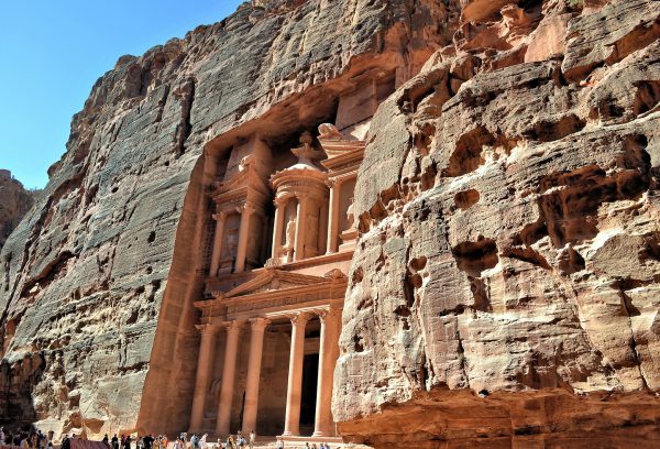
Al-Khazneh is a magnificent example of 1st century Nabataean architecture and the most photographed façade in Jordan. The 141 foot tall Treasury was carved into a massive cliff along the valley of Wadi Musa. Some believe this Valley of Moses is near where the prophet miraculously drew water from a rock during the Exodus. The Treasury is also where Harrison Ford sought the Holy Grail during the climax of “Indiana Jones and the Last Crusade.”
Al-Khazneh al-Siq St, Petra, Jordan Enlarge/Slideshow See On Map Directions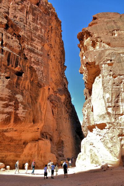
The capital city of the Nabataean Kingdom (168 BC – 106 AD) was named Raqmu. It is now called Petra. This is a derivative of the Greek word “petros” meaning stone or rock. In 1845, John William Burgon described Petra in a poem as, “A rose-red city half as old as time.” But you can just call it “spectacular” as you see more of the 800 ancient monuments and buildings. Your journey continues along a passage formed by the Jabal al-Kubtha mountain on the right.
Al-khazneh, al-siq, Petra, Jordan Enlarge/Slideshow See On Map Directions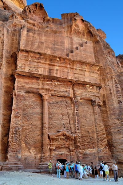
First inhabited around 7,000 BC (perhaps much earlier), the Wadi Musa mountain and valley are where Moses led the Israelites during the Exodus and buried his brother Aaron. The Nabataeans, a nomadic tribe of Arabs, may have settled here during the 6th century BC. Their kingdom emerged during the 2nd century BC. They proceeded to carve hundreds of magnificent tombs into mountains while thriving as a major trade center. In 106 AD, they succumbed to the Roman Empire. The Romans built impressive temples, streets, theaters and arched gates while the population grew to over 20,000 people. During the Byzantine Era, this ancient city was plagued with earthquakes and then conquered in the mid-7th century. These events caused the inhabitants to abandon the city except for a few Crusaders in the 12th century and later Bedouin cave dwellers. The Rose-Red City was rediscovered by Johann Ludwig Burckhardt in 1812. Now is your chance to discover one of the New 7 Wonders of the World.
Street of Facades, Petra, Jordan Enlarge/Slideshow See On Map Directions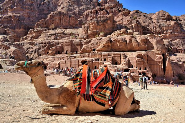
This camel is resting in the sun along the Street of Façades. This was the core of Raqmu during Nabataean times before the Romans arrived early in the 2nd century. The cliffs defining this avenue are filled with mausoleums. Some date back to the 3rd century BC and perhaps earlier. The most famous tomb in the area is Aaron’s grave, the older brother of the prophet Moses. After the Exodus circa 1446 BC, Haroun died at the age of 123 and was reportedly buried about three miles away at the top of Jabal Haroun, also called Aaron’s Mountain.
Street of Facades, Petra, Jordan Enlarge/Slideshow See On Map Directions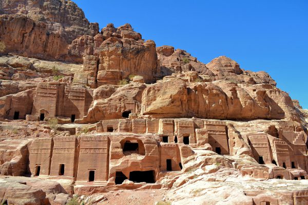
There are over 625 rock-cut tombs in the center of Petra and a large percentage of them are found facing the Street of Façades. Their size, carvings and features hints at the importance of the person or family buried inside. These rows of sandstone monuments are impressive. Imagine how spectacular they appeared millenniums ago when they were covered with painted plaster.
Street of Facades, Petra, Jordan Enlarge/Slideshow See On Map Directions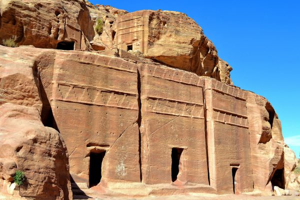
There are eight designs of tombs in Nabataean architecture. They are distinguished by the complexity of their carvings and whether they have columns, pediments or arches. The pattern on these three tombs along the Street of Facades is called Double Pylon. This monument type averages 17 feet across but can measure up to 50 feet wide. Notice their two rows of the crowstep motif. Over 80% of the burial monuments at Petra have some variation of this geometrical design.
Street of Facades, Petra, Jordan Enlarge/Slideshow See On Map Directions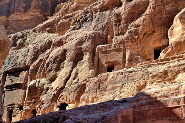
Here are three more designs of Nabataean stone-cut tombs. From left to right they are Step, Arch and Single Pylon. These tend to be the smallest of the tombs found in the ancient city. The fourth tomb in the right corner has no distinguishing marks. Most of the burial monuments at Petra were probably built between 50 BC and 129 AD. This roughly correlates to the height of the Nabataean Kingdom.
Street of Facades, Petra, Jordan Enlarge/Slideshow See On Map Directions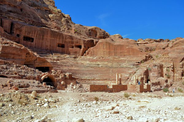
There are three theaters in Petra. The most impressive one is the Main Theatre. It was carved into the side of a cliff called Jabal Al-Madbah at the base of the High Place of Sacrifice. This auditorium was commissioned by Nabataean King Aretas IV (9 BC – 40 AD). He was known as the “Friend of His People.” The 2,000 foot stadium accommodated 4,000 spectators.
Street of Facades, Petra, Jordan Enlarge/Slideshow See On Map Directions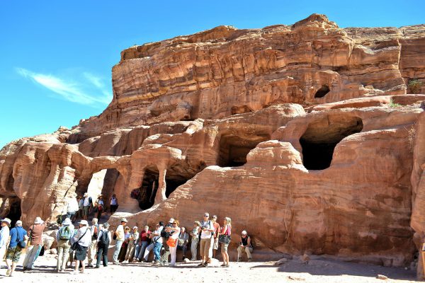
These people are standing next to a simple tomb carved into a ridge. Tourists enjoy exploring these shallow caves while workers and their animals often use them as a respite from the heat. Most visitors to Petra are part of a tour group. A minimum visit should be about four hours. However, the curious can easily spend a day or two exploring the ruins of this ancient city.
Street of Facades, Petra, Jordan Enlarge/Slideshow See On Map Directions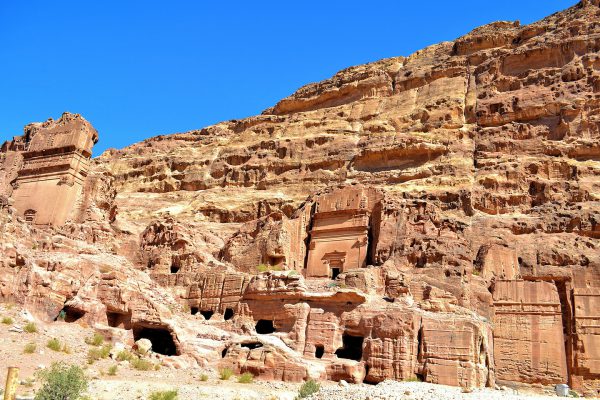
On the left is the Aneisho Tomb. The name comes from the inscription found nearby, presumably the surname of the family once buried inside. The tomb’s tall façade flanked by two columns with a double cornice is called a Hegr design. On the right is a much smaller version of the same architectural style. Historians believe the Uneishu Tomb was built for the “brother” or chief minister of Shaqilath II, a Nabataean queen. It was constructed around 76 AD.
Street of Facades, Petra, Jordan Enlarge/Slideshow See On Map Directions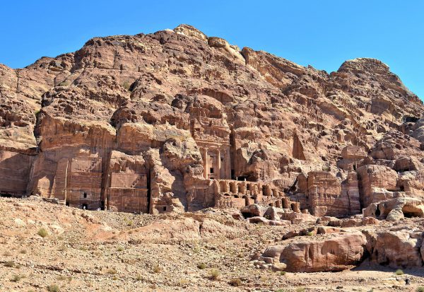
There are four majestic Royal Temples carved into the face of the Jabal al-Khubtha. The largest is the Urn Tomb in the center of this photo. The impressive, Complex Classical style includes columns and an urn-shaped ornamentation above the pediment. It was finished in 70 AD as a crypt for Nabataean King Malchus II. The monument was converted into a Byzantine church during the mid-5th century. The two-story arcade beneath it is a vault called the sijin which means prison. To the left is an unidentified tomb with a Step design. On the far left is the Silk Tomb, so named because of the bright, swirling colors on its façade. It was built during the 1st century.
Street of Facades, Petra, Jordan Enlarge/Slideshow See On Map Directions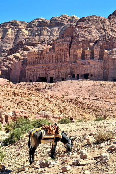
This donkey is grazing in front of two of the four Royal Tombs. This row is sometimes called the East Ridge or Kings’ Wall. Notice the badly eroded columns on the right. These gave the burial monument its name: Corinthian Tomb. The final resting place for King Aretas IV was sculpted into the mountainside during the subsequent reign of King Malichus II (40 – 70 AD). Then his successor and the last Nabataean ruler, King Rabbel II (70 – 106 AD), built The Palace Tomb on the left. Its Complex Classical style across three floors is one of the most impressive buildings in Petra. Measuring over 160 feet wide, this monument shares several of the design elements of The Treasury.
Street of Facades, Petra, Jordan Enlarge/Slideshow See On Map Directions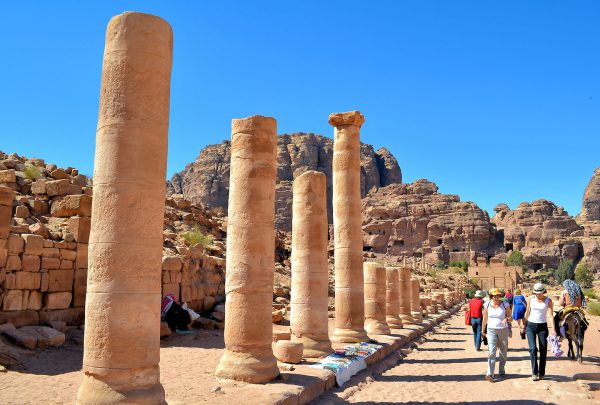
From the Main Theater to the Qasa Al-Bint (background) is the Colonnaded Street. The ancient shops once flanking this avenue are gone or are in ruins. However, you will find a modern archaeological museum and a restaurant along this pedestrian walkway. The Cardo Maximus was built by the Romans after they took control of Petra in 106 AD. That year marked the end of the Nabataean Era. The city then became part of the Roman Empire’s Provincia Arabia.
Colonnaded St, Petra, Jordan Enlarge/Slideshow See On Map Directions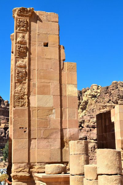
At the end of the Colonnaded Street and next to the Qasa Al-Bint are the ruins of a large Greco-Roman gate. Called Hadrian’s Gate by some and the Temenos Gate by others, this ceremonial entrance to the sacred section (temenos) of town once had three impressive arches. Notice the square ornamental reliefs. They are Nabataean motifs. This suggests a period of architectural if not political compatibility between the two empires during the early 2nd century annexation of Petra to the Romans.
Colonnaded St, Petra, Jordan Enlarge/Slideshow See On Map Directions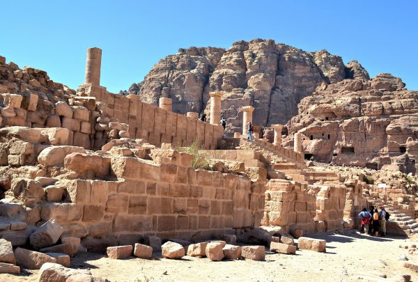
The Great Temple of Petra should be called the Enormous Temple because it measures 117 by 460 feet. This retaining wall of large Ashlars block is called a propylaeum. This means the structure forming the temple’s entrance. The staircase leads to the Lower Temenos. This first level courtyard is surrounded on three sides with the remnants of about 35 columns.
Colonnaded St, Petra, Jordan Enlarge/Slideshow See On Map Directions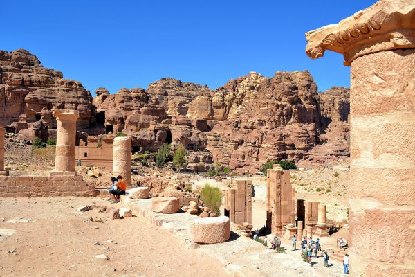
The Great Temple may have been improperly named because scholars are not convinced it was used for religious purposes. This first level, called the Lower Temenos, may have been a covered marketplace or forum. It was built in the 1st century AD during the temple’s second phase of construction. The Upper Temenos contained a theater (Theatron) or meeting hall. It was constructed during the 1st century BC. This entire structure fell into ruins during an earthquake in 363 AD. Hadrian’s Gate is in the right corner of this photo. Also notice the background structure between the two left columns. That is part of the Qasa Al-Bint Temple’s wall.
Colonnaded St, Petra, Jordan Enlarge/Slideshow See On Map Directions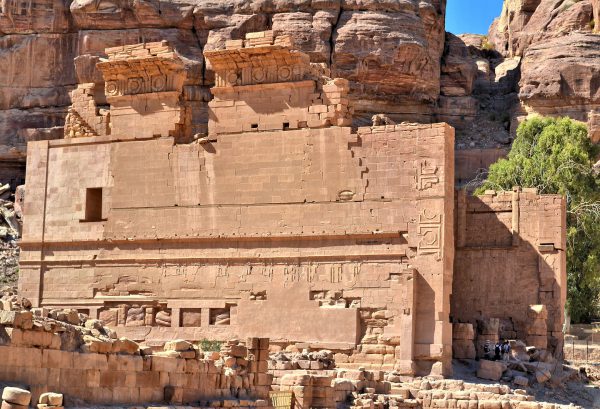
The Qasa Al-Bint must have been impressive during the 1st century BC when it was covered with marble. The temple’s walls measure 196 feet wide and 76 feet tall. Several scholars believe the temple was dedicated to Dushara. Also spelled Dusares or Dushares, he was the supreme Nabataean god and the Lord of the Shara Mountains. Others speculate the Palace of the Pharaoh’s Daughter honored Al-‘Uzza, the goddess of power. This temple is one of the few free-standing buildings you will see at Petra. The majority were destroyed during earthquakes in 363 and 747 AD. In contrast, most of the Nabataean tombs were spared because they were carved into cliffs.
Colonnaded St, Petra, Jordan Enlarge/Slideshow See On Map Directions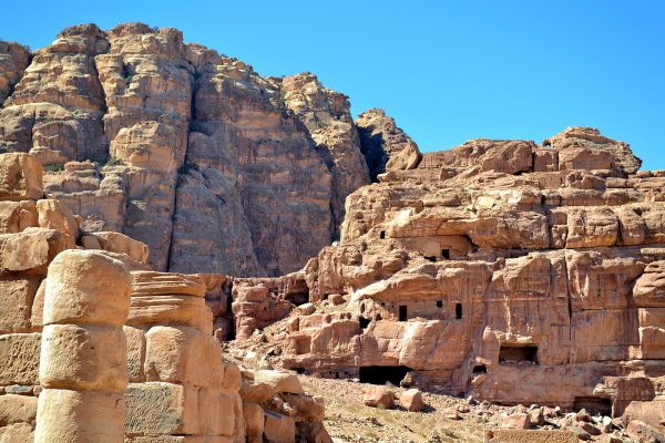
Dwarfed by the much larger Umm al-Beyyara mountain on the left, the Jebal Habis mount on the right is far more fascinating. The face of the cliff shows evidence of an enormous and elaborate unfinished tomb. Had it been completed, it would have been one of the largest burial monuments in Petra. Less visible in this photo are the ruins of a Crusaders castle at the peak. The al-Habis fortress was built in 1115 AD but is now mostly in ruins.
Colonnaded St, Petra, Jordan Enlarge/Slideshow See On Map Directions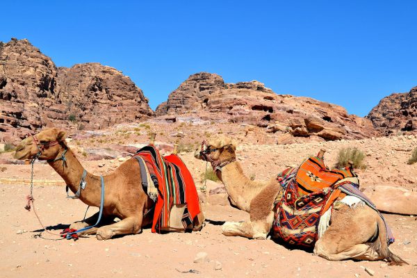
You will see lots of camels at Petra. They are available for a photo op or a rather unique ride. Although they are a tourist prop today, the camel was the form of transportation for the nomadic lifestyle of the early Nabataeans. They were also the primary work animal when Petra was a caravan center for trade routes from northern Jordan to southern Arabia including Egypt.
Colonnaded St, Petra, Jordan Enlarge/Slideshow See On Map Directions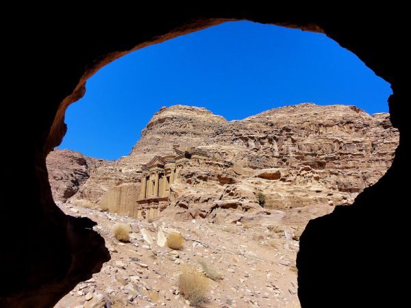
Most people envision The Treasury as the symbol of Petra. However, the two-story Monastery (seen here from inside a cave) is almost as ornate and is considerably larger at 155 by 158 feet. Built during the middle of the first century, it is believed ad-Deir is a monument to King Obodas I. The “King of the Arabs” reigned from 96 until 85 BC. His cult used the structure as a meeting hall and dining room (called a triclinium) in honor of the deified king. The name Deir stems from the Hermit’s Cell nearby.
The Monastery, Ad Deir, Petra, Jordan Enlarge/Slideshow See On Map Directions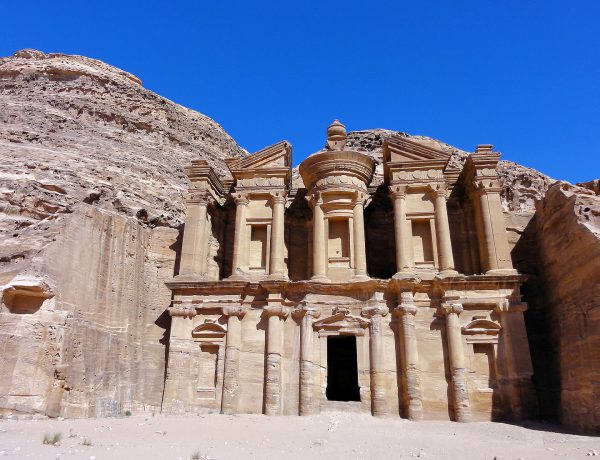
You must walk along a cliff hugging pathway and climb 800 narrow steps to reach the al-Deir Plateau. If this sounds too hard, you can hitch a ride on a donkey for a negotiated fee. This sounds like fun at first but quickly feels treacherous. But when you arrive at this dusty courtyard, your pilgrimage is worth this magnificent view. The name Monastery is derived from when this building was converted into a Christian church during the Byzantine Period.
The Monastery, Ad Deir, Petra, Jordan Enlarge/Slideshow See On Map Directions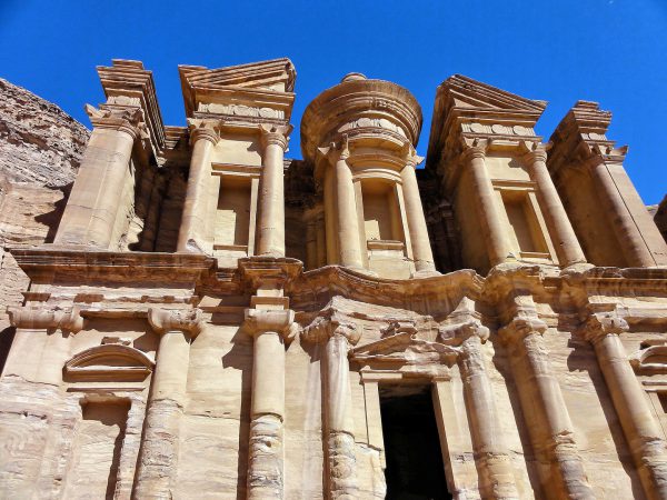
The Complex Classical design of The Monastery deserves a close inspection. In many ways it is a simpler version of The Treasury. Its features include 16 columns of different sizes and capital styles. The two lower square niches are topped with an arch, the upper level ones have a simple cornice and over the door is a pediment. In the center is a large urn. Surrounding this finial is a frieze with a reoccurring relief of circles. Although its design hints of a Roman influence, it is actually Alexandrian.
The Monastery, Ad Deir, Petra, Jordan Enlarge/Slideshow See On Map Directions