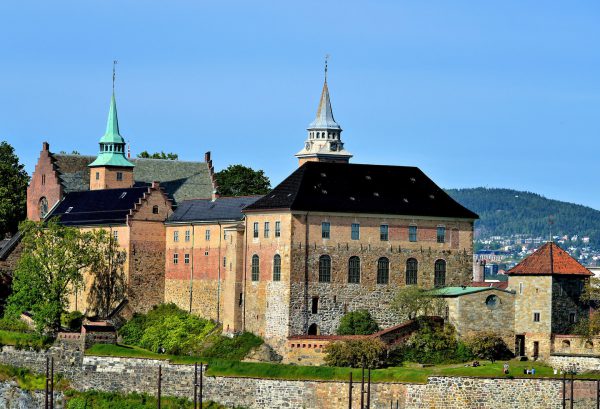
Akershus Fortress was constructed along the coastline of the Oslo Fjord around 1299 as a defense against sea and land invasions. Akershus Festning successfully repelled at least six attacks by Swedish, Danish and Scottish soldiers from 1308 through the 16th century. The citadel was only surrendered in 1940 when Germany invaded Norway during WWII. The Germans used the big building on the right, called the Akershus National Penitentiary, as a military prison. Further on the right is the Crown Prince’s Powder Magazine Tower (circa 1755). It was used by the Nazis as death row for Norwegian Resistance fighters. The castle was liberated in 1945. Akershus Fortress is surrounded by Crown Prince’s Bastion, a stone wall built in 1618.
Akershus Castle Church 0150 Oslo, Norway Enlarge/Slideshow See On Map Directions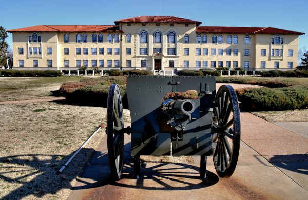
Fort Sill in Lawton, Oklahoma, was built in 1869 during the Indian wars. The property is still an active Army post. The artillery museum displays guns and uniforms dating back to 1775. The exhibits include this 76 mm Regimental Gun used in 1927. Also on the grounds are the burial sites of Indian prisoners. The most famous one is the grave of Geronimo, a leader of the Chiricahua Apache tribe. He lived from 1829 until 1909.
455 McNair Rd #118, Fort Sill, OK 73503 Enlarge/Slideshow See On Map Directions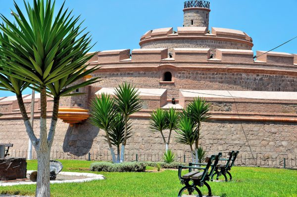
When Spaniards began using the port of Callao in 1535 to load their ships with treasures to return to Spain, they attracted buccaneers. The pirating began with Sir Frances Drake in 1578. The Viceroy of Peru, José Antonio Manso de Velasco, commissioned Louis Godin to build a fortress after the previous defense was destroyed in the 1746 earthquake. The Real Felipe, named after King Phillip V of Spain, was finished in 1774. The pentagon-shaped citadel has five bastions with cannons pointing out from the battlements.
Pileta Paz Soldan, Callao 07021, Peru Enlarge/Slideshow See On Map Directions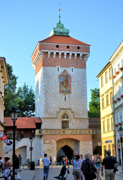
In response to three attacks by the Mongols during the 13th century, a massive wall was built around Kraków. By the end of the 15th century, the stone defensives measured 33 feet high and eight feet thick. There were 47 towers and eight gates along its nearly two mile length. In 1804, the Austrians ordered the destruction of the medieval fortification. St. Florian’s Gate and three neighboring towers were spared. This Gothic tower was once the main gate into Kraków. As the start of the Royal Road used during major processions, it earned the colloquial name of Gate of Glory. Brama Floriańska was built in 1307 and stands 113 feet. The colorful bas-relief in the center depicts Saint Florian. He was martyred in 304 AD during the persecution of Christians by Roman Emperor Diocletian.
Brama Floriańska, Floriańska, 31-019 Kraków, Poland Enlarge/Slideshow See On Map Directions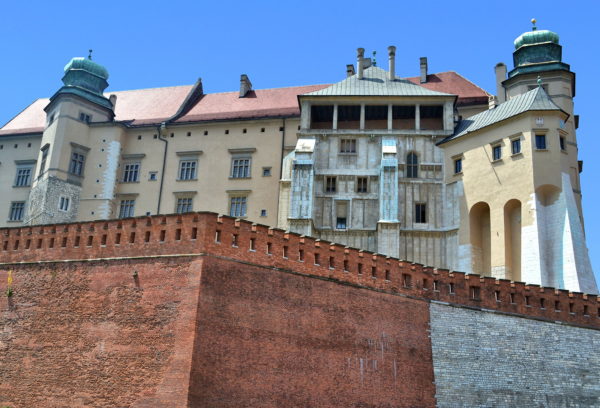
Mieszko I was ruler of the Polans from 960 until 992. During his reign over territories that would later become Poland, he selected a 15-acre limestone outcrop along the Vistula river to build his residence. For nearly 600 years, the elevated site evolved into a large, fortified complex including Wawel Cathedral and Wawel Royal Castle. Wawel Hill was the location for subsequent Polish kings and the center of political power until the capital was moved to Warsaw in 1569. Wawel Royal Castle is an architectural history book of Poland. Each section has a fascinating story. This is the eastern approach. The structures seen above the massive curtainwall are, left to right: Jordan Tower, Danish Tower, Hen’s Foot and Sigismund Vasa’s Tower. They represent nearly 250 years of additions to the castle from the reign of Władysław II Jagiełło (1377 – 1434) through Sigismund III Vasa (1587 – 1632).
Wawel Royal Castle, Wawel 5, 31-001 Kraków, Poland Enlarge/Slideshow See On Map Directions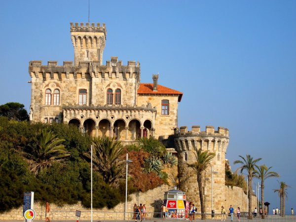
The full name of this fortress along Tamariz Beach is the Fort of Santo António da Cruz. It was created as a residence in the late 19th century by a wealthy man named João Martins de Barra. Apparently he built it for his terminally ill daughter but I am sure he also loved the wonderful view of the Atlantic Ocean.
R. Olivença 13, 2765-262 Estoril, Portugal Enlarge/Slideshow See On Map Directions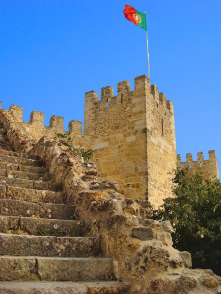
If only this watch tower could tell about the history it has seen. It is part of the Castelo de São Jorge which dates back to the 10th century. However, at least ten nationalities of people have built fortifications on this same hill overlooking Lisbon, Portugal, since the 6th century B.C.
Castelo de S. Jorge R. de Santa Cruz do Castelo, 1100-129 Lisboa, Portugal Enlarge/Slideshow See On Map Directions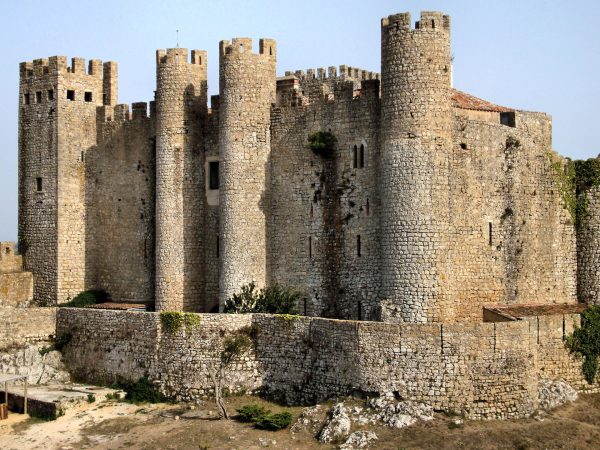
The Óbidos Castle was first built by the Moors during their occupation of Portugal starting in 713 AD. It was reclaimed by King Afonso Henriques in 1148. The Medieval citadel and its surrounding walls were then rebuilt and enhanced during the 13th, 14th and 20th centuries.
Estr. da Cerca, 2510-999 Óbidos, Portugal Enlarge/Slideshow See On Map Directions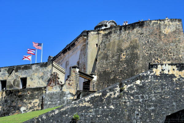
During the 16th through the 18th centuries, the Spanish built countless fortresses in the Caribbean and South America. The largest was Castillo San Cristóbal (Saint Christopher Fort). This formidable defense spanned 27 acres of Old San Juan. Fort San Cristóbal was constructed from 1765 until 1783, a remarkably short time for such a huge undertaking. The citadel engaged in battle twice. The first was in 1797 when a British onslaught was repelled. The second was 101 years later when their cannons fired against the USS Yale. This ill-fated move engaged Puerto Rico into the Spanish-American War. Before the end of the year, Spain ceded Puerto Rico to the United States in the Treaty of Paris. Notice the three flags. They represent the United States, Puerto Rico and the Spanish Empire. Do not miss visiting this San Juan National Historic Site. The fort is also designated a UNESCO World Heritage Site.
Castillo San Cristóbal, 501 Calle Norzagaray, San Juan, 00901, Puerto Rico Enlarge/Slideshow See On Map Directions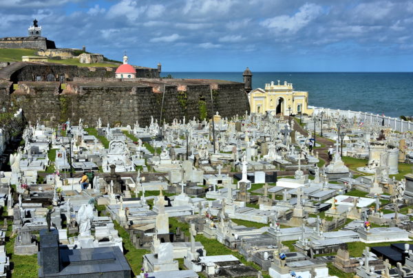
Castillo San Felipe del Morro is the uncontested highlight of Old San Juan. Before starting your exploration of this San Juan National Historic Site, become familiar with the surrounding landmarks. In the upper left corner is the lighthouse in the middle of El Morro, the old Spanish fort. Side-by-side on the hill are the San Antonio Bastion Guardhouse (1897) on the left and the Powder Magazine (1783) on the right. The middle masonry wall is San Antonio Bastion (1783) and the nearest crenelated wall is Santa Rosa Bastion (1783). The pink dome between them is the Cemetery Chapel (1862). In the foreground is Santa Maria Magdalena de Pazzis Cemetery (1814).
Calle Tiburcio Reyes, San Juan, 00901, Puerto Rico Enlarge/Slideshow See On Map Directions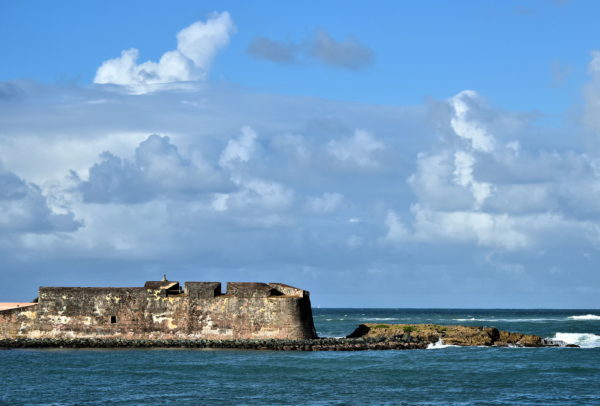
Visitors explore the walls and forts encircling Old San Juan but are often oblivious to other fortifications built by the Spaniards. In 1609, El Boquerón was constructed at the east end of the islet near the mouth of today’s Condado Lagoon. The four cannon defense battery was destroyed by privateers in the late 16th century. When the half-acre fortress was rebuilt, it was named Fortin de San Gerónimo de Boquerón. In 1797, San Gerónimo and the adjacent Fort of San Antonio were relentlessly bombarded by the British. Despite being grossly outnumbered and suffering crippling damage to their fort, the defenders repelled the attack. The citadel was rebuilt a couple years later and became a military post. This National Register of Historic Places property is now attached to the Caribe Hilton Hotel. Unfortunately, the historic site is closed because of its dilapidated condition.
1 Calle San Gerónimo, San Juan, 00907, Puerto Rico Enlarge/Slideshow See On Map Directions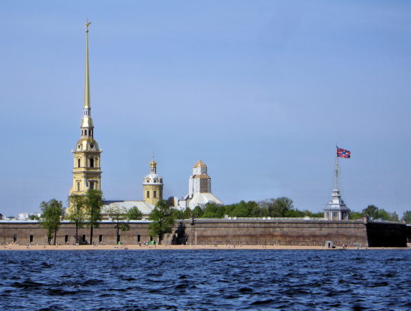
From 1700 to 1721, Peter the Great battled against the Swedish Empire during the Great Northern War. In 1703, he captured Nyenskans, an early 17th century Swedish fort at the head of the Gulf of Finland on the Neva River. He ordered the citadel to be rebuilt along with this one. Peter and Paul Fortress was constructed on Hare Island. Both were designed to protect his planned capital city, today’s Saint Petersburg. The Swedes never attacked the fort. A year before Peter I became Russia’s first Emperor in 1721, the fortress was converted into a prison. It maintained that role for nearly 200 years until it was liberated during the February Revolution in 1917. One month after this political uprising, the Russian Empire collapsed and its last emperor, Nicholas II, was executed. By the end of 1917, the Soviet Republic was proclaimed and Vladimir Ilyich Ulyanov (Lenin) was the leader.
Peter & Paul Fortress, Sankt-Peterburg, Russia, 197046 Enlarge/Slideshow See On Map Directions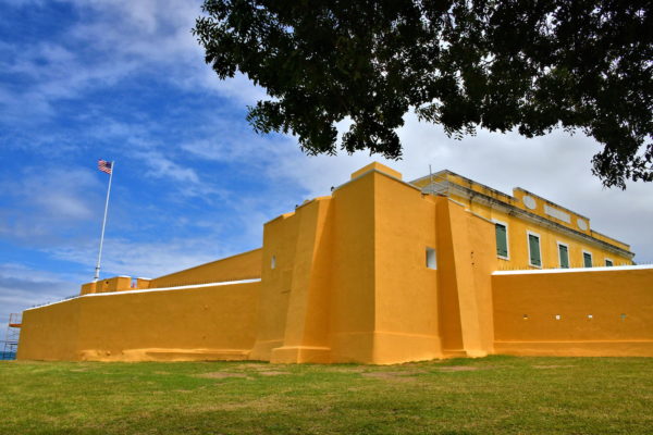
The Danes built Fort Christiansvaern from 1738 through 1749. Their goal was to protect the harbor and their fledgling settlement against potential attacks from the British, French, privateers and slaves. The cannons never fired a shot in battle. Fort Christiansvaern (Christian’s Defense) remains unchanged from colonial times except for an expansion from 1835 to 1841. After 1878, the fort was repurposed several times as a courthouse, prison and police headquarters. Today, it is a popular tourist attraction.
Hospital & Company Streets, Christiansted, St Croix 00820, USVI Enlarge/Slideshow See On Map Directions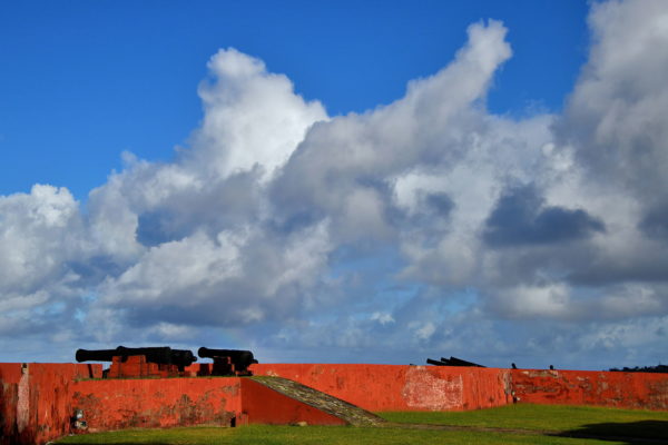
In 1733, the Danish West Indies Company purchased Saint Croix from France. After King Frederick secured full control in 1754, the Danes began constructing a trapezoidal defense to protect the deep-water port. Fort Frederik was finished in 1760. This battery of cannons still points toward the harbor. The Danish fortress never encountered a battle. However, Frederiksfort still holds an important role in the history of Saint Croix. In 1848, the emancipation proclamation was read here. In 1917, a ceremony marked the transfer of Saint Croix to the United States. Fort Frederik is now a fascinating museum.
Fort Frederik, Frederiksted, St Croix 00840, USVI Enlarge/Slideshow See On Map Directions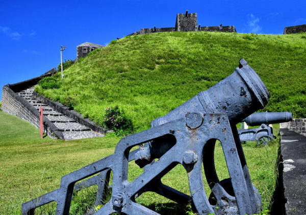
Anticipation starts growing when you notice Brimstone Hill, the historical apex of Saint Kitts. The 755 foot mountain stands guard over the northwest coast. Excitement melts into trepidation as your driver cautiously navigates a switchback road, honks at every turn, squeezes through the front gate and parks in the old parade ground. Encircling you are 38 acres of Brimstone Hill Fortress National Park. This British fort was first armed in 1690, fortified for over a century and then abandoned in 1852. Brimstone Hill Fortress was once called the Gibraltar of the West Indies because it was considered impenetrable. The French proved that assumption wrong in 1782. Today, this is one of the best maintained forts in the Americas and worthy of its UNESCO World Heritage Site designation. Now walk up the ramp to reach the Western Place of Arms, cross a moat and enter the Citadel of Fort George.
Brimstone Hill Fortress, Sandy Point, St. Kitts & Nevis Enlarge/Slideshow See On Map Directions
Estimates suggest the French and British collectively built more than 50 defenses with the goal of protecting Castries Harbor. This one at the northern entrance is Meadow’s Battery. The military installment was created by the British in 1898. Among the ruins are the remains of a bathhouse, women’s quarters, bunkers, an armory for artillery shells and this two-tier battery platform overlooking the Caribbean Sea.
Meadow's Battery, Clarke Ave, Castries, St. Lucia Enlarge/Slideshow See On Map Directions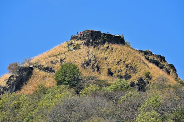
From 1650 until the late 18th century, the French controlled Pigeon Island. They were expelled by the British during the Battle of Cul-de-Sac in 1778. Then, Admiral Sir George Rodney built a fortification on the smaller of the two island’s peaks. From here he launched his fleet of ships in several attacks against the French. The most famous and decisive was the Battle of the Saintes in 1782. It is worth visiting the ruins of Fort Rodeny to see the old cannons, stone walls and panoramic views of the Caribbean Sea and the Atlantic Ocean.
Pigeon Island National Park, Gros Islet, St. Lucia Enlarge/Slideshow See On Map Directions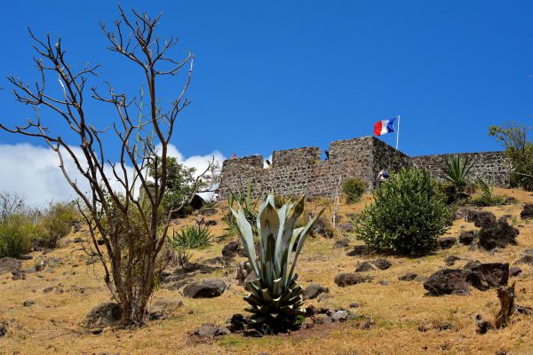
The island has several historic forts. The largest is Fort Marigot overlooking the French capital city. Its walls are well maintained and there are several cannons pointing out of the battlements. When it was built in 1789, it was named Le Fort Louis in honor of Louis XVI. He was the King of France from 1774 until 1791. After he was guillotined for treason in 1793, the system of monarchs in France ended.
Rue du Fort St Louis, Marigot, St Martin Enlarge/Slideshow See On Map Directions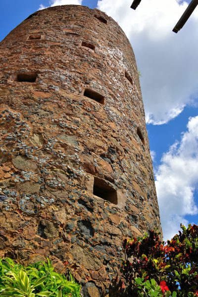
For a small entrance fee, you can tour Blackbeard’s Castle and other historic buildings in the King’s Quarter of Charlotte Amalie. Although I highly recommend the tour, the name is a misnomer. First, the Skytsborg Tower was built as part of a Danish fort in 1680, the same year the pirate was born as Edward Teach or Thatch. Second, although Blackbeard did plunder ships along the Lesser Antilles, some historians believe he never set foot on St. Thomas. However, several other pirates and bootleggers did have a safe haven on the island at the turn of the 17th century. So what is fact versus fiction is murky but the view from the top is worth climbing up the 40 foot circular staircase.
Blackbeard's Castle, 1002 Blackbeard's Hill, Charlotte Amalie, St Thomas 00802, USVI Enlarge/Slideshow See On Map Directions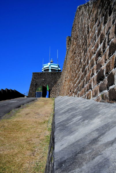
The Seven Years’ War ended in 1763 with the Treaty of Paris. As part of the agreement, France ceded many colonies in the Americas to Great Britain including Saint Vincent. The British immediately began building a fortification near Kingstown. They named it Fort Charlotte in honor of King George III’s wife. During the 43 years of construction – from 1763 until 1806 – the island witnessed several battles between the British and Indigenous people. Most noteworthy were the First Carib War (1769 – 1773) and battles with the Black Caribs (1793 – 1796). In between these events, the British lost control of Saint Vincent to the French from 1779 and 1783. In short, the colonial years during the second half of the 18th century were tumultuous at best.
Fort Charlotte, Edinboro Road, Clare Valley, St. Vincent & Grenadines Enlarge/Slideshow See On Map Directions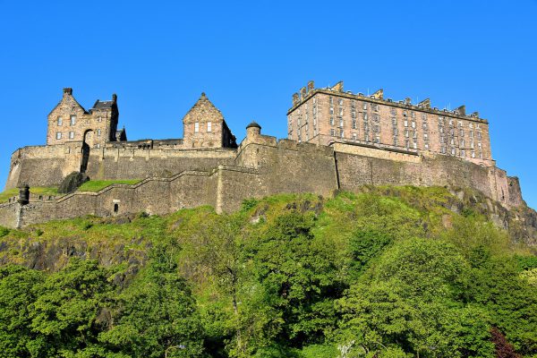
Evidence suggests this former volcanic plug was inhabited back in the Bronze Age. The oldest structure within the current fortress was commissioned by King David I of Scotland, who reigned from 1124 until 1153. He built St. Margaret’s Chapel in 1130 as a tribute to his mother. It still stands within this enormous fortress. The castle was expanded and rebuilt numerous times while serving as the residence for monarchs until 1633. During its history, it was attacked over 25 times and occasionally succumbed during battle. Portions of the fort were a prison until 1814. It also was as a military garrison until 1923 yet remains an active military base. This southwestern view shows (from left to right) the Hospital, Butts Battery, National War Museum and the New Barracks which also contains the Royal Scots Dragoon Guards Regimental Museum.
Castlehill, Edinburgh EH1 2NG, UK Enlarge/Slideshow See On Map Directions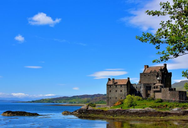
The Eilean Donan Castle is located on a small island at the juncture of three lochs: Duich, Long and Aish. Its namesake is Saint Donnán of Eigg, a 7th century Irish priest. The first fortification was built here during the early 13th century by the Scottish nobles called Lord of the Isles. Late in the 1200s, it was owned by Clan Mackenzie. The Mackenzies expanded the fort and maintained control for centuries despite several battles among neighboring clans. The castle met its fate during the Jacobite rising of 1719. After three ships from the Royal Navy bombarded the castle from sea, they completely destroyed the Eilean Donan using 27 barrels of gunpowder. It was rebuilt during the early 20th century.
A87 Kyle IV40, UK Enlarge/Slideshow See On Map Directions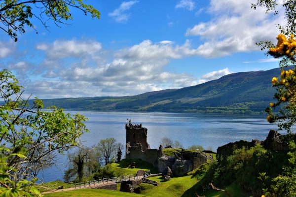
This view of Urquhart Castle overlooking Loch Ness makes it easy to see why this site was selected to build a citadel during the 6th century. In 1233, Alan Durward was granted the land by Alexander III, King of the Scots. He was the first to begin building the current Urquhart Castle. The fortress was the scene of several expansions, battles and owners until it was purposefully destroyed in 1692 by William of Orange’s army to prevent it from being used during the Jacobite risings (1689 – 1759).
A82 Inverness IV63 6XL, UK Enlarge/Slideshow See On Map Directions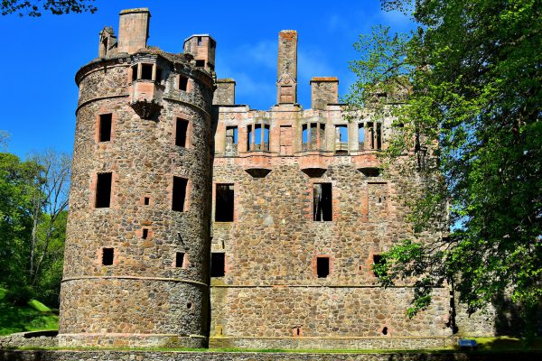
Strathbogie was the first castle built on this site during the late-12th century. The Fifes of Strathbogie surrendered it after the Battle of Bannockburn in 1314. Six years later, Robert the Bruce, King of the Scotts, gifted it to Sir Adam de Gordon in appreciation for negotiating a reconciliation with Pope John XXII. After the citadel was destroyed by the Earl of Moray in the mid-15th century, the current castle was constructed. It was expanded and repeatedly defended by the Clan Gordon for two hundred years until 1650. The castle exchanged hands several times during the Jacobite risings (1688 through 1746), a series of battles aimed at returning the House of Stuart to Great Britain’s throne. After the Battle of Culloden ended the rebellion, Huntly castle slowly fell into ruins.
1 Castle Gardens, Huntly AB54 4SH, UK Enlarge/Slideshow See On Map Directions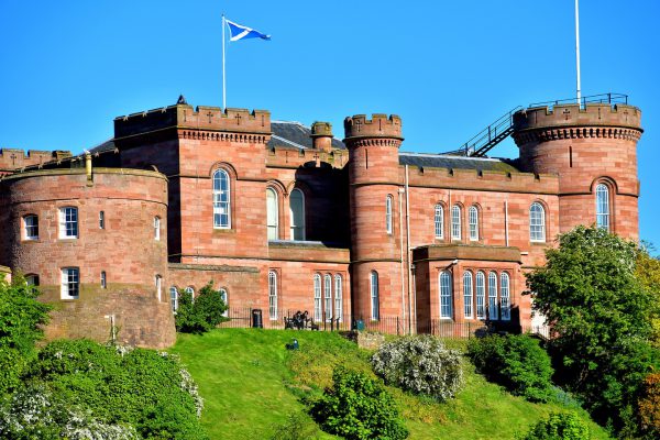
Malcolm III, the King of Scots, was the first to build a fortress on Castle Hill during the mid-11th century. This strategic position then witnessed a series of attacks and reconstructions through the mid-18th century. It was finally destroyed by the Jacobite army in 1746. The current sandstone citadel was designed by William Burn and finished in 1836. Today it is the Sheriff’s Court.
41 Castle St, Inverness IV2 3EG, UK Enlarge/Slideshow See On Map Directions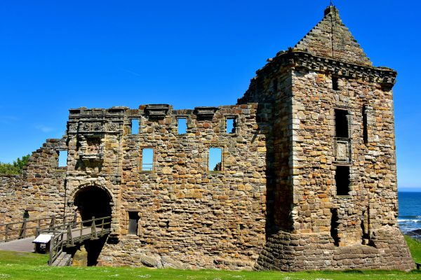
Since the 12th century, this castle was the home for local bishops, royalty and an infamous prison. The landmark also witnessed executions and assassinations plus was the scene of numerous battles. This side view of St Andrews Castle is called the Hamilton Façade. Note the wooden bridge leading into the citadel’s entrance. This wing was built by Archbishop John Hamilton in the mid-16th century. The castle was abandoned about 20 years after the archbishop was hung in 1571.
32 E Scores, St Andrews KY16 9BE, UK Enlarge/Slideshow See On Map Directions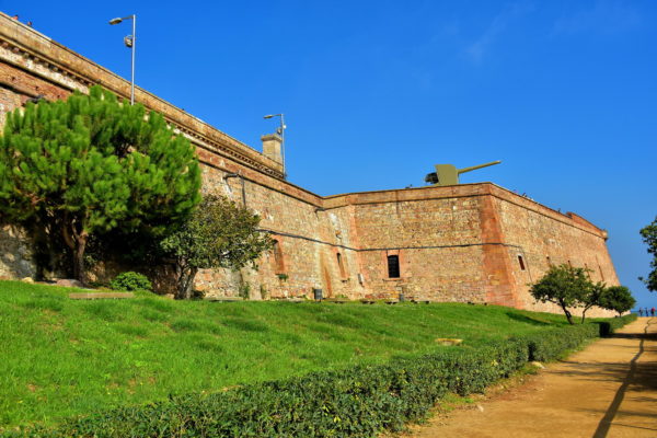
The first military fortress commanding Montjuïc Hill was built from 1640 until 1694. It saw fierce action in 1641 during the Battle of Montjuïc (part of the Catalan Revolt) and again in 1705 during the Siege of Barcelona. In the second half of the 18th century, architect Juan Martin Cermeño rebuilt the citadel. During the Spanish Civil War (1936 to 1939), this was the scene of imprisonment and executions of political enemies of dictator Francisco Franco. In 2011, Montjuïc Castle was given back to the city and is now available for public touring.
Ctra. de Montjuïc, 66, 08038 Barcelona, Spain Enlarge/Slideshow See On Map Directions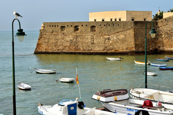
At the north end of La Caleta Beach is the Castle of Santa Catalina. This was one of the first defenses created by architect Cristóbal de Rojas after the city was pillaged in 1596. The fortress was finished two years later. The design includes a star-shaped layout protected by two bastions and a moat. The military also had a jail here. In 1693, the Chapel of Santa Catalina was built within the walls. Today, Castillo de Santa Catalina has a free museum with displays about the fortress. In the summertime there are concerts in the courtyard.
Castillo de Santa Catalina, Calle Campo de las Balas, 11002 Cádiz, Spain Enlarge/Slideshow See On Map Directions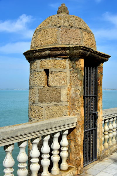
After Christopher Columbus launched his second and fourth voyages to the New World from Cádiz, the city began receiving treasures collected during the Age of Exploration. The prosperity of Cádiz grew exponentially. By the early 18th century, the Port of Cádiz managed 75% of the trade with the Americas. All that wealth attracted the greedy. The city was raided by Sir Frances Drake in 1587. Then the English destroyed Cádiz in 1596. In desperation, King Phillip II commissioned Cristóbal de Rojas to design an impenetrable defense. Within 25 years, the city was encircled by a curtainwall with intermittent guard towers and bastions armed with cannons. Castillo de Santa Catalina was also finished. Two bulwarks were added in the north part of town in the late 17th century. The construction of Castillo de San Sebastián followed in 1706. This exhaustive plan worked. The English attacked five times during the 17th and 18th centuries. As part of the Napoleonic Wars, the French assaulted Cádiz for two and a half years from 1810 until 1812. Each onslaught was successfully repelled. Most of these defenses are now yours to explore and enjoy.
Paseo de Sta. Barbara, 11003 Cádiz, Spain Enlarge/Slideshow See On Map Directions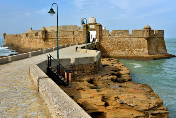
The islets you are approaching have a rich history. According to mythology, this site contained the Temple of Cronus. He was the Greek god of the Titans and father of Zeus. There is evidence a Muslim watchtower was here when the city was under Moorish rule from 711 until 1262. In 1457, a crew from a Venetian ship took refuge after contracting the plague. They dedicated their chapel to Saint Sebastian, a martyr from the 3rd century. When Cádiz was controlled by Spanish monarchs from the House of Habsburg, an artillery tower was placed on the larger island. After most of Cádiz was walled in during the 17th century, a fort was commissioned to defend the peninsula’s west end and La Caleta Beach. San Sebastián Castle was finished in 1706. About 250 years later, the walls around the outer islet were enhanced and new artillery was added. After being used as a prison during the 19th century, the fortress was abandoned.
Castillo de San Sebastián, 11002 Cádiz, Spain Enlarge/Slideshow See On Map Directions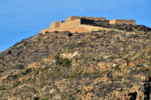
The 794 foot elevation of this hill overlooking Cartagena and its harbor has made it an ideal location for sentries since the Middle Ages. In Spanish, the name of the mount and fortress is Atalaya meaning watchtower. Fuerte de la Atalaya was built in 1777 during the massive fortification of Cartagena ordered by Spanish King Carlos III. The citadel is shaped as an isosceles trapezoid. The design includes six bastions. You can visit Atalaya Castle. However, reaching it can be challenging and much of the structure is in poor condition.
Pasaje Castle Atalaya, 1, 30205 Cartagena, Murcia, Spain Enlarge/Slideshow See On Map Directions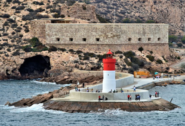
As the capabilities of naval warfare evolved, so did the defenses of Cartagena’s harbor. Christmas Fort began with a hexagonal tower in the 16th century, became a coastal battery in 1740 and was significantly expanded in 1860. At its peak, the fort was armed with 16 pieces of artillery. Many of them are still in place within the casemates. Fuerte de Navidad was abandoned in 1941. It is now a tourist attraction. During your visit, you will witness the lifestyle of the men stationed here. You can reach Christmas Fort by car or tourist boat. In the foreground is the 49 foot tall Dique de la Navidad Lighthouse. The Christmas Lighthouse was built on the breakwater in 1892.
Pasaje Faro Navidad, 2, 30394 Cartagena, Murcia, Spain Enlarge/Slideshow See On Map Directions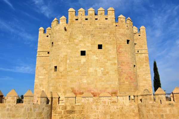
The Tower of Calahorra stands on the south bank of the Guadalquivir River near the entrance to the Roman Bridge. Two sections were constructed in the 12th century by Muslims when Córdoba was part of the Al-Andalus territory, also known as Islamic Iberia. The medieval fortress is now a history museum of that era (9th – 13th centuries) called the Al-Andalus Living Museum. The center section of the tower was added in the mid-14th century by Henry II. Enrique II was the first King of Castile and León from the House of Trastámara. His nemesis was his half-brother, Peter the Cruel, who he killed in 1369.
Periodista Alberto Almansa, 2, 14009 Córdoba, Spain Enlarge/Slideshow See On Map Directions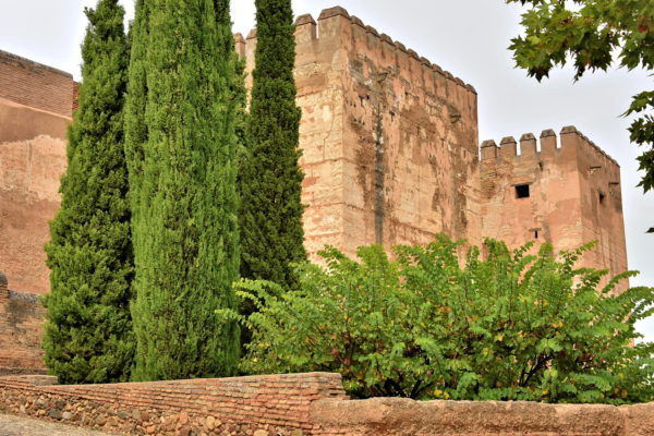
You are now standing in Plaza de los Aljibes. In Arabic, an aljibe is a cistern or well. So, this is the Square of the Cisterns. It received the name after Spanish nobleman Íñigo López de Mendoza y Quiñones, the Count of Tendilla, commissioned a 112 foot long well system in 1494. It is now buried beneath the esplanade. From this elevated vantage point, you can drink in views of the city and Albaicín, the old Muslim neighborhood. Looming over the cypress trees in this square are crenelated towers. These are part of the massive defensive wall built to protect the Alhambra from invaders. Behind them is the triangular Alcazaba. This Moorish military complex was constructed in the mid-13th century by the Nasrid dynasty on the foundation of a Roman fortress and a late-9th century citadel. The Alcazaba is well worth visiting.
Plaza Algibes Alhambra, 1T, 18009 Granada, Spain Enlarge/Slideshow See On Map Directions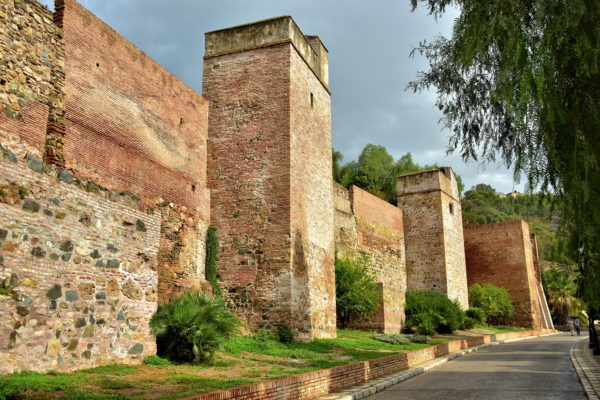
Moors began a westerly expansion across the southern sections of the Mediterranean Sea during the second half of the 7th century. By 711, the Umayyads claimed most of the Iberian Peninsula. This city was given the name Mālaqah. Control seesawed among Muslim dynasties for over 780 years until the collapse of the Nasrids and their Emirate of Granada in 1492. This event marked the end of the Reconquista and established Christian dominance. A significant timeframe for Málaga was from 1026 until 1279. During this period, rule over the city changed hands several times between isolated Moorish kingdoms (a tafia) and the Almoravids, a powerful Berber Muslim dynasty. In 1026, Yahya I al-Mu’tali of the Hammudid dynasty established the First Taifa of Málaga and declared it his capital. In 1057, Málaga was seized by Badis ibn Habús, the king of the Taifa of Granada. He immediately ordered the construction of a formidable fortress to protect his acquisition. This resulted in the initial construction of the Alcazaba from 1057 through 1063. Each conquering dynasty of Málaga – Almoravids in 1092, Almohads in 1146 and Nasrids in 1279 – reshaped and strengthened the Muslim fortification.
Paseo Don Juan Temboury, 29016 Málaga, Spain Enlarge/Slideshow See On Map Directions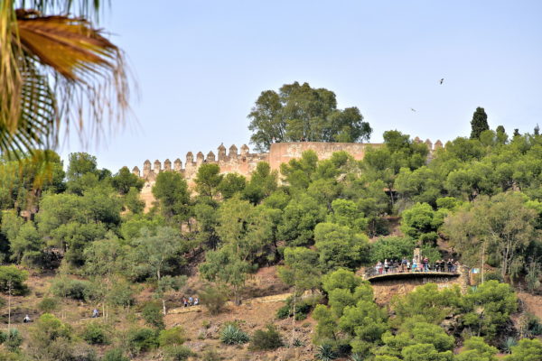
The highest point in central Málaga near the port is Jabal-Faruk, Arabic for Lighthouse Mountain. The Phoenicians used this summit as a fortified lookout during the 8th century BC followed by the Romans. What you see now is the medieval Gibralfaro Castle. The fortress hovers over the Alcazaba like a protective parent. The stronghold was initially built in the early 10th century by Abd-al-Rahman III, the 1st Caliph of Cordoba (929 -961). Castillo Gibralfaro was expanded by Yusuf I, Sultan of Granada. He was a Nasrid ruler from 1333 until 1354. This is also the site of the final Muslim resistance against the Catholic monarchs until hunger forced them to capitulate in 1487. For lots more history, make sure to visit the interpretation center inside the castle. A popular tourist activity is to walk along the crenelated, zigzagging ramparts (left) and admire the elevated view from the bastion called Baker’s Oven (right). The people standing below are at a lookout named Mirador de Gibralfaro.
Camino de Gibralfaro, 11, 29016 Málaga, Spain Enlarge/Slideshow See On Map Directions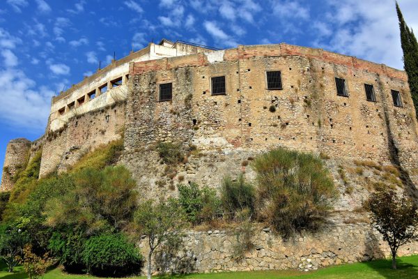
The first stronghold in Ronda – the Castle of Laurel – was built by the Romans in the 3rd century B.C. After the city was conquered by Abbad II al-Mu’tadid in 1065, the Muslims constructed their fortified palace called Alcazaba. It suffered major attacks by Ferdinand II’s troops in 1485 and then by Napoleon’s French army in 1812. Most is now in ruins. Yet the Alcazaba walls along the northeast section of Ronda remain impressive.
Calle Cuesta de las Imágnes, 29400 Ronda, Spain Enlarge/Slideshow See On Map Directions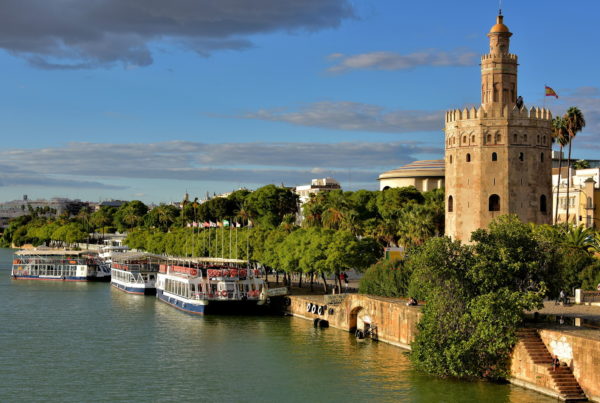
In 1220, Abu Eola, the governor of the occupying al-Andalus, ordered the construction of this watchtower as part of the city walls. To further protect Sevilla from invasion, a chain was stretched across the Guadalquivir River to La Torre del Oro, thus blocking entry by enemy ships. Since 1936, the Tower of Gold has been Museo Naval. The museum has a modest collection of maritime items ranging from the Spanish navigators to military and industrial shipping.
Paseo de Cristóbal Colón, s/n, 41001 Sevilla, Spain Enlarge/Slideshow See On Map Directions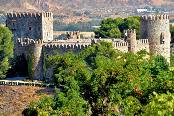
Evidence suggests there was a monastery on this land adjacent to the Tagus River dating back to the 7th century. The current Castle of San Servando was founded in 1085 by Alfonso VI, King of León and Castile. The Brave then donated it to the Order of Saint Benedict. From the early 13th through early 14th centuries, the Knights Templar expanded the stronghold to defend Toledo against the Muslims. Castillo de San Servando was abandoned in 1312 when the Templars – a powerful Christian military order – was dissolved by Pope Clement V.
Cuesta de San Servando, 45006 Toledo, Spain Enlarge/Slideshow See On Map Directions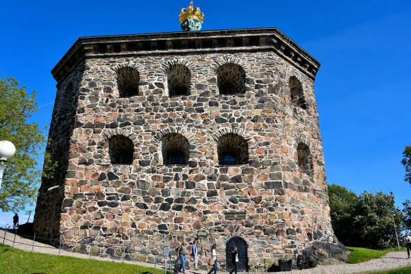
Part of Gothenburg’s defense against the Danes in the late 17th century was the construction of two fortifications called redoubts. The stationed soldiers could easily defend themselves with over 20 cannons. Skansen Kronan means Crown Keep. The fort has six-sided, 15 foot walls made from granite with a gilded cross at the pinnacle. The fortress is perched high on Risåsberget Hill overlooking Skansberget Park and the city below. Not a single shot was ever fired during battle. Today, Skansen Kronan houses a museum and serves as a special event center for weddings and meetings.
Skansen Kronan Risåsberget, 413 04 Göteborg, Sweden Enlarge/Slideshow See On Map Directions
The Kärnan is all that remains of the original Helsingborg Castle that was built by King Eric VI of Denmark at the start of the 14th century. The fortress held a strategic position to protect the narrow strait of the Øresund sound. The citadel exchanged hands several times between Denmark and Sweden until most of the castle was demolished during the late 17th century. Yet this 115 foot tower has stood proudly for over 700 years.
Kärnan Slottshagsgatan, 250 07 Helsingborg, Sweden Enlarge/Slideshow See On Map Directions
Malmö’s first castle was built in 1434. In 1537, King Christian III of Denmark constructed this Renaissance fortress called Malmöhus. The citadel served Danish kings until Sweden’s independence in 1658. Then, it became a defense against the Danes. From 1828 to 1909 it was a prison. Since 1937, Malmöhus has been the home of the Malmö Museum except for a short period in 1945 when it sheltered survivors of German concentration camps. The museum has a collection of art, city history, natural history and maritime exhibits.
Malmöhusvägen 6, 211 18 Malmö, Sweden Enlarge/Slideshow See On Map Directions
Located at the top of a hill on Kastellholmen islet is a classic red brick fortress called The Citadel. When Kastellet was built in 1848, the fort had nine cannons to help defend Stockholm against enemy ships. During World War II, it was fitted with anti-aircraft guns. By 1959, The Citadel was decommissioned. In the 1970s, the former military building was converted into offices. Finally, in 2007, this became the home of the Naval Officers’ Society.
Kastellet Stockholm Kastellbacken 1, 111 49 Stockholm, Sweden Enlarge/Slideshow See On Map Directions
This castle in Nyon, Switzerland, was first built in 1272 by Cossonay Prangins who was part of the Cossonay family, nobility from the Canton of Vaud. It has experienced several expansions and renovations over more than 700 years. It is now a history museum that includes an extensive collection of porcelain dating back to the 18th and early 19th centuries.
Nyon Castle Place du Château 5, 1260 Nyon, Switzerland Enlarge/Slideshow See On Map Directions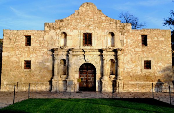
The Alamo in San Antonio, Texas, began as a missionary in 1724 and ended in 1836 as an iconic symbol of courage. During the Texas Revolution, a group of Texians and Tejano Indians won the fort from Mexicans. However, this militia was no match against Santa Anna’s army during a 13 day battle. The fort’s commander, William Travis, wrote in a letter titled Victory or Death, “I shall never surrender or retreat.” Unfortunately, he, Jim Bowie, Davy Crockett and 200 others were killed. Perhaps that is Travis’ shadowy figure on the right still guarding the Alamo.
300 Alamo Plaza, San Antonio, TX 78205 Enlarge/Slideshow See On Map Directions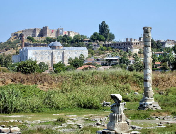
There are four historic landmarks visible from this open field in Selçuk about three miles from Ephesus. Your eyes are immediately attracted to the castle. Archeologists hypothesize people lived on this elevated position since the Bronze Age (over 4,000 years ago). Evidence from the 8th century BC also suggests this was the first location of Ephesus. Ayasuluk Fortress (locally called Ayasuluk Kalesi) originated in the 6th century AD during the Byzantine Era and was abandoned in the 18th century. Also on Ayasuluk Hill is the Basilica of St. John (upper right). The church was built in 565 AD and has been in ruins since the 14th century. Many believe this is the site of John the Apostle’s tomb. He lived in Ephesus while taking care of the Virgin Mary during the last years of her life. On the left is Isa Bey Mosque. The impressive Muslim structure was finished in 1375 during the Ottoman Era by İsa Bey, a member of the Aydınid dynasty. The most famous landmark is the least obvious: the two columns. This is where the Temple of Artemis stood. The first version was built in the Bronze Age and flooded in the 7th century BC. The second iteration was finished about 550 BC. The grand Greek temple was set ablaze in 356 BC by Herostratus, a madman who wanted his name etched in history. The third version began in 323 BC. It resembled the Parthenon but was more than twice the size at 450 by 225 feet. The Temple of Artemis was one of the Seven Wonders of the Ancient World. It was heavily damaged by the Goths in 268 AD and eventually closed in the early 5th century. Scant remnants remain.
Atatürk, Park İçi Yolu No:12, 35920 Selçuk/İzmir, Turkey Enlarge/Slideshow See On Map Directions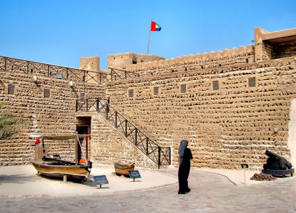
About 25,000 cranes have built exceptional architecture across Dubai’s skyline, including the world’s tallest building and three islands in the shape of a palm. In contrast, the oldest building from 1787 is the Al Fahidi Fort. It is now the Dubai Museum. This woman, who is wearing an Abaya long black robe with a Hijab head scarf, is standing in the fort’s courtyard.
Al Fahidi, 8 58 St - Dubai - United Arab Emirates Enlarge/Slideshow See On Map Directions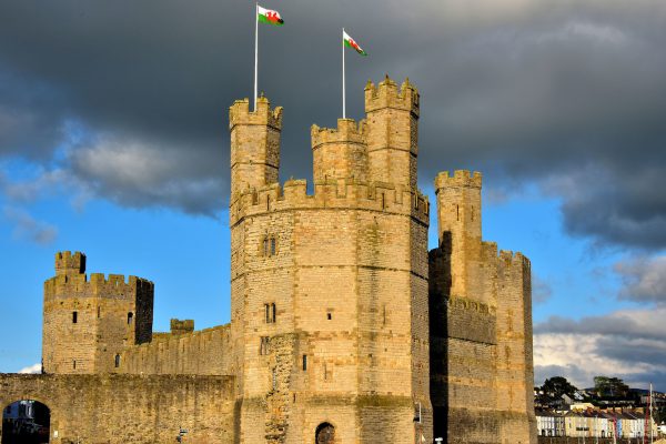
This view of the 13th century Caernarfon Castle from near the Aber Swing Bridge on the south bank of Afon Seiont provides a panorama of the western defenses. Let’s start on the left and look right. The arched opening is Water Gate leading from the quay to Castle Ditch Street. Behind it is the Well Tower. In the foreground is Eagle Tower and next to it is Queen’s Tower. These are three of a dozen towers encircling Caernarfon Castle. This UNESCO World Heritage Site, spelled Caernarvon in English, is one of the most popular tourist attractions in Wales. The warm hue of the façade is courtesy of a wonderful sunset.
Caernarfon Castle Castle Ditch, Caernarfon LL55 2AY, UK Enlarge/Slideshow See On Map Directions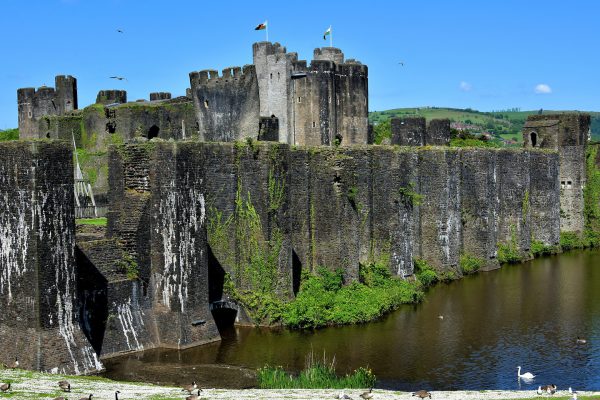
This view from the Outer East Moat displays many of the gorgeous features of Caerphilly Castle. In the foreground is the massive South Dam Platform, a wall of pennant sandstone stretching almost 500 feet. From left to right are: Felton’s Tower, a replica of a siege engine (catapult) between the Great Tower and the Great Hall, the leaning Southeast Tower, the East Inner Gatehouses and the corn Mill.
Caerphilly Castle, Castle St, Caerphilly CF83 1JD, UK Enlarge/Slideshow See On Map Directions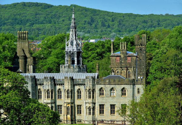
After the Beauchamps, the castle was passed through marriage to the Nevilles in the mid-15th century. When Anne Neville’s husband, King Richard III, was killed by Henry Tudor in 1485, the castle was controlled by his lineage and then Kings Henry VII and VIII until 1551. During the ownership of the Herberts and then the Windors (1551-1776), the castle was frequently besieged and languished in disrepair. Starting in 1776, the Bute family revitalized the castle, especially John Patrick Crichton-Stuart, the 3rd Marquess of Bute. Together with his architect William Burges, they spent 17 years (1865 – 1882) building what some have called a fairytale castle. The centerpiece is this Victorian Gothic façade with elaborately decorated rooms inside. This tour of the Castle Apartments and House will be a highlight of your trip to Cardiff.
West St Cardiff CF10 1BT, UK Enlarge/Slideshow See On Map Directions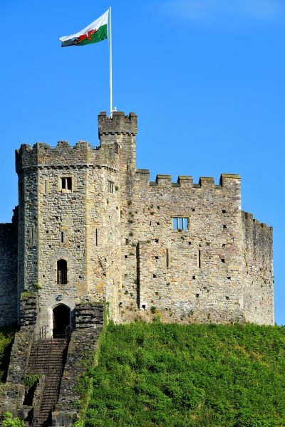
Cardiff Castle began with the Romans who built a fort here during the 1st century. Three more were constructed until they abandoned the ten-acre site in the late 4th century. The Normans arrived in the late 11th century. They initially constructed a wooden keep protected by a high wall and surrounded by a moat. In the 12th century, the Earl of Gloucester built this shell keep (tower) on top of a motte (man-made hill) in the center of an inner bailey (fortified courtyard). The twelve-sided citadel measures 77 feet wide and 30 feet tall. The Normans remained in control until 1216 AD. You can walk up the fifty steps to see the remnants of this medieval keep.
West St Cardiff CF10 1BT, UK Enlarge/Slideshow See On Map Directions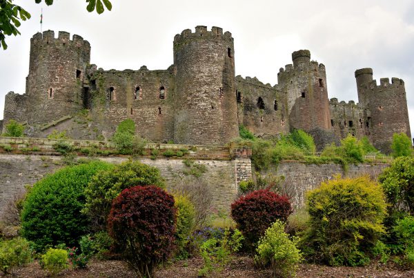
After King Edward I of England suppressed the Welsh in 1283, he demanded their Aberconwy Abbey be moved and this impressive castle be built on its site. Architect John Bonvillars and grand mason James St. George orchestrated hundreds of laborers to complete the Edwardian stronghold within four years. This perspective from across the River Conwy shows the castle’s southern curtain wall. It was constructed from sandstone and limestone. The four towers from left to right are the South-West, Prison, Bakehouse and King’s Towers.
Castle Square, Conwy LL32 8AY, UK Enlarge/Slideshow See On Map Directions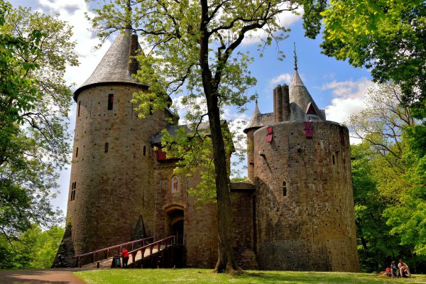
You are convinced this is a beautiful and well-preserved medieval castle while walking towards these three stone towers. Actually, Castell Coch was built in the late 19th century. However, two previous strongholds stood on this site. The first was constructed by the Normans in 1081 as part of their conquest of Wales. Gilbert de Clare, the 7th Earl of Gloucester, built the second in 1277 but it was partially destroyed in 1314. The land was acquired by John Stuart, the 3rd Earl of Bute, in 1760. He was the Prime Minister of Britain and also the first Prime Minister of Scotland. It would be another 100 years before a member of his family, John Patrick Crichton-Stuart, commissioned this castle. The “Red Castle” is located in Tongwynlais, a small town about a fifteen minute drive north of Cardiff.
Castell Coch, Tongwynlais, Cardiff CF15 7JS, UK Enlarge/Slideshow See On Map Directions