It is hard to imagine life as a soldier defending a fort, as a citizen living in a walled-in city or as a king and queen who rules a country from a glorious castle. In this gallery you will see and hear some of those historic stories.
It is hard to imagine life as a soldier defending a fort, as a citizen living in a walled-in city or as a king and queen who rules a country from a glorious castle. In this gallery you will see and hear some of those historic stories.
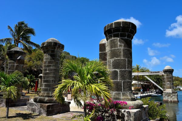
English Harbour began as a British garrison at the turn of the 18th century. For almost two hundred years, it evolved into an elaborate complex of buildings now called Nelson’s Dockyard. The fort was named after Horatio Nelson. The vice-admiral arrived in 1784 and later became its commander. When the Royal Navy base was abandoned in 1889, it fell into disrepair until an extensive restoration was finished in 1961. Nelson’s Dockyard is now a national park and a major tourist attraction. In 2016, this historic property was designated as a UNESCO World Heritage Site. These boat house pillars are among the most recognizable and photographed features.
The Admiral's Inn Dockyard Drive, English Harbour, Antigua and Barbuda Enlarge/Slideshow See On Map Directions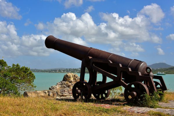
This is one of 10 cannons around Fort James at the northern entrance of St. John’s Harbour. Each of these 2.5 ton cannons could fire a 24 pound ball up to 1.5 miles. The museum-quality guns are rusting away among the ruins of the British fort. Yet these smooth bores still point out to sea as if waiting since 1706 for a battle that never happened.
Fort James, St John's Harbour, Antigua and Barbuda Enlarge/Slideshow See On Map Directions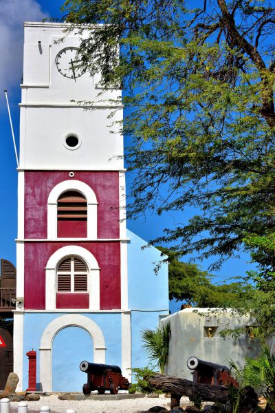
Oranjestad’s oldest building was constructed in 1798 as a Dutch fortress. At its base are two of the original canons. The Willem III Tower, named after the King of the Netherlands (1849-1890), was added to Fort Zoutman in 1868. It functioned as a lighthouse for almost 100 years. After an extensive renovation, the old citadel became the Historical Museum of Aruba in 1984.
Fort Zoutman, Zoutmanstraat 6, Oranjestad, Aruba Enlarge/Slideshow See On Map Directions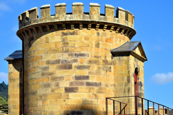
This embattled round tower is in the center of the Military District where Port Arthur’s commandant and officers lived. It is also situated on a hill overlooking the bay and prison yard. While standing on the inner walkway atop its lead roof, a sentry could vigilantly watch for suspicious activity. The cut-stone fortification was ordered by Commandant Charles O’Hara Booth and constructed in 1836 by teenage convicts from Point Puer Boy’s Prison. The Guard Tower was also used as an armory plus had three holding cells for soldiers and “free staff” who committed minor infractions.
6973 Arthur Highway, Port Arthur, TAS 7182, Australia Enlarge/Slideshow See On Map Directions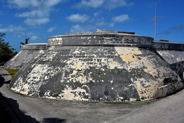
After the Spaniards largely destroyed the Old Fort of Nassau in 1782, British governor Lord Dunmore ordered its replacement in 1789. Fort Charlotte was finished in 1819. This massive stronghold encircled by a dry moat is part of a 100 acre complex consisting of two other forts: Stanley and D’Arcy. Tours are available to learn their history while displaying great views of the western harbor. The stronghold’s namesake is Charlotte of Mecklenburg-Strelitz. She was the wife of King George III of the United Kingdom and the mother of his 15 children. The fort cannons have never been used in battle. However, there is a salute every day at either 11:30 or noon.
W Bay St & Chippingham Rd, Nassau, The Bahamas Enlarge/Slideshow See On Map Directions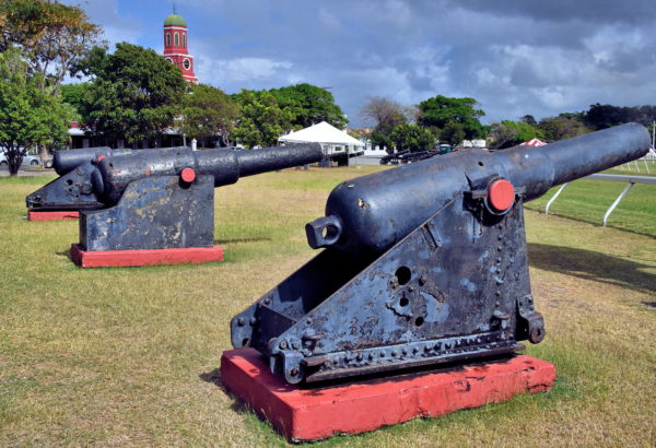
Barbados was heavily fortified during the British colonial period. Two of the strongest defenses were Charles Fort at Needham’s Point (built in 1650) and inland at St. Ann’s Fort (1705) near where you are standing. These 17th and 18th century cannons from the Barbados Garrison are relics of this era. There are 26 of the armaments on display. They point toward the Garrison Savannah Racetrack. Horseracing began here in 1845 when British officers used the parade grounds to wager against each other’s equestrian skills. The horse racing venue has been operated by the Barbados Turf Club since 1905.
Garrison Rd & Hwy 7, Bridgetown, Barbados Enlarge/Slideshow See On Map Directions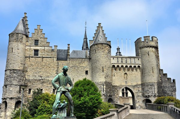
Around 950 AD, Emperor Otto I built a castle along the Scheldt River to defend against Viking attacks. Part of the original structure remains at Het Steen although most of today’s stone fortress was built in the early 13th century. It was later used by Charles V, ruler of the Holy Roman Empire, and then as a prison. It is now a shipping museum. The statue is Lange Wapper, a giant who has been part of local folklore since the 16th century.
Steenplein 1, 2000 Antwerpen, Belgium Enlarge/Slideshow See On Map Directions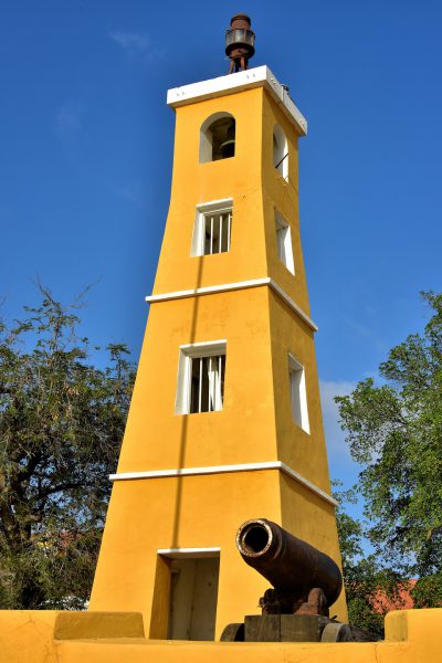
Fort Oranje was built by the Dutch during the 17th century. The fortress was rebuilt almost 200 years later and armed with cannons from a British Navy warship that ran aground off the coast. Those guns were reclaimed by the British a few years later (1807 – 1816) and the four current ones were added. Fort Orange served as the governor’s home until 1837. In 1868, a wooden lighthouse was constructed. It was replaced with this 32 foot, stone version in 1932. This National Monument and Bonaire’s oldest building is now a courthouse. The tower serves as the harbormaster’s office. The fort’s name honors the Netherland’s House of Orange royal family.
Kaya C.E.B. Hellmund & Plaza Wilhelmina, Kralendijk, Caribbean Netherlands Enlarge/Slideshow See On Map Directions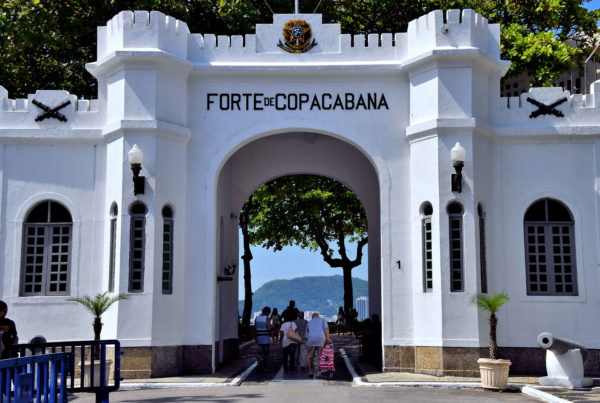
On a headland at the south end of Copacabana is a military base that shares the beach’s name: Fort Copacabana. The Brazilian army constructed the defense in 1914 to help protect Rio’s harbor. This witnessed only one battle. Surprisingly, the conflict came from within. In 1922, a group of officers known as Tenentism staged a rebellion against the republic by firing cannons at key government targets within the city. The 18 of the Copacabana Fort revolt was suppressed within 24 hours. Since the base was deactivated in 1987, Forte de Copacabana has been maintained in great condition.
Praça Coronel Eugênio Franco, 1 Posto 6 - Copacabana, Rio de Janeiro - RJ, 22070-020, Brazil Enlarge/Slideshow See On Map Directions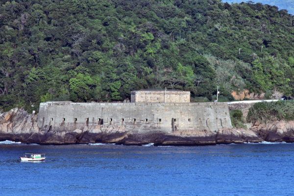
Soon after the city was founded in 1565, the Portuguese began building defenses to protect against sea attacks. One of the earliest batteries – Our Lady of the Guide – was positioned on a promontory at the eastern mouth of Guanabara Bay. This evolved into Santa Cruz da Barra Fortress around 1614. By the end of the 17th century, the port was exporting considerable gold and diamonds. This made Rio an attractive target for French privateers. The fort successfully thwarted an attack by Jean-François Duclerc in 1710 yet failed to repel a similar afront by René Duguay-Trouin the following year. The fort’s complex and firepower was expanded considerably during the 18th century. During the Revolt of the Armada, Fortaleza de Santa Cruz da Barra engaged in its last two battles in 1893 and 1894. Since an extensive restoration, Fortress of Santa Cruz opened for tourism. It is also the Artillery Division for the 1st Army Division.
Fortaleza de Santa Cruz da Barra - Jardim Imbuí, Niterói – RJ, 24370-250, Brazil Enlarge/Slideshow See On Map Directions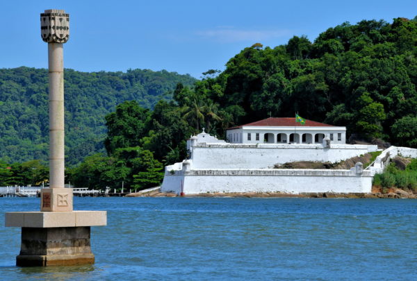
From Ponta da Praia Beach is a specular perspective from across the estuary of Fortress of Santo Amaro of Barra Grande. Barra Grande Fortress was initially built in 1584 to protect the port from attacks by privateers. It was expanded and equipped with new arms several times during the 18th and 19th centuries. The property was also used as a political prison. A boat tour is the best way to reach this historic site. The concrete column is the Marco Padrão de Santos Monument. This marks where Portuguese explorer Martim Afonso de Sousa landed in 1532.
R. Messías Borges - Santa Cruz dos Navegantes, Guarujá - SP, 11425-110, Brazil Enlarge/Slideshow See On Map Directions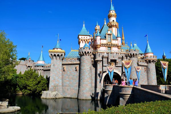
Apparently Walt Disney loved Ludwig II’s Neuschwanstein Castle in Bavaria because the centerpiece of Disneyland when it opened in 1955 was the Sleeping Beauty Castle that shares design elements of the 1892 original. When the animated musical movie “Sleeping Beauty” was released in 1959, it initially was not successful at the box office but after 50 years it is considered to be a Disney classic.
Sleeping Beauty Castle, Main Street U.S.A & Plaza Gardens, Anaheim, CA 92802 Enlarge/Slideshow See On Map Directions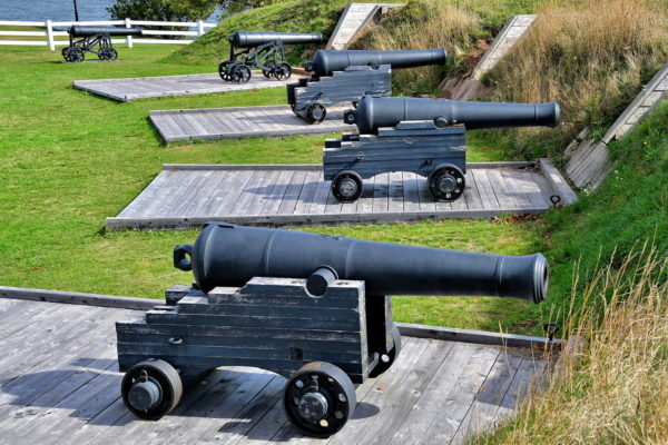
In 1805, the British created a battery on Governor’s Point in anticipation of defending Charlottetown from growing American hostilities. Fire power on the site continued growing until the War of 1812 was concluded. In 1865, the 9-pounder cannons (background) began facing the harbor. The following year, three 32-pounder smooth bore guns on wooden carriages were added. In 1905, Prince Edward Battery at Victoria Park was abandoned. History buffs will enjoy reading the informative plaques about military historic sites on Prince Edward Island from 1776 through 2005.
45 Victoria Park Roadway, Charlottetown, PE C1A 1M6, Canada Enlarge/Slideshow See On Map Directions
The last stop on the southern route of Niagara Parkway is Old Fort Erie. This is a fascinating living history museum. Period-costumed soldiers conduct reenactments and explain the fort’s major role during the War of 1812. Here’s an overview. The British built two supply outposts here at the northeastern tip of Lake Erie during the late 18th century. The current fortification was constructed between 1805 and 1808. This National Historic Site of Canada was a pawn between the Americans and British during the Niagara Campaign. The Americans first overpowered the fort in 1813. A few months later they retreated. On July 3, 1814, the Americans regained control. This set the stage for the bloodiest combat in Canada’s history. During the Siege of Fort Erie (August 3 through September 21, 1814), the Americans successfully defended the fortress against repeated British assaults. Yet the cost was very high. The combined casualties of dead, wounded, captured and missing exceeded 2,500 soldiers. And what was gained? Not much! About six weeks later, the Americans destroyed Fort Erie before returning to Buffalo, New York. On Christmas Eve, the Treaty of Ghent was signed and the War of 1812 was over.
350 Lakeshore Rd, Fort Erie, ON L2A 1B1, Canada Enlarge/Slideshow See On Map Directions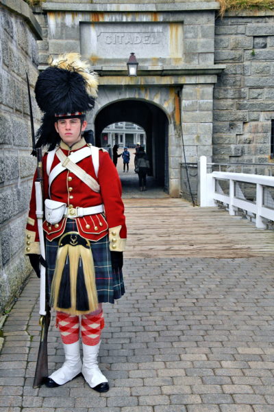
The unquestioned hallmark of the city is the Halifax Citadel. The first fort was commissioned in 1749 by British officer Edward Cornwallis. He was the founder of Halifax while the Governor of Nova Scotia. A replacement was constructed in 1776 in response to the American Revolutionary War. It lasted until the end of the century when a third citadel was finished in 1800. The present-day Halifax Citadel took 28 years to construct (from 1828 until 1856). The star-shaped fort remained in service through the end of World War II. This soldier at the entrance is dressed as a member of the 78th Highland Regiment. They served here from 1869 to 1871. There is a changing of the sentry every hour.
5425 Sackville St, Halifax, NS B3J 3Y3, Canada Enlarge/Slideshow See On Map Directions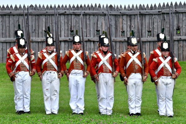
The British soldiers stationed at Fort George during the War of 1812 were from the 41st Regiment. They wore the traditional red coats. This squad marching in formation is one of several reenactments your camera can photograph during your visit at this National Historic Site of Canada. The fortress was built at the end of the 18th century. The name honored King George III of the United Kingdom. It was the headquarters for Major General Isaac Brock before he died at the Battle of Queenston Heights in 1812. The Americans overpowered Fort George in May of 1813 and then abandoned it in December. Afterwards, the British occupied the fortification again until 1815. There are 14 buildings at Fort George for you to explore. All of them were reconstructed during the late 1930s. Only the Powder Magazine is an original structure.
51 Queen's Parade, Niagara-on-the-Lake, ON L0S 1J0, Canada Enlarge/Slideshow See On Map Directions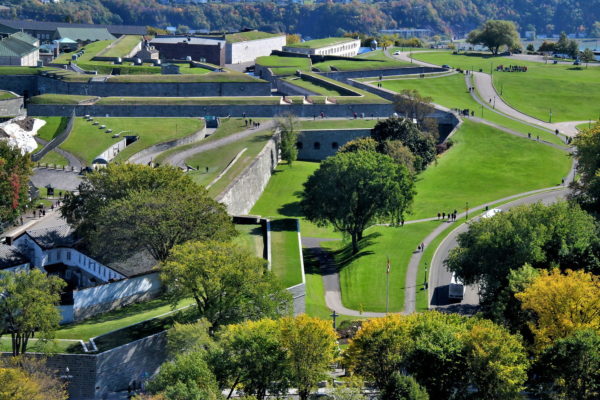
The French built successive Saint-Louis Forts overlooking the Saint Lawrence River in 1620, 1648 and 1723. They also constructed a wall encircling the city in the late 17th century. These defenses proved inadequate against the British during the Seven Years’ War in 1759. After the War of 1812, the British decided to build the existing star-shaped citadel. The fortress was designed by Lieutenant Colonel Elias Walker Durnford. La Citadelle de Québec was finished in 1850. This National Historic Site of Canada consists of 24 structures. One of them is the residence for the governor general of Canada. Others are used by the Royal 22nd Regiment, an infantry battalion of the Canadian Armed Forces. Many of the buildings are open to the public.
1 Côte de la Citadelle, Québec, QC G1R 3R2, Canada Enlarge/Slideshow See On Map Directions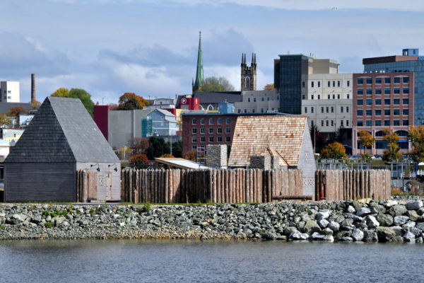
A major historic site you will encounter along the Harbour Passage Trail is Fort La Tour. Originally called Fort Sainte-Marie, this was a fur-trading post established in 1631 by Frenchmen Charles de Saint-Étienne de La Tour. La Tour was a two-time Governor of Acadia. He earned his wealth buying animal pelts from Aboriginal people and selling them to Europeans. This archeological site on Portland Point has been reconstructed as a tourist attraction.
Fort La Tour, 124 Chesley Drive, Saint John, NB E2K 1K7, Canada Enlarge/Slideshow See On Map Directions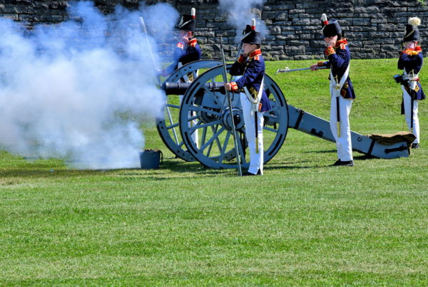
Behind the armoury on the other side of a freeway overpass is Fort York. It was built by the British in 1793. The garrison’s mission was to defend the town of York, the former capital of Upper Canada (today’s Toronto). On April 27, 1813, the fort was attacked and seized by about 1,800 Americans during the Battle of York. The victors then plundered and burned the town before retreating. Fort York continued to house soldiers until the 1930s. The National Historic Site of Canada displays the country’s largest collection of buildings from the War of 1812. They also provide an array of military exhibits and educational programs. Most popular are the demonstrations by the Fort York Guard. These performances include drumming, marching, shooting muskets and firing a cannon. Cover your ears. The cannon blast is very loud.
250 Fort York Blvd, Toronto, ON M5V 3K9, Canada Enlarge/Slideshow See On Map Directions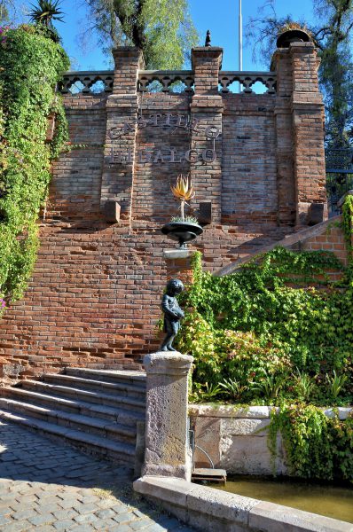
The Spaniards built two forts on top of Cerro Santa Lucia in the early 19th century. After the Spanish were defeated, the citadels were renamed in honor of Argentinean military leaders from the Army of the Andes. This is the entrance to Castillo Hidalgo, a tribute to Captain Manuel Hidalgo. The namesake for the other fortress was Jose Ignacio González. They both died on February 12, 1817, during the Battle of Chacabuco. This was a decisive campaign during the War of Independence of Chile.
Cerro Santa Lucia. Santiago De Chilr Santiago, Región Metropolitana, Chile Enlarge/Slideshow See On Map Directions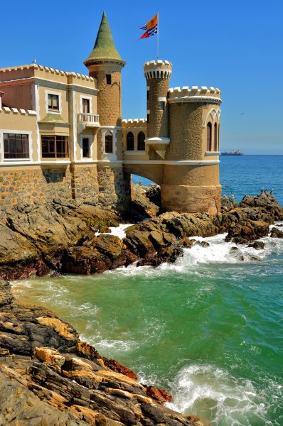
A businessman named Gustavo Wulff proved the famous 1604 quote by Sir Edward Coke that “a man’s home is his castle.” The first phase of El Castillo Wulff was finished in 1908 but it continued to evolve from atop Castle Hill until the middle of the century. This city landmark along the ocean was declared as a National Monument in 1995. Today it houses the Unidad de Patrimonio (the Municipality’s Cultural Heritage Unit) plus an art gallery.
Av. Marina 37, Viña del Mar, Región de Valparaíso, Chile Enlarge/Slideshow See On Map Directions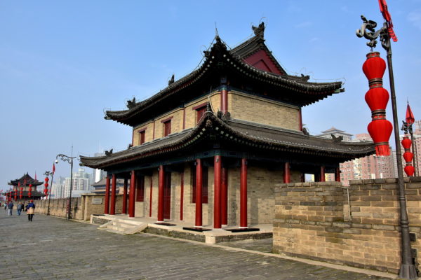
Most of Xi’an’s historic attractions are contained within a fortification dating back to the Ming dynasty (1368 – 1644). Not only is the age impressive but so is the size. The Xi’an City Wall is rectangular and stretches for 8.5 miles. Encircling it is a moat measuring 59 feet across and 20 feet deep. The stone curtainwall is an incredible 50 to 60 feet wide at the base. This upper platform (parapet) averages more than 40 feet across. In short, you are standing on China’s best city wall and also the largest one in the world. These buildings are two of the 98 ramparts atop the wall. They are positioned 390 feet apart. This was the perfect distance for archers to crossfire at the enemy.
Changle Gate, East St, Zhong Lou Shang Quan, Beilin Qu, Xian Shi, Shaanxi Sheng, China Enlarge/Slideshow See On Map Directions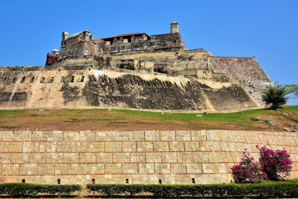
Cartagena’s landmark fort was first built on the Hill of San Lázaro during the early 16th century. When the citadel was significantly expanded in 1657, it was named in honor of Felipe IV. He was the king of Spain from 1621 until 1665. The Castillo has the distinction of being the largest military fortification ever built within the Spanish colonies. It is easy to see how these massive walls repelled an attack by over 23,500 British soldiers in 1741. The Castillo San Felipe de Barajas was declared a UNESCO World Heritage Site in 1984.
Cra. 17 #30-35, Cartagena, Bolívar, Colombia Enlarge/Slideshow See On Map Directions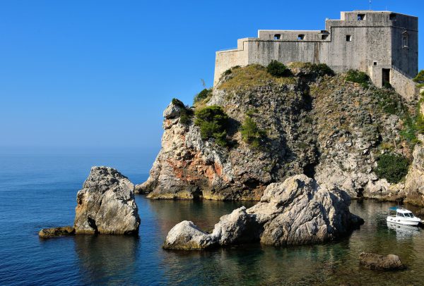
In the early 11th century, the sea-facing, 40 foot thick walls of Fort Lovrijenac were constructed in three months to fend off a pending Venetian attack. Nicknamed “Dubrovnik’s Gibraltar,” St. Lawrence Fortress stands on a 121 foot cliff along Pile Bay near the western edge of Old Town. Above its entrance is an inscription from the Aesop fable “Of Dog and the Wolf.” It says, “Freedom is not sold for all of the gold in the world.” Fans of the HBO series “Game of Thrones” will recognize this as part of King’s Landing, the capital of the Seven Kingdoms.
Ul. od Tabakarije 29, 20000, Dubrovnik, Croatia Enlarge/Slideshow See On Map Directions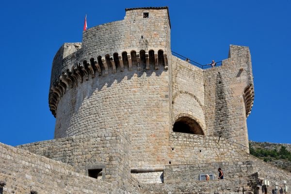
All 8.25 square miles of Dubrovnik’s Old Town is surrounded by walls and forts. They are spectacular! The Minčeta Tower, which was finished in 1464, is the city’s symbol. Tourists flock to climb up this fortress for its spectacular views. Game of Throne fans are thrilled to see what was called the House of the Undying in parts of season two.
Ul. Ispod Minčete 9, 20000, Dubrovnik, Croatia Enlarge/Slideshow See On Map Directions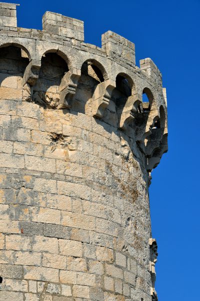
Tower Kanakević was built in 1488 when this town was named Curzola and ruled by the Republic of Venice. It was commissioned by Agostino Barbarigo, the Dodge of Venice who was also responsible for Italy’s most famous clock tower at Piazza San Marco. This fortress is sometimes called Kula Kanalvic. This refers to Petar Kanavelić, a famous and prolific Croatian writer who lived next door during the 17th century.
Šetalište Petra Kanavelića, 20260, Korčula, Croatia Enlarge/Slideshow See On Map Directions
These are two of the twelve towers surrounding the old town of Korčula. The Large Tower of the Governor is massive and circular. Behind Velika Kunaseževa Kula is the slender and cylindrical Small Tower of the Governor. In Croatian it is called Mala Kunaseževa Kula. Both of these fortifications were built during the 15th century to protect the Governor’s Palace.
Obala Franje Tuđmana, 20260, Korčula, Croatia Enlarge/Slideshow See On Map Directions
Split was under the rule of the Republic of Venice from 1420 until 1797. In 1435, the Venetians built a castle near the shoreline outside of the southwestern wall of Diocletian’s Palace. This octagonal tower is all that remains. It is a formidable reminder of the strength of the Venetians from over 200 years ago. Mletačka Kula is located in Braće Radić Square, also called Fruit Square.
Trg Braće Radić 6, 21000, Split, Croatia Enlarge/Slideshow See On Map Directions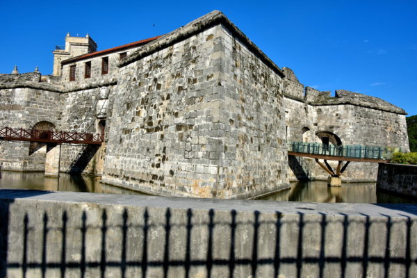
On this spot near the harbor was the oldest bastion fortress in the Americas. In 1558, engineer Bartolomé Sánchez was commissioned to replace it. Then called Fuerza Nueva (New Force), the limestone, star-shaped fortress was finished in 1577 and surrounded by a moat. The castle was the residence of governors, captain generals and their army. During the 20th century, Castillo de la Real Fuerza (Castle of the Royal Force) was repurposed several times. Real Fuerza has housed the National Archive, National Library, Museum of Arms and National Museum of Cuban Ceramics. Since 2010, this historic landmark has been a fascinating maritime museum named Museo de Navegación. Inside are displays and artifacts telling stories of Cuba’s relationship with the sea going back before Columbus.
Castillo de la Real Fuerza, O'Reilly, La Habana, Cuba Enlarge/Slideshow See On Map Directions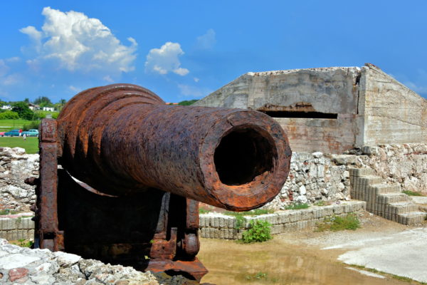
This cannon is rusted and silenced. Yet its location at El Morro Castle is symbolic of 16th century Spanish forts stretching from Florida to the tip of South America. The reign of Philip II – King of Spain from 1556 to 1598 – was the height of the Spanish Golden Age. His vast empire extended across every continent. However, the riches the crown collected from the New World attracted constant attacks from pirates such as Sir Frances Drake. So, in 1586, Felipe II appointed a young engineer named Battista Antonelli to first assess the defenses of strategic Caribbean ports (including Cartagena, Panama, Santo Domingo and Puerto Rico) and then build fortifications. While Antonelli was in Havana during the last half of 1587, he designed El Morro and La Punta. He returned to Cuba briefly in 1589 to initiate El Morro. Then, from 1589 – 1599, Antonelli managed the construction of most of the Spanish forts across the Caribbean.
Parque Histórico Militar Morro-Cabaña, La Habana, Cuba Enlarge/Slideshow See On Map Directions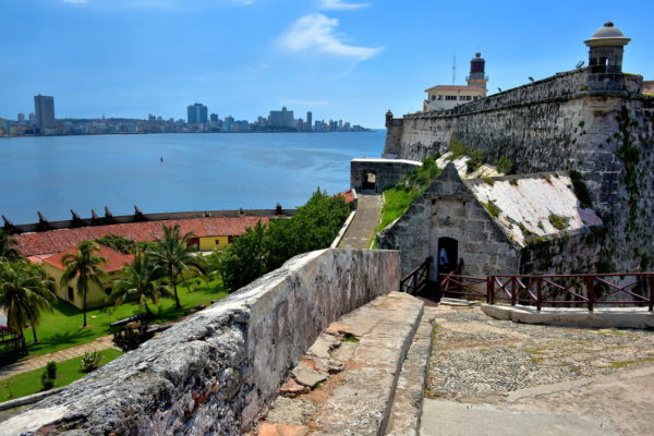
The British occupation of Havana did not last long after their victory in 1762. The Seven Years’ War concluded with the signing of the Treaty of Paris in February, 1763. Part of the global land exchanged brokered in the agreement was Cuba was returned to the Spanish in exchange for Florida. King Charles III of Spain was then determined to enhance the defense of Havana. He ordered an additional fort adjacent to El Morro. By the time Fortaleza de San Carlos de la Cabaña (Fort of Saint Charles) was finished along the eastern side of the harbor in 1774, the wall stretched nearly 2,300 feet. This was the largest Spanish fort in the Americas. La Cabaña now hosts three museums: The Command Headquarters of Che Cuevara, the Museum of Arms and a fort history museum.
La Cabaña, La Habana, Cuba Enlarge/Slideshow See On Map Directions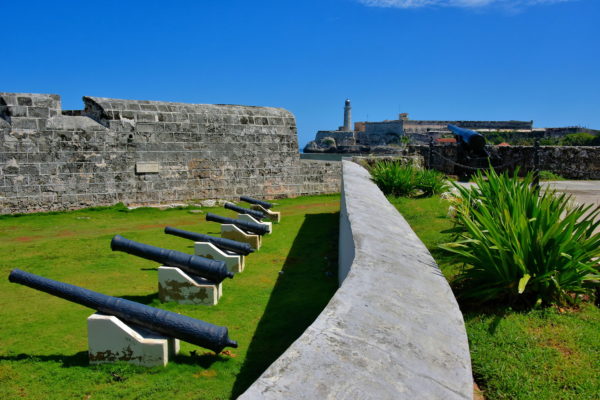
Notice how Castillo de San Salvador de la Punta is directly across the water from El Morro and its lighthouse. Beginning in 1630, an 820 foot boom chain was strung between the two forts to prevent enemy ships from entering the harbor. This proximity was also the demise of the La Punta. In 1762, during the Battle of Havana, the British first captured El Morro. Then they used this strategic position to unleash over 50 cannons at La Punta. The meager Cuban battery of 19 smoothbores was no match. Castillo de San Salvador de la Punta surrendered in a single day. Today, this short distance is your advantage. You can travel from here to El Morro Castle via an underwater tunnel called Tunel de La Habana.
Malecón and Paseo de Martí Streets, La Habana, Cuba Enlarge/Slideshow See On Map Directions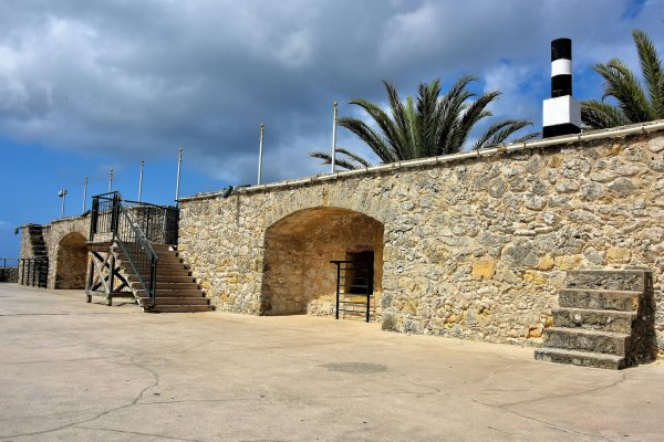
The first level of Rif Fort is now the Renaissance Mall filled with upscale stores, restaurants, entertainment venues plus a museum that opened in 2014. History buffs will enjoy the second level. You will see part of the defensive walls dating back to the early 19th century. They were constructed with coral and reach a width of almost five feet. Notice the batteries. They were used to position and fire some of the Riffort’s 56 cannons. When you climb those wooden stairs you will be rewarded with an amazing view of the Caribbean Sea.
507 Pater Euwensweg, Willemstad, Curaçao Enlarge/Slideshow See On Map Directions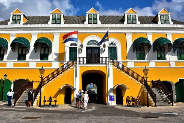
Shortly after the Netherlands overthrew the Spanish in 1634, the Dutch West India Company began building a fortress on the eastern shore of the Sint Anna Bay. Fort Amsterdam saw military action by the British in 1804 and fell to Venezuelan soldiers in 1929. Notice the two cannons in the inner courtyard that once protected the city. This beautiful old citadel now serves as the home of the island’s governor plus contains other government offices.
Governor's Palace Gouvernementsplein, Willemstad, Curaçao Enlarge/Slideshow See On Map Directions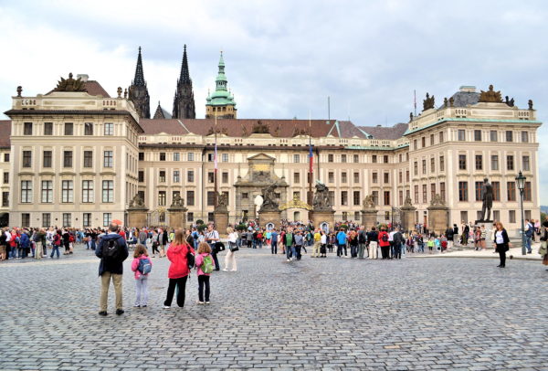
In the Hradčany district is the world’s largest castle. It measures 1,870 feet long. The interior is an incredible 750,000 square feet. Prague Castle began in the late 9th century while Bořivoj I was the Duke of Bohemia from 867 until 889. It was extended several times over the centuries. Major expansions were commissioned by King Ottokar II of Bohemia (13th century), Holy Roman Emperor Charles IV (14th century), Vladislaus II of Hungary (1471 – 1516), Holy Roman Emperor Ferdinand I (16th century) and Empress Maria Theresa (mid-18th century). Prague Castle was partially destroyed during the Hussite Wars (early 15th century), a fire in 1541, the Second Defenestration of Prague and the subsequent Thirty Years Wars (first half of 17th century) plus the War of the Australian Succession (mid-18th century). The castle was also occupied by the Germans during World War II and the Communist Party of Czechoslovakia after the coup d’état in 1948. The Czech Republic was formed in 1993 when Václav Havel became the first president. This is the castle’s First Courtyard, built in 1765.
První nádvoří Pražského hradu, 118 00 Praha 1-Hradčany, Czechia Enlarge/Slideshow See On Map Directions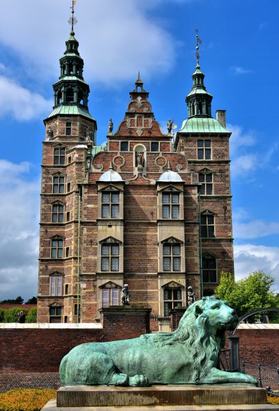
Several major architectural projects were commissioned in Copenhagen during the 17th century. Most were designed in the Dutch Renaissance style. A classic example is the Rosenborg Castle built in 1624. The slot served as a royal residence from 1624 until 1710 plus two other short times during Copenhagen’s history. The Resting Lion, which pre-dates 1673, is one of two matching sculptures. They protect a small pedestrian bridge leading from The King’s Garden.
Øster Voldgade 4A, 1350 København, Denmark Enlarge/Slideshow See On Map Directions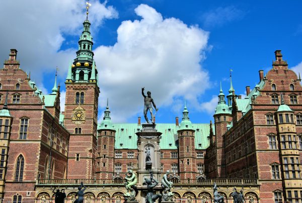
It is a delightful challenge for your eyes to drink in all of the magnificent details of the Frederiksborg Castle. The slot’s red brick façade is adorned with a clock tower, copper-crowned spires plus mythological and Renaissance sculptures. In the foreground is a reproduction of the Neptune Fountain. The original was installed in 1620 but then seized by Swedish soldiers in 1659 during the Second Northern War. Jacob Christian Jacobsen, the founder of Carlsberg brewery, paid for the fountain to be recreated in 1888.
Frederiksborg Slot 10, 3400 Hillerød, Denmark Enlarge/Slideshow See On Map Directions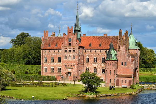
During the mid-16th century, Denmark was plagued by civil wars plus political and religious upheaval. Therefore, it was common for Dutch noblemen like Frands Brockenhuus to build a fortress to defend their estate and family from attacks. The design of the Egeskov Slot included a wide moat, three foot walls, battlements, arrow slits plus machicolations for dropping stones or scalding oil from the towers onto attackers below.
Gade 18, 5772 Kværndrup, Denmark Enlarge/Slideshow See On Map Directions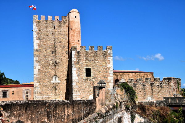
Fray Nicolás de Ovando had valid reasons to believe Santo Domingo was vulnerable to attack when he became governor in 1502. The riches from the gold rush of 1500 to 1508 had attracted the attention of potential French and British conquerors plus pirates. The enslaved Indigenous Taíno people were increasingly combative as their population shrank from disease and abuse while working the mines. So he ordered the construction of Ozama Fortress. The initial citadel was finished in 1508. The 59 foot Tower of Homage was added in 1509. Torre del Homenaje became the temporary residence of Diego Columbus (eldest son of Christopher) when he was appointed Governor of the Indies in the same year. Throughout most of the ensuing 500 years, Ozama Fortress was a prison. Many political adversaries were incarcerated and executed here until the 1960s.
Calle Las Damas 1, Santo Domingo 10210, Dominican Republic Enlarge/Slideshow See On Map Directions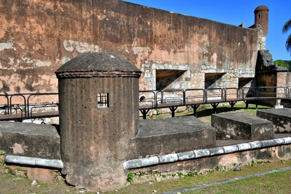
Now look to your left. This is the Low Battery of San Diego (Bateria Baja de San Diego). Imagine being a 16th century invader and staring at the cannons protruding from the flared openings called embrasures. Equally daunting was another set of guns positioned above. If you have time, you can continue exploring the defensive wall in either direction. Heading south brings you to a bastion called Invincible Fort (Fuerte Invencible). This is across from the Don Diego cruise and ferry terminal.
Puerta de San Diego, Av Francisco Alberto Caamaño Deñó, Santo Domingo 10212, Dominican Republic Enlarge/Slideshow See On Map Directions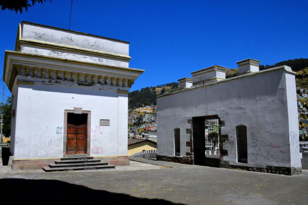
Defining the southeastern border of Historic Quito is a 9,895 foot mount. The Incas called it Shungoloma. After the fall of their empire in 1533, the Spaniards renamed it El Panecillo because it resembles a small loaf of bread. The conquerors quickly recognized the strategic value of this elevation. They built a fort with cannons pointing in every direction. In 1812, this Spanish defense was stormed and seized by rebels during the Ecuadorian War of Independence. The success was short lived. Within weeks, the Spanish recaptured the hill and resumed control over the city. A clash a decade later had a different outcome. During the Battle of Pichincha in 1822, the patriots defeated the Spanish and won Quito’s freedom. These are the sparse ruins of the former Spanish fort.
Agoyán y Rio Verde, El Panecillo, Quito 170111, Ecuador Enlarge/Slideshow See On Map Directions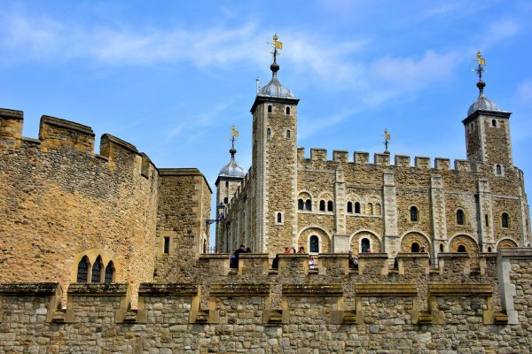
In a city filled with historic landmarks, the Tower of London is among its most famous. On the right is the White Tower. This 89 foot tall, central keep was ordered by William the Conqueror. Construction of the Norman castle using Caen Stone and Kentish Ragstone began around 1078. The first phase of the donjon was finished at the end of the century. After Henry III ordered it to be whitewashed in 1240, it became known as the White Tower. Over the millenniums, additional buildings were added to the 12-acre royal residence. An example is the Beauchamp Tower on the left. King Edward I ordered architect Master James of St George to build it in the late 13th century. Within its walls were numerous famous prisoners including Anne Boleyn – the second wife of Henry VIII – and Lady Jane Grey. Both queens were beheaded for treason during the first half of the 16th century. In the foreground are the casements. This tall curtainwall forming the outer ward is surrounded by a moat.
1 Tower Hill Terrace, London EC3N 4EE, UK Enlarge/Slideshow See On Map Directions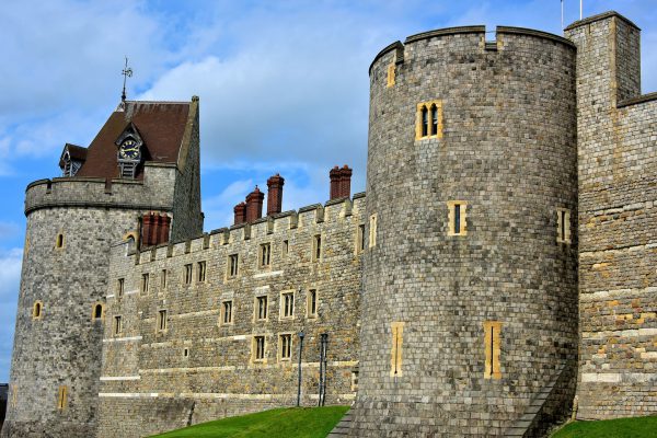
Windsor Castle is a must-do day trip while visiting England. The 13-acre royal estate is about a half-hour train ride from London and then a short walk from Windsor Central Station. Your first glimpse is the western curtain wall constructed during the mid-13th century by King Henry III. This defense stands 100 feet and is 13 feet thick. On the left is Curfew Tower, a former medieval dungeon, built circa 1230. The belfry was originally part of the College of St. George and moved here in 1478. The clock was replaced in 1689. All of these features were restored in 1863. On the right is the Garter Tower. Its namesake is the knights of the Order of the Garter. Now hurry along. You haven’t come to the best parts yet.
Windsor SL4 1NJ, UK Enlarge/Slideshow See On Map Directions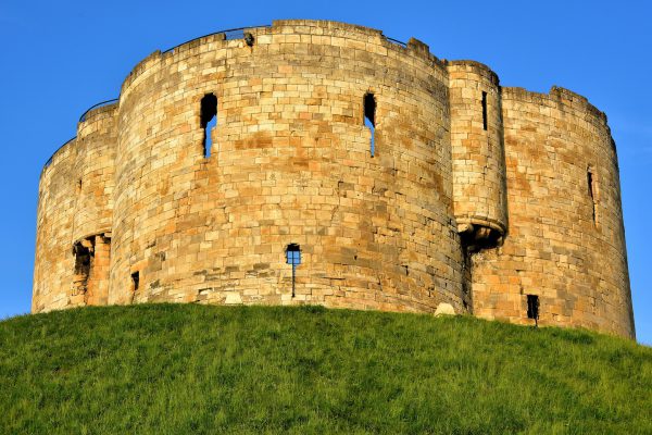
Two years after William the Conqueror became the first Norman king of England in 1066, he commissioned a wooden, motte-and-bailey castle be built in York. Within a year it was destroyed by the Vikings. Not to be deterred, William I had it rebuilt with greater fortifications including a moat. When King Henry III reconstructed it again during his reign from 1216 through 1272, this limestone keep was added. Master Mason Henry de Rayns gave it a unique design with four semi-circles called quatrefoil. It was originally called King’s Tower. It was renamed as a tribute to Henry Clifford, 5th Earl of Cumberland. His Royalist forces defeated the Parliamentarians here in 1643 while defending the throne of King Charles I. This medieval landmark atop a motte in center city is one of the few structures remaining of York Castle.
3 Tower St, York YO1 9RZ, UK Enlarge/Slideshow See On Map Directions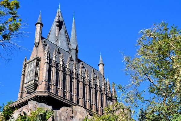
Any fan of Harry Potter will immediately recognize this castle, home of the Hogwarts School of Witchcraft and Wizardry. Inside is one of the best theme park rides in the world: Harry Potter and the Forbidden Journey. But before you are strapped in, you’ll see rooms you recognize like the Headmaster’s office. Plus there is plenty of magic like the Mirror of Erised and talking portraits. You’ll be reminded of Professor Dumbledore’s quote, “Of course it is happening inside your head, Harry, but why on earth should that mean it is not real.”
Hogwarts Castle, Orlando, FL 32819 Enlarge/Slideshow See On Map Directions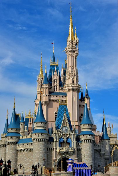
Cinderella Castle is the Magic Kingdom’s most iconic building. Its Romanesque Revival design is modeled after the Neuschwanstein Castle in Bavaria, Germany. That famous schloss was built for Ludwig II in 1886. Author Charles Perrault’s late 17th century tale “Cendrillon” (or “The Little Glass Slipper”) laid the groundwork for Disney’s 1950 animated film “Cinderella.” The folktale is about a young girl who suffers forced servitude by her stepfamily until rescued by a handsome prince.
Castle Stage, Fantasyland, Lake Buena Vista, FL 32830 Enlarge/Slideshow See On Map Directions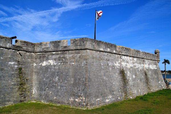
This fortress was in military service for over 250 years. When built by the Spaniards in 1696, they named it Castillo de San Marcos. The walls were constructed with coquina. This is a mix of seashells and limestone. Encircling the citadel was a moat with seawater from Matanzas Bay. The British called it Fort St. Mark during their occupation from 1763-1783. When the U.S. took control in 1821, the Army base became Fort Marion. It was finally deactivated in 1933. Castillo de San Marcos is now a National Monument managed by the National Park Service.
1 S Castillo Dr, St. Augustine, FL 32084 Enlarge/Slideshow See On Map Directions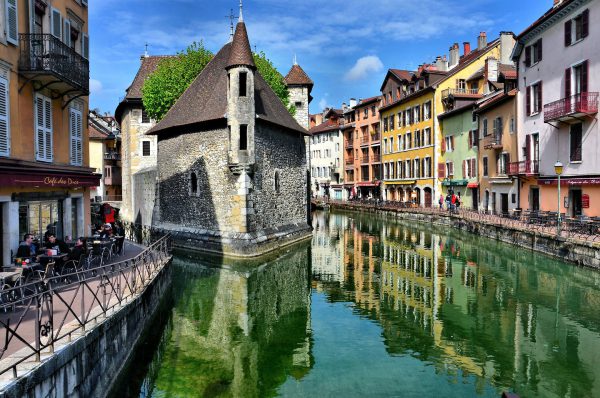
Sitting regally on a triangular island in the Thiou Canal is an equally triangular castle with thick stone walls resembling the bow of a ship. Apparently, after some of the major Parisian landmarks, the Palais de I’Isle in Annecy is one of the most photographed buildings in France.
Le Palais de I'lle 3 Passage de l'Île, 74000 Annecy, France Enlarge/Slideshow See On Map Directions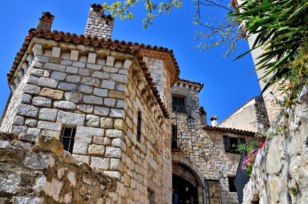
People started living on the hill now known as Éze Village over 4,000 years ago. For centuries, it was attacked and claimed by several countries. Finally, in 1706, the army of King Louis XIV of France conquered it for the last time. You sense the history as you walk along the crooked and sloped alleys defined by fortified walls and stone buildings.
16-18 Rue Principale,06360 Èze, France Enlarge/Slideshow See On Map Directions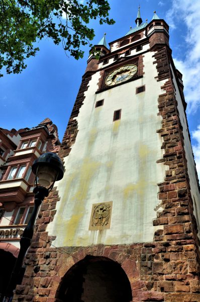
In German, the word “burg” means fortified town and the Martinstor is one of two gates that protected Freiburg im Breisgau during medieval times. When it was built around 1238, it was called Porta Sancti Martini which translates into the Latin Gate of the Holy Martin. The tower stands almost 200 feet tall and the arch below still acts as an entry into the old town.
Kaiser-Joseph-Straße 233, 79098 Freiburg im Breisgau, Germany Enlarge/Slideshow See On Map Directions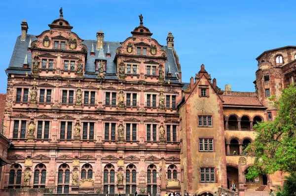
On top of the Friedrichsbau, which was built in the early 17th century by its namesake Elector Friedrich IV, is a sandstone sculpture of Lady Justice and in the niches across the façade are the generations of Palatine Prince Electors of the Rhine who ruled the Kingdom of Germany from 915 until 1803.
Schlosshof 1a, 69117 Heidelberg, Germany Enlarge/Slideshow See On Map Directions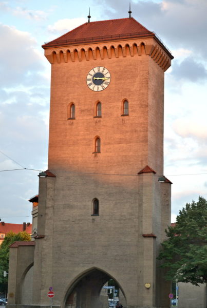
During the Middle Ages, European cities were commonly encircled by high walls. Munich was no exception. The first wall was constructed in 1175 by Henry the Lion, Duke of Bavaria (1156 to 1180). When the defense became inadequate, new walls were built from 1285 through 1347. They were significantly fortified during the early 17th century. By the 18th century, the walls had outlived their value and were torn down. Fortunately, three of the original eight tors (German for gates) were spared. One of them is Isar, named after the river. Isartor was built in 1337 and has been restored a couple of times. The orange glow on the central tower of Isartor is courtesy of the setting sun.
Tal 50, 80331 München, Germany Enlarge/Slideshow See On Map Directions