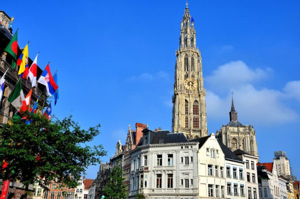
The Old Town of Antwerpen in northern Belgium is charismatic. On the left is the colorful City Hall called Stadhuis. In the middle is the Cathedral of Our Lady clock spire. Antwerpen is famous as the “diamond capital of the world.” 20,000 of the city’s half million residents also work in fashion. Antwerp has developed an excellent reputation in this industry since the mid-1990s.
Grote Markt 4, 2000 Antwerpen, Belgium Enlarge/Slideshow See On Map Directions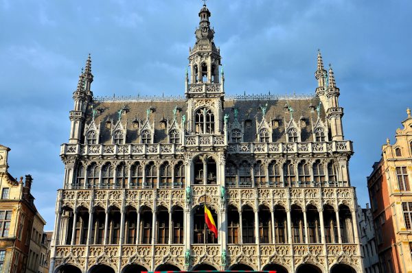
If you are interested in history, you will want to walk through the Museum of the City of Brussels. It is housed in Maison du Roi. The building is also known as King’s House. The impressive structure was built in 1536 by the Duke of Brabant. Another name is the Breadhouse because it was the bread market from the 13th through the early 16th centuries. Maison du Roi is located on the north side of Grand Place. This has been the city’s major square since the late 11th century when it was called the Lower Market.
Grand Place 29, 1000 Bruxelles, Belgium Enlarge/Slideshow See On Map Directions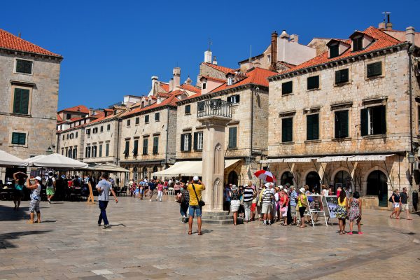
From 1102 until 1526, Dubrovnik was part of the Kingdom of Croatia in union with Hungary. Symbolic of this protective arrangement was a legendary knight named Orlando (also called Rolando). A larger than life sculpture of the hero stands on this column bearing his name in Luža Square. It was sculpted in 1418. During the Middle Ages and the Renaissance, the platform on top was used by orators for proclamations. The square was the venue for public punishments.
Luža ulica, 20000, Dubrovnik, Croatia Enlarge/Slideshow See On Map Directions
The Old Town of Korčula was a walled-in peninsula surrounded with massive stone walls and a network of medieval towers in the 13th century. They were maintained until the end of the Venetian Republic in 1797 when Korčula became part of the Habsburg Monarchy. After centuries of neglect, most of the walls were torn down during the 19th century. One of the few that remains is this rampart attached to the Veliki Revelin Tower. Veliki in Croatian means great or big.
Ul. Korčulanskog statuta 1214, 20260, Korčula, Croatia Enlarge/Slideshow See On Map Directions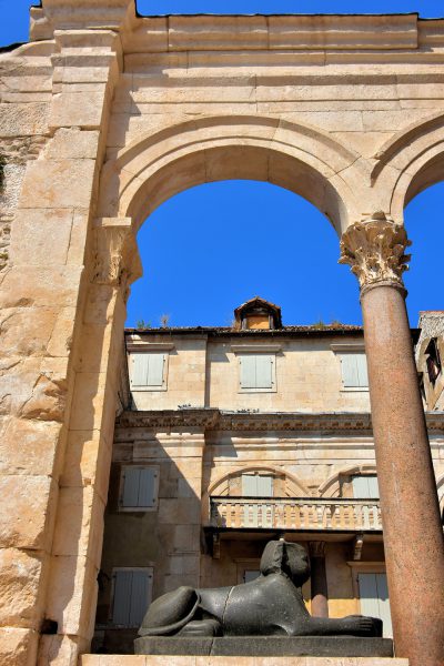
This sphinx is often overlooked by most tourists because it is positioned next to the Cathedral of Saint Domnius and the Peristyle of Diocletian’s Palace. But don’t miss it. This treasure from Luxor, Egypt is one of three sphinxes in Split from the reign of Pharaoh Thutmose III. He ruled Egypt for almost 54 years. When he died in 1425 BC, he was buried in the Valley of the Kings.
Peristil ul. 3, 21000, Split, Croatia Enlarge/Slideshow See On Map Directions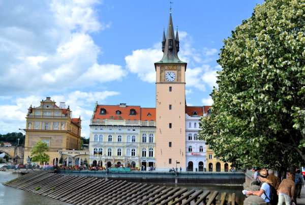
A delightful street in Old Town for a picturesque walk is Smetanovo nábřeží. The Smetana embankment is named after 19th century Czech composer Bedřich Smetana. This short riverside esplanade stretches from Legion Bridge to Charles Bridge (Most legií to Karlův most). Along the way you will enjoy panoramic views of Malá Strana (Lesser Town) and Hradčany (Castle District) across the Vltava river. Anchoring this right bank is the Old Town Waterworks and Tower on the Novotny bridge (Novotny Lávka). Clustered around it are former mills. Are you hungry after your stroll on the Smetana waterfront? A few steps away is the Bellevue (means beautiful sight). The restaurant’s excellent cuisine with stunning scenery makes it one of the best places to eat in Prague.
Smetanovo nábř. 329/18, 110 00 Praha-Staré Město, Czechia Enlarge/Slideshow See On Map Directions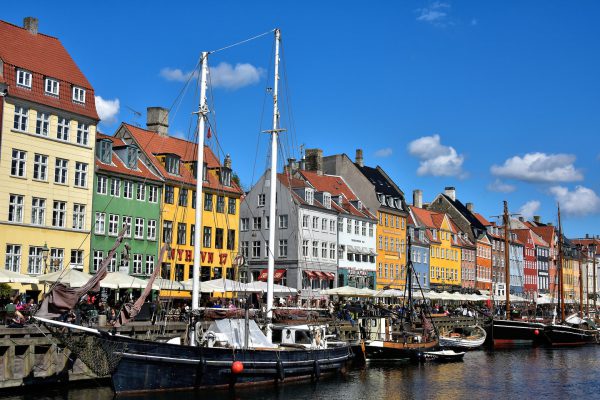
These ships are moored at the quay on Nyhaven. The docked vessels continue a tradition dating back to 1673 when this inner harbor was dug out by prisoners at the command of King Christian V. For the next 400 years, it grew into a major shipping port but then tapered off in the late 1940s. Today, traffic consists of some working vessels, restored wooden sailing ships plus sightseeing boats.
Nyhavn 2, 1051 København, Denmark Enlarge/Slideshow See On Map Directions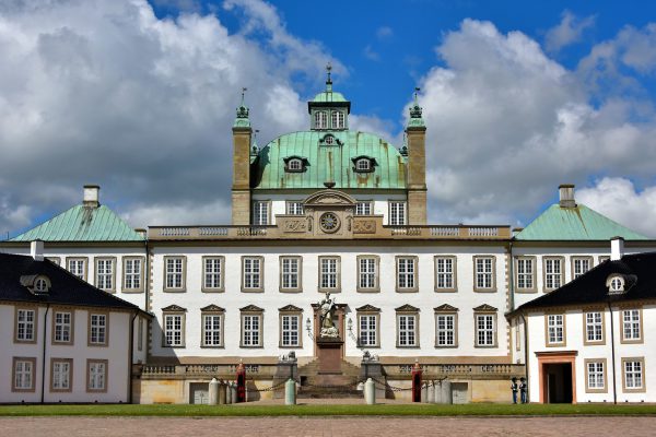
Denmark is blessed with several palaces and castles. Most are far more elaborate than the Fredensborg Palace. Yet, this seasonal royal residence can best be described as elegant. Many call it the Danish Versailles. The 89 foot dome is flanked by four copper-roofed pavilions. Stretching between them is a sandstone balustrade with a clock in the middle. The statue in the courtyard is only a hint of the 70 life-sized sculptures adorning the beautiful garden in back. Tours of the palace are only available in July but the garden is free to visit all year.
Slottet 1B, 3480 Fredensborg, Denmark Enlarge/Slideshow See On Map Directions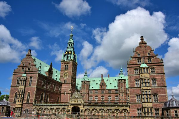
Christian IV was the oldest son of Frederick II. He was born in Frederiksborg in 1577, assumed the throne when he was 11 years old and was crowned eight years later. His rule lasted 59 years, from 1588 until 1648. This is the longest reign in Denmark’s history. While the king of Denmark and Norway, Christian Firtal not only built this magnificent Frederiksborg Castle but also several other grand structures in Denmark. His dream was to make the country an international trading center and a superpower with a dominant navy and army. Although he is credited with sweeping reforms and a growing prosperity, his aspirations eventually led to overspending, several wars and economic decline.
Frederiksborg Slot 10, 3400 Hillerød, Denmark Enlarge/Slideshow See On Map Directions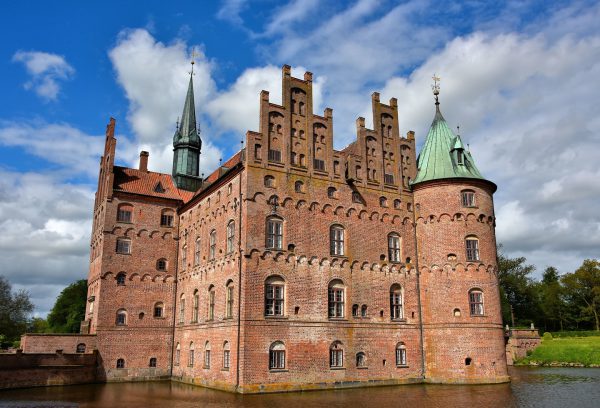
A family estate at Kværndrup, Denmark dates back to 1405. Starting in 1524, Frands Brockenhuus and his wife Anne Tinhuus spent thirty years building the Egeskov Castle on property owned by her parents. In 1784, it was purchased by Henrik Bille. Amazingly, his descendants have lived here for over 230 years. Although much of the surrounding property is now a tourist attraction, the castle has been the home of Michael and Caroline Ahlefeldt-Laurvig-Bille since 1994.
Gade 18, 5772 Kværndrup, Denmark Enlarge/Slideshow See On Map Directions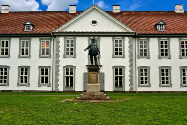
This section of Odense Palace was built in 1723. Yet the history of the property is much older. Portions of Odense Slot date back to the 15th century when it was a monastery run by the Knights of St. John monks. It was confiscated by the king in the early 16th century. As the centuries passed and politics changed, it had several successive occupants. They included Swedish troops, the head of Funen County and King Frederik IV of Denmark who commissioned this addition. Later tenants were a French general, the governor of Funen and then a museum. Today, this Dutch Baroque palace houses administrative offices of the Odense Municipality.
Odense Slot 5000 Odense, Denmark Enlarge/Slideshow See On Map Directions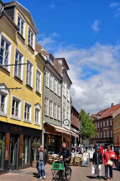
The street named Gerritsgade is in the historic core of Svendborg. It was first mentioned in 1552, making it one of the town’s oldest streets. On either side of the cobblestones are shops ranging from the luxury jewelry store Phigo to small specialty boutiques. You will also find taverns and excellent restaurants.
Gerritsgade 50, 5700 Svendborg, Denmark Enlarge/Slideshow See On Map Directions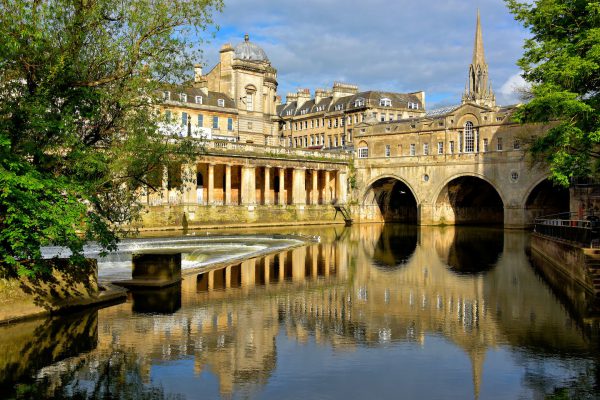
The River Avon, also called the Bristol Avon, flows for 75 miles and cradles the east and south edges of Bath’s old town. This is the visual apex. On the right is the Pulteney Bridge, named after its investor Sir William Pulteney. The very wealthy 5th Baronet commissioned architect Robert Adam to build this arched span in 1769 so he could easily reach the city from his Bathwick Estate across the river. The 148 foot length is lined with shops. On the left is a three-level, crescent-shaped sluice gate. The current Pulteney Weir became operational in 1972. Yet, Bath had two water-powered mills dating back to the early 1600s. From this vantage point you can also appreciate the Newmarket Row (left), Victoria Art Gallery and the tower of St Michael’s Without (right).
Beazer Maze Spring Gardens Rd, Bath BA2 6PW, UK Enlarge/Slideshow See On Map Directions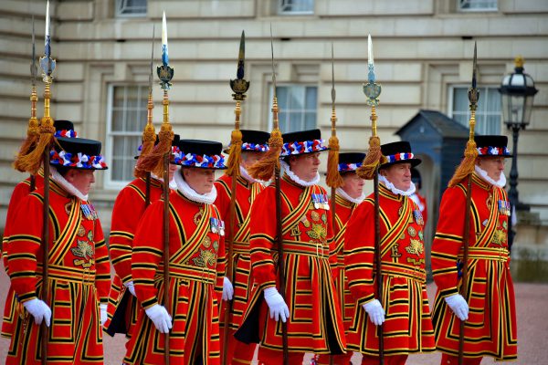
Yeoman Warders were established in 1485 by King Henry VIII to protect the Tower of London. Over the centuries, their role evolved until now they are ceremonial guards at the Her Majesty’s Royal Palace plus tour guides at the Tower of London. Today, they number 36 men and one woman. In order to qualify, they must be retired from the Armed Forces as non-commissioned officers and served for at least 22 years. These Beefeaters are wearing the red and gold Tudor State Dress uniform reserved for formal state events. The occasion on this day was one of the three summer gala garden parties hosted by Queen Elizabeth at Buckingham Palace.
Buckingham Palace, London SW1A 1AA, UK Enlarge/Slideshow See On Map Directions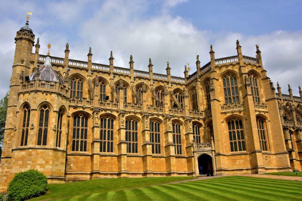
The first Chapel of St. George was built within Windsor Castle by King Edward I during the 13th century. Unsatisfied with his grandfather’s efforts, King Edward III had the chapel rebuilt in the Lower Ward circa 1337. However, it was Edward IV who started the present building in 1475 during his second reign as England’s king. The Royal Chapel was not completed until 1528 during the rule of Henry VIII. Several monarchs and their queens plus princes and princesses are buried here. The chapel’s namesake is Saint George. He was a Roman soldier who was executed in 303 for not recanting his Christian beliefs. He is also England’s patron saint.
3 The Cloisters, Windsor SL4 1NJ, UK Enlarge/Slideshow See On Map Directions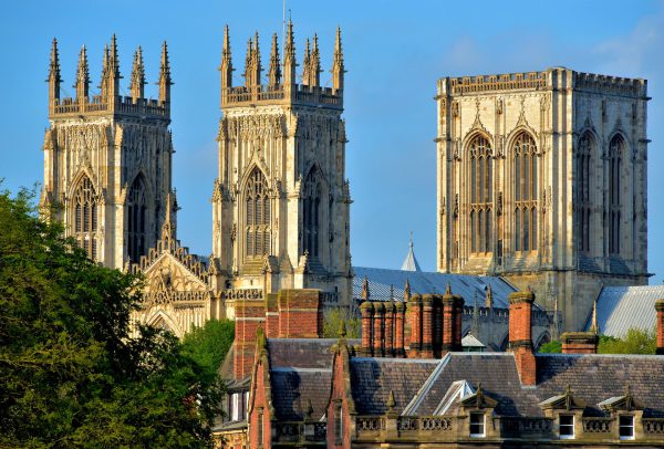
Eboracum began as a fort in the 1st century and grew to the largest city in Rome’s province of Britannia while witnessing the death and ascension of Roman emperors. It was conquered by the Angles, Vikings and Normans before being granted a city charter by Richard II in 1396. Henry VIII and Elizabeth I purged its treasures and destroyed Catholic churches and monasteries during the Reformation. The Luftwaffe bombed it from the air in 1942. Despite it all, York has evolved into a delightful modern city that takes pride in its medieval landmarks. This view of York from the Station Road Walls shows the three magnificent towers of York Minster. On the left are the Western Towers finished in 1472. On the right is the 235 foot Central Tower completed in 1415. Together they are the visual pinnacle of York.
Deangate, Minster Yd, York YO1 7HH, UK Enlarge/Slideshow See On Map Directions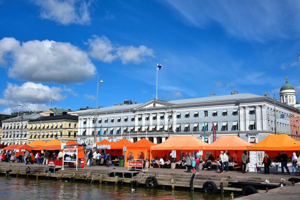
If you sail through the Baltic Sea into the Gulf of Finland and through the South Harbour, this will be your first view of Finland’s capitol city. Since Helsinki was founded in the mid-16th century, it has struggled with a devastating plague, foreign invasions, a civil war and the rule of Sweden and Russia. But since the country’s independence in 1917, Helsingfors have prospered and become the country’s largest metropolitan area with over one million people.
Port of Helsinki, 00170 Helsinki, Finland Enlarge/Slideshow See On Map Directions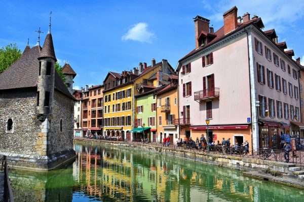
Annecy is a tourist town with about 50,000 residents in southeast France about 22 miles south of Geneva. It is nestled in a valley among four mountains at the northern end of Lac d’Annecy, a crystal-clear lake stretching over ten square miles. Annecy’s history can be traced back to 4th millennium BC and then the Romans in the 1st century BC. Several of the current buildings, many of which line the canals, were built in the Middle Ages. Annecy has been called the “Venice of Savoie” and the “Jewel of the French Alps.” You can call it charming.
Le Palais de I'lle 3 Passage de l'Île, 74000 Annecy, France Enlarge/Slideshow See On Map Directions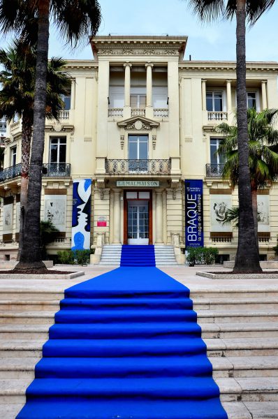
This building is all that remains of the prestigious Grand Hotel that was built in 1860. Today, the blue carpet welcomes you to La Malmaison, a contemporary art museum. It is located on the Boulevard de la Croisette. This is the main promenade along the waterfront beach that is lined with luxury hotels and stores. They cater to celebrities attending the annual Cannes Film Festival.
47 Boulevard de la Croisette, 06400 Cannes, France Enlarge/Slideshow See On Map Directions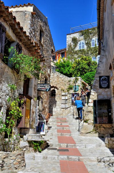
No cars are allowed in the tiny, perched village of Éze. The only entrance is through a 700 year old arched gate called Poterne. From there you wander up a labyrinth of cobbled walkways among galleries and perfume shops, restaurants with stunning views of the Mediterranean, gardens and the charming stone homes of the town’s 2,600 residents. Éze is a marvelous place to spend a few hours. As you trudge up the narrow passages, imagine always carrying everything you need up this steep hill.
1 Place du Planet, 06360 Èze, France Enlarge/Slideshow See On Map Directions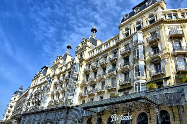
The Hôtel Excelsior Régina Palace was built in 1896 on Cimiez Hill in Nice to accommodate Queen Victoria’s annual visits to France known as her “French connection.” A statue of the United Kingdom’s longest reigning monarch is in the gardens nearby. This elegant building that reflects the prosperity of the Belle Époque period is now residential.
71 Bd de Cimiez, 06000 Nice, France Enlarge/Slideshow See On Map Directions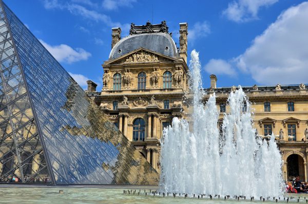
It is so exciting to be standing next to the Louvre Pyramid and Pavillon Richelieu in the Napoleon Courtyard of the Palais du Louvre. Formerly a palace, the museum opened in 1793. It now has a collection of over 35,000 pieces spread across 14 acres of space. The Musée du Louvre welcomes nearly ten million visitors a year. Most people want to catch a glimpse of its famous resident, Mona Lisa.
10 Place du Carrousel, 75001 Paris, France Enlarge/Slideshow See On Map Directions
Tourists often go to Saint-Ràphaël for the wonderful beaches without the high cost and crowds of several other, more famous towns along the Côte d’Azur. After you have had enough sun, stroll along this tree-lined promenade called Commandant Guilbaud and try to decide which of the fabulous restaurants you will select for dinner. Consider ordering fresh fish or, better yet, mussels in garlic butter. Your meal will be the perfect way to end your day.
14 Prom. Commandant Guilbaud, 83700 Saint-Raphaël, France Enlarge/Slideshow See On Map Directions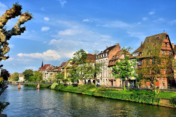
A quay is a pier alongside a body of water that is used to moor boats. Spelled “quai” in French, they often serve as a promenade like this vine-covered stone wall along the Ill River. Quays surround the Grande Ȋle which is an elliptical shaped island in Strasbourg, France. The entire Grand Island is a UNESCO World Heritage Site because the streets and buildings still reflect Strasbourg’s medieval history.
5 Quai Au Sable 67000 Strasbourg, France Enlarge/Slideshow See On Map Directions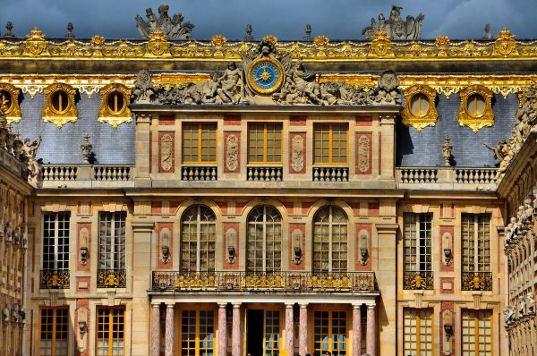
What started as a royal hunting lodge of Louis XIII in 1623 evolved into the magnificent Château de Versailles. The palace was the prized residence of French monarchs until 1789 when Louis XVI was forced to flee at the start of the French Revolution. This is the opulent Marble Courtyard. The square greets visitors with the promise of more grandeur behind the golden façade. In back of the palace are elaborate gardens and the petit appartement of Marie-Antoinette. This UNESCO World Heritage Site is definitely worth the train ride from Paris.
Cour de Marbre, 78000 Versailles, France Enlarge/Slideshow See On Map Directions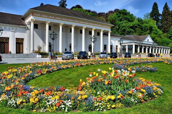
Since it was built in 1824, Kurhaus has hosted celebrities, royalty, dignitaries and members of high society with gala dinners, balls and concerts. Beneath glistening chandeliers in elegant rooms is an array of gambling options including French and American style roulette. If you prefer to keep your travel money in your pocket, then limited guided tours are available in the morning for only few euros.
Kaiserallee 1, 76530 Baden-Baden, Germany Enlarge/Slideshow See On Map Directions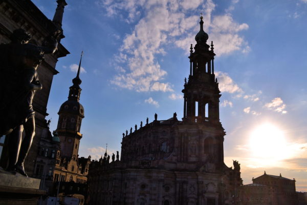
Wow! From the staircase leading up to Brühl’s Terrace, the setting sun paints a canvas of silhouettes worthy of any student from the Dresden Academy of Fine Arts. From left to right are: the Higher Regional Court of Dresden (Oberlandesgericht), the Noon Statue (one of the Four Times a Day sculptures), the Royal Palace tower (Hausmannsturm), the Cathedral of the Holy Trinity (Katholische Hofkirche) and the opera house (Semperoper). Spectacular!
Brühlsche Terrasse, 01067 Dresden, Germany Enlarge/Slideshow See On Map Directions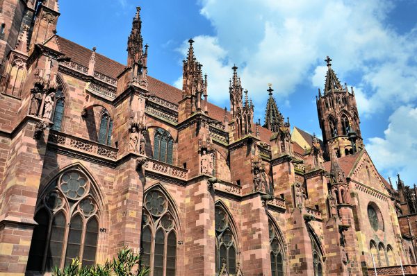
It took over 130 years to complete this Freiburg Minster cathedral. When it was being built from 1200 to 1330 was a period of architectural transition. That is why it began using a Romanesque style but finished using Gothic features such as large rose windows, buttresses and ornate towers and spires. You will also notice the statues and gargoyles.
Münsterplatz 10, 79098 Freiburg im Breisgau, Germany Enlarge/Slideshow See On Map Directions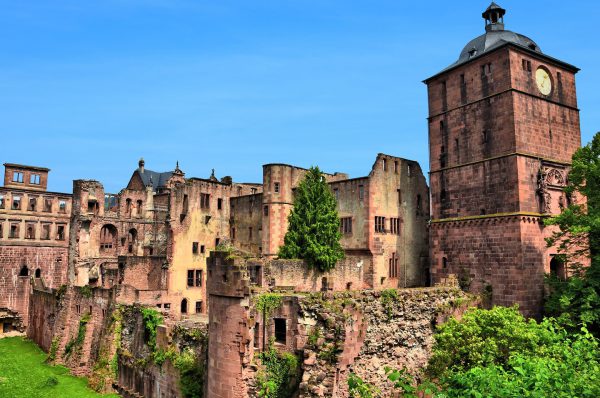
The magnificent Heidelberg Castle ruins stand majestically on a wooded hill named Königstuhl and nicknamed “The King’s Throne.” Starting in the early 13th century, this was the fortified palace of Palatine counts and later Prince Electors before being repeatedly destroyed during enemy attacks and a lightning strike. On the left is the Englischer Bau which was built in the 17th century. In the center is Prison Tower. On the right is the Gate Tower entrance.
Schlosshof 1a, 69117 Heidelberg, Germany Enlarge/Slideshow See On Map Directions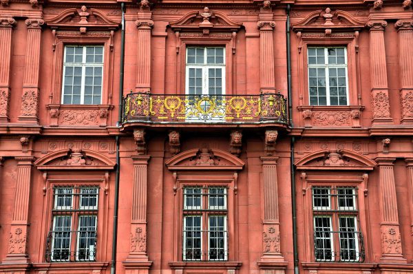
During the French Revolution in 1792, the French army occupied Mainz. The Germans tried to declare their independence by announcing the formation of the Republic of Mainz from this balcony. However, the French attacked 18 weeks later and imprisoned the republic’s leaders for treason. Two years later, the French seized the Deutschhaus and it was used as a palace by Napoléon Bonaparte.
Peter-Altmeier-Allee 9 55116 Mainz, Germany Enlarge/Slideshow See On Map Directions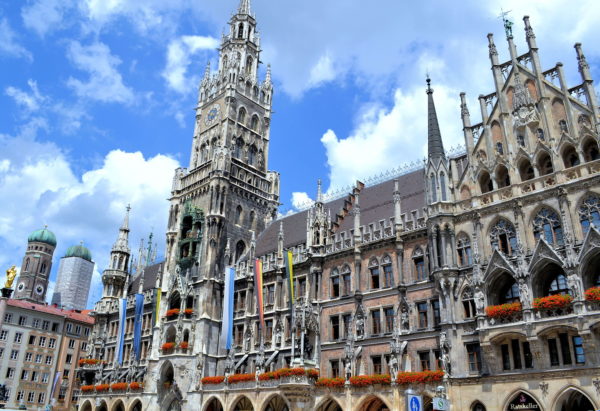
München is typically named among the top five most livable cities in Europe and the world. The 1.5 million residents can recite endless reasons for this distinction. Among the accolades are the quality of education, culture, business, employment, sports, technology, entertainment and beer. Tourists are equally thrilled while visiting Bavaria’s capital city, especially in Old Town (Altstadt). Start your exploration by admiring New Town Hall at St. Mary’s Square. Along the 328 foot, Gothic façade are statues of almost every Bavarian ruler from the House of Wittelsbach since the dynasty began in the 11th century. Wunderbar!
Marienplatz 8, 80331 München, Germany Enlarge/Slideshow See On Map Directions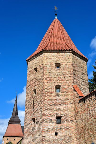
During the Middle Ages, Rostock was surrounded by stone walls. They averaged ten feet high and 3.5 feet thick. Outside the wall was a moat. Inside were platforms behind the battlements for soldiers to stand on during battle. Interspersed along the ramparts were six, octagon-shaped towers. The Busch tower is all that remains of the original defenses. It was reconstructed on the foundation of a previous tower in 1825. In the background is the spire of the Steintor gate.
Hinter der Mauer 1, 18055 Rostock, Germany Enlarge/Slideshow See On Map Directions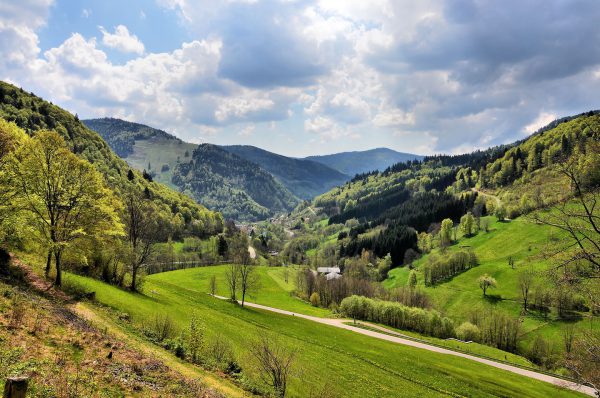
Driving through the Black Forest in the southwest corner of Germany is spectacular. You are treated to mountains covered by lush, green pines and firs, valleys containing quaint towns, farms with grazing cattle plus numerous rivers and glacier-created lakes. Do not speed through the Schwarzwald on the motorway. Take the slow, scenic routes so you can enjoy all of this natural beauty.
Talstraße 2, 79674 Todtnau, Germany Enlarge/Slideshow See On Map Directions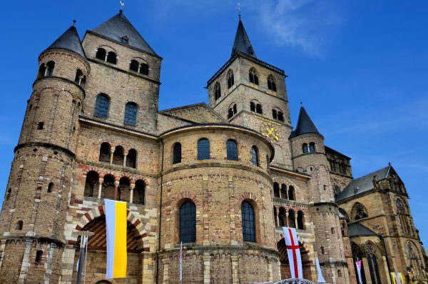
Hohe Domkirche St. Peter zu Trier was completed in 1270, making it Germany’s oldest Roman Catholic cathedral. The stone Romanesque façade of the Cathedral of Trier gives this UNESCO World Heritage Site the appearance of a medieval castle. Inside are the relics of Saint Helena. She was an empress, the mother of Constantine the Great, and the first Christian emperor of Rome. Helena claims to have discovered the True Cross of Christ’s crucifixion in 328 AD.
Liebfrauenstraße 1, 54290 Trier, Germany Enlarge/Slideshow See On Map Directions
This town of 8,500 people in northern Germany is called Warnemünde Seaside Resort. That is more than a moniker written for marketing brochures. The Badestrand or bathing beach has a width of nearly 500 feet that stretches for almost two miles along the Baltic coastline. So, take off your shoes. Then, let your toes enjoy the white sand and warm surf while you stroll along the beach with your partner. What a perfect way to spend a perfect afternoon.
Seepromenade 3, 18119 Rostock, Germany Enlarge/Slideshow See On Map Directions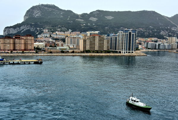
Gibraltar covers only 2.6 miles. Yet its position at the entry of the Mediterranean Sea – 15 miles by water from North Africa – has etched its place in history for over 50,000 years. Among the people who lived here are Neanderthals, Phoenicians, Romans, Visigoths, Moors and Spanish. Since 1713, it has been under British rule. Gibraltar is now mostly self-governed yet remains a British Overseas Territory. Its most famous geological feature is the Rock of Gibraltar, seen here from the west. This massive limestone promontory is two miles square with an elevation of almost 1,400 feet. At the base of The Rock is the delightful city of Gibraltar with 33,000 people. You will enjoy their hospitality while you explore the landmarks and fortifications that reflect their unique and proud history.
[36.121820, -5.340433] Enlarge/Slideshow See On Map Directions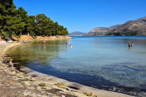
According to archeologists, people have probably swum in this crescent-shaped cove since Mycenaean Greece. That time period was part of the Bronze Age dating back to 1600 to 1100 BC. The island of Cephalonia (or Kefalonia) was named after Cephalus. He was a Greek mythical hero and the area’s first leader. Some experts also claim this was the Greek island called Ithaca from Homer’s Iliad and the Odyssey. Those epics were written around the 8th century BC.
Ellinikou Erithrou Stavrou 39 Argostoli 281 00, Greece Enlarge/Slideshow See On Map Directions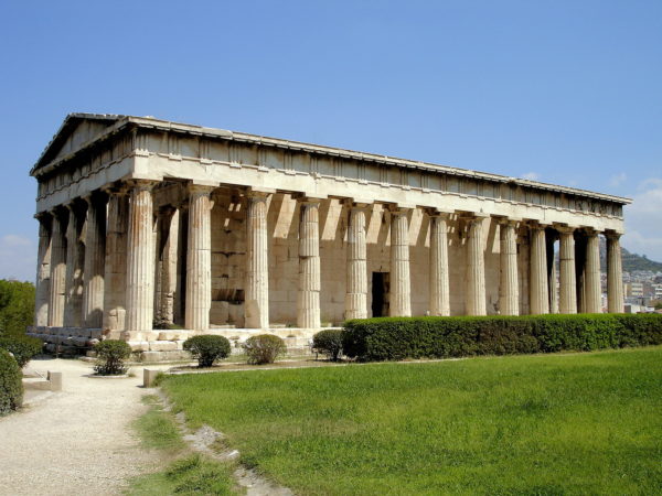
Your exploration of the Ancient Agora begins at the Temple of Hephaestus. It was finished in 415 BC after 34 years of construction. Unlike many of the archeological sites in Athens, this structure is largely intact. The project was initiated by Pericles (495 – 429 BC), a leader of the Athenian democracy. He sponsored numerous buildings during the 5th century BC including the Parthenon. This Golden Age of Athens is also called the Age of Pericles. The temple is dedicated to Hephaestus. The son of Zeus and Hera was the Greek god of craftsmen, artisans and sculptors. He was also the blacksmith to the gods on Mount Olympus. Among his many consorts was his wife Aphrodite. She was the Greek goddess of love and beauty. The temple served as the Orthodox Church of Saint George Akamates from the 7th century AD until 1834. The ancient structure was a museum until 1934.
Temple of Hephaestus, Ancient Agora, Athina 105 55, Greece Enlarge/Slideshow See On Map Directions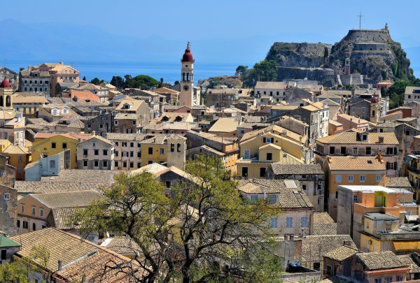
Starting in the 6th century and until the 13th century, Corfu residents lived within the walls of the fortified peninsula seen as the summit in the upper right corner. Over the centuries, this became more of a military fort. Therefore, the town of Koryfo grew up outside of the protective walls and in the valley between the Old Fortress and the New Fortress. In the foreground is the Old Quarter, a UNESCO World Heritage Site. The entire city of Corfu (Kerkyra in Greek) has about 30,000 people. The red dome in the center is the bell tower of Saint Spyridon Church.
Old British Barraks Dionisiou Solomou 20, Kerkira 491 00, Greece Enlarge/Slideshow See On Map Directions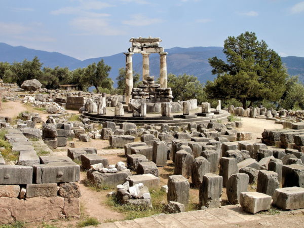
During much of the Archaic Period (800 – 479 BC), Delphi was highly revered, second only to Athens in importance. Greeks of all status made pilgrimages to this Panhellenic sanctuary. You are about to follow in their footsteps. Although the complex is in ruins, your imagination will quickly sense the former grandeur. You first encounter the Temple of Athena Pronaia. Athena was the Greek goddess of wisdom and warfare. She was also a protectress of several Greek cities including Athens (which took her name). The word Pronaia means “in front of.” This suggests she was protecting the larger temple in Delphi dedicated to her half-brother Apollo. The Athena site was composed of about nine structures including temples, treasuries and altars. The first temple was built in the 7th century BC and destroyed by an earthquake in the following century. The replacement was constructed in 510 BC. The third major temple was added in 360 BC.
Athena Pronaia Temple, Delphi 330 54, Greece Enlarge/Slideshow See On Map Directions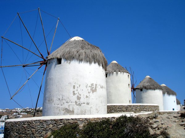
These five windmills on a seaside hill are the ionic symbol of the city and the island. During the 16th century, the Venetians were the first to harness the seasonal winds – the Sirocco in the winter and the Meltemi in the summer – to drive these mills for grinding grain. At one time, Mykonos was dotted with 28 windmills, especially along the western coastline. Now only a few remain. This row is called Kato Myloi meaning lower windmills.
Molinos de viento mikonos Mikonos 846 00, Greece Enlarge/Slideshow See On Map Directions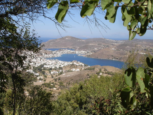
Archeologic evidence suggests this island was first populated over 5,000 years ago. According to Greek mythology, Artemis, the goddess of the hunt, convinced her father Zeus to raise the island from below the sea. It was then called Letois. Dorians lived here in the 5th and 4th centuries BC (Classical Period). Within a hundred years, the residents began building fortified walls. During the reign of Roman emperor Domitian (81 – 96 AD), political prisoners and social-dissidents were exiled here. John the Theologian was one of them. He arrived from Ephesus in 95 AD. After his death, Christianity took roots on the island until severely challenged by the Muslims in the 7th through 9th centuries. Patmos was largely uninhabited when it was given to Christodulus by emperor Alexios I Komnenos in 1088. Within a couple years, he and his monks were chased away. When his followers returned, they finished building the monastery. The population grew with war refugees from Constantinople (1453) and Candia (1669). For nearly 300 years, the island was successively controlled by the Ottomans, Venetians, Russians, Greeks, Italians and Nazis. After WWII, Patmos was independent until joining Greece in 1948.
Chora, Patmos 855 00, Greece Enlarge/Slideshow See On Map Directions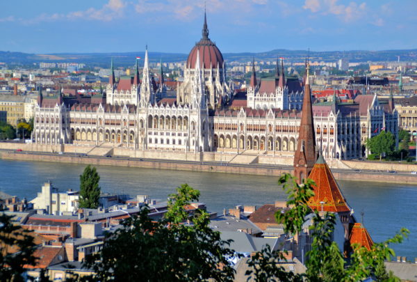
The architectural gem anchoring the East Bank of the Danube is the Hungarian Parliament Building in Pest. Architect Imre Steindl created this stunning Gothic Revival design. The house for the National Assembly of Hungary opened in 1896. This panoramic view is from the terrace of Fisherman’s Bastion on the Buda side. In the foreground is the Reformed Church. The tower of the Buda Calvinist Church stands 203 feet in sharp contrast to its pyramid-shaped roof covered with colorful Zsolnay tiles.
Budapest, Jezsuita lépcső 1, 1011 Hungary Enlarge/Slideshow See On Map Directions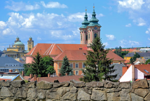
Hungary has a population of almost 10 million people; over 25% live in Budapest. Compared to the country’s capital city, Eger is small. Its 55,000 residents rank it the 19th city by size. That is also part of its charm. This gem in the northeast near the border of Slovakia offers fabulous architecture, cobblestone alleys, a lively town square, a millennium of fascinating history, a medieval castle plus some of Hungary’s best wine and food. This visual enticement shows the Minorite Church in the center and the Cathedral of Eger on the left.
Vár 10 Eger, 3300 Hungary Enlarge/Slideshow See On Map Directions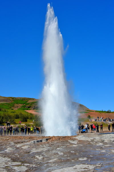
About every ten minutes and without warning, an impressive geyser called Strokkur hurdles a massive white plume into the air. This violent yet beautiful column of steam can reach a height above 100 feet before spraying the crowd of tourists as it collapses. “The Churn” was born and began erupting in 1789 after a local earthquake. Its performance was artificially enhanced in 1963 by enlarging the size of its basin.
35 & F333, Haukadalsvegur, Iceland Enlarge/Slideshow See On Map Directions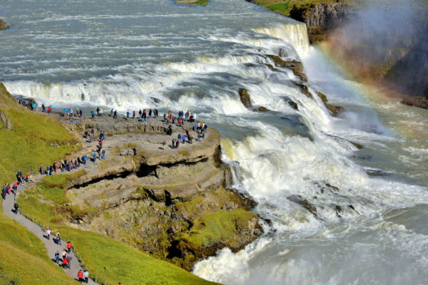
The descent of Gullfoss begins in two stages. The first drop is 36 feet followed immediately by a 69 foot plunge. The people huddled along the observation deck put the enormous Golden Waterfall into perspective. You are more impressed when you learn 4,900 cubic feet of water cascade over these edges every second during the summer months.
Gullfoss, 801 Selfossi, Iceland Enlarge/Slideshow See On Map Directions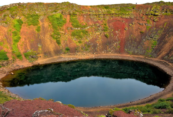
Your last stop on the Golden Circle is Kerið. This cone volcano erupted in 3500 BC. After cooling, the dome collapsed into the empty magna reservoir and then filled with water. The red-rock cavity measures 885 feet across and is 180 feet deep. Kerid is surrounded by 21 square miles of lava fields named Grímsneshraun. This marvelous crater lake is worth the small admission price. Kerið is located less than ten miles north of Selfoss on Highway 35 in the Western Volcanic Zone.
35 & Vaðnesvegur, Iceland Enlarge/Slideshow See On Map Directions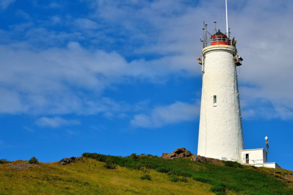
There are about 120 lighthouses along Iceland’s 3,088 mile coastline. The country’s first was built in 1878 on nearby Valahnúkur Point. After it was destroyed by an earthquake, this replacement was raised on Bæjarfell Hill. The concrete, cylindrical tower of the Reykjanes Lighthouse is capped with a red lantern. Together they stand 102 feet yet are 226 above sea level. Ships sailing in the North Atlantic can see the beacon up to 22 nautical miles before reaching the southwest coast of Iceland.
Reykjanes Lighthouse, Islandij, Reykjanes, Iceland Enlarge/Slideshow See On Map Directions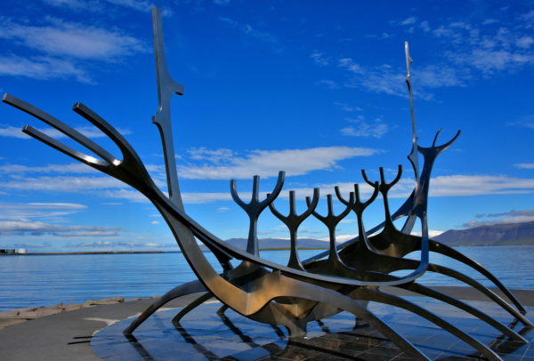
While walking along the Sæbraut coastal road, the abstract outline of a Viking ship grabs your attention. The Sun Voyager was created in 1990 by Jón Gunnar Arnason. He claims the stainless-steel sculpture represents a dreamboat of ancient navigators who followed the sun to discover new worlds. Yet its Icelandic name of Sólfar means Viking Funeral.
Skúlagata & Vatnsstígur, 101 Reykjavík, Iceland Enlarge/Slideshow See On Map Directions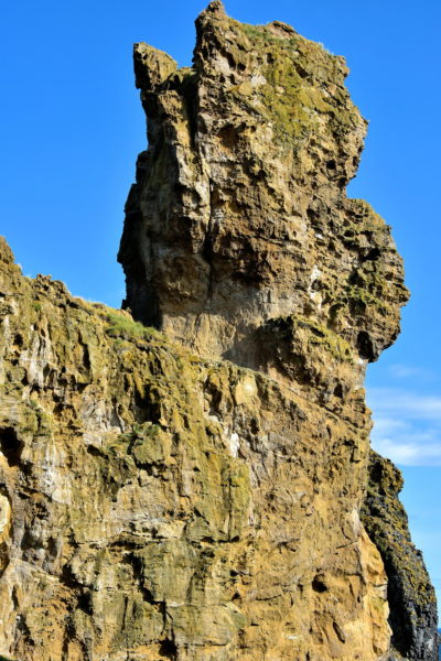
The Book of Settlement, also called Landnámabók, is a medieval document describing Norse life in Iceland during the 9th and 10th centuries. Within its pages is the story of when Laugarbrekku-Einar observed a troll sitting on top of this tallest basalt pillar at Lóndrangar. From this angle, it does look like a horse. The next person to reach the summit was climber Ásgrímur Böðvarsson in 1735.
Lóndrangar, Iceland Enlarge/Slideshow See On Map Directions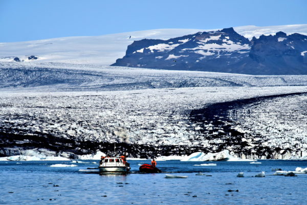
Two types of tours are available to experience the thrill of Jökulsárlón. Most tourists opt for an amphibious boat. Passengers embark onto a flat deck surrounded by bench seats. Then the vehicle drives into the lagoon and floats among the icebergs for about 40 minutes. Adventurous people sign up for a Zodiac tour. These are lightweight and fast inflatable boats. They skim across the water and travel further into the glacier lake until reaching the terminus. It is thrilling to watch calving icebergs as they break free from the glacier, splash into the water, twist and turn and sparkle brightly.
Jökulsárlón, Iceland Enlarge/Slideshow See On Map Directions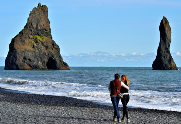
Black lava pebbles crunch beneath your feet as you stroll along Reynisfjara Beach to admire the pair of sea stacks. These are called Reynisdrangar. The tallest needle towers 217 feet. According to folklore, they are petrified trolls who turned to stone when caught beaching a boat at sunrise. Other stories tell of a monster living in the cave. You will only notice colonies of seabirds. The rolling surf might seem romantic and calm. Just do not venture too close and remain vigilant. They can suddenly become “sneaker waves.” These are violent surges of water capable of sweeping unsuspecting people into the frigid sea.
Reynishverfisvegur, Iceland Enlarge/Slideshow See On Map Directions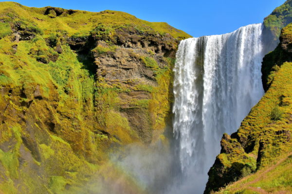
Skógafoss is constantly shrouded in swirling clouds of mist. On sunny days, you are guaranteed to see an arching rainbow and often a double. If you have always wanted to discover a pot of gold at the end of a rainbow, then Skógafoss is the place to look. According to folklore, an early settler named Þrasi Þórólfsson buried treasure here circa 900 AD. One man found it during the 17th century. However, when he tried to extract it, the handle came off in his hand and the chest disappeared. The legendary ring is on display at nearby Skógar Museum.
Skógafoss, Skogar, 861 South Iceland Enlarge/Slideshow See On Map Directions