Utah is blessed with five national parks, the third most of any state. Among the Mighty Five, Arches National Park is a wonderland of red sandstone formations. Here are the highlights of your drive along Arches Scenic Drive.
Utah is blessed with five national parks, the third most of any state. Among the Mighty Five, Arches National Park is a wonderland of red sandstone formations. Here are the highlights of your drive along Arches Scenic Drive.
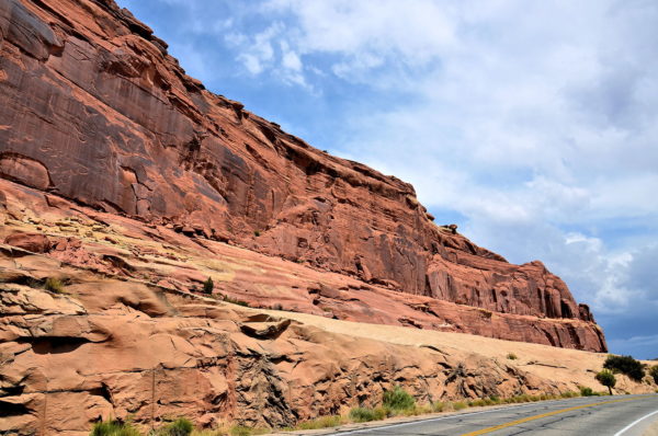
After passing through Moab, Utah and crossing the Colorado River, you are about five miles from Arches National Park. As you drive along U.S. Route 191, notice the walls of rock on either side of your car windows. The valley you are traveling through is the Moab Fault. The 28 mile geological fracture was caused when the earth’s crust cracked about six million years ago. The mammoth displacement caused the ridgeline on your left (west) to be 2,600 feet taller than on your right (east). The best view of the Moab Fault can be seen at the first turnout inside the park.
UT-191 & UT-279, UT-279, Moab, UT 84532 Enlarge/Slideshow See On Map Directions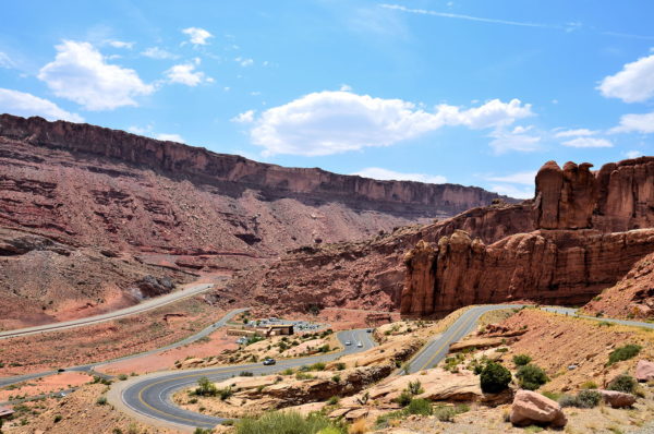
Nearly 1.7 million people get excited each year as they take this winding road toward Arches Visitor Center. Inside are maps, exhibits, a bookstore and helpful rangers. They can answer your questions and suggest ways to create a memorable experience. The national park is open every day except Christmas from 8:00 until 5:00. To avoid the crowds, plan on arriving before 9:00 or after 2:00. The peak season is from April through October. During the summer, you must contend with lots of traffic, limited parking at stops, throngs of photo-taking tourists and average high temperatures of 100° F. Your adventure begins at an elevation of 4,085 feet. After leaving the Arches Visitor Center parking lot, you start driving uphill.
Arches Entrance Rd, Moab, UT 84532 Enlarge/Slideshow See On Map Directions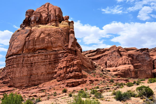
Arches is one of the Mighty Five, a collection of outstanding national parks in southern Utah. The other four are Bryce Canyon, Canyonlands, Capital Reef and Zion. It is easy to understand how the park was named. There are over 2,000 sandstone arches within these 76,679 acres of red-rock country. You will also admire abundant mesas, needles, monoliths and natural bridges. This geological masterpiece has been a work in progress for over 300 million years. To preserve this visual sensation for future generations, Arches was made a national monument in 1929 and a national park in 1971.
Arches Scenic Dr, Moab, UT 84532 Enlarge/Slideshow See On Map Directions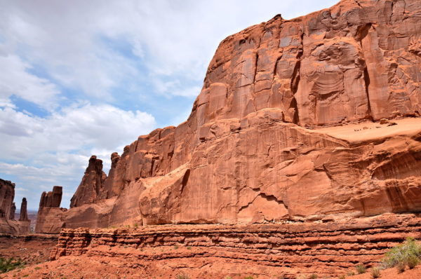
During your excursion through Arches National Park, you will travel on Arches Scenic Drive. The two-lane road is about 22 miles one way or 45 miles round trip. You should plan on a minimum of four to five hours to stop at the highlights, wait for a place to park each time and take a few photos near the road before hopping back in the car. Better yet, reserve seven to eight hours if you want to savor the views and walk along a few of the trails. Unfortunately, there are no shuttle services in the park so this will be a self-guided tour. This travel guide describes many of the favorite sites such as Park Avenue shown here.
Park Avenue Viewpoint, Arches Scenic Dr, Moab, UT 84532 Enlarge/Slideshow See On Map Directions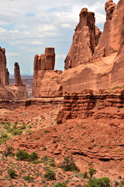
About 2.5 miles from the Arches Visitor Center is the first major overlook. The stunning panorama is named after a famous street in Manhattan: Park Avenue. It is easy to see why. The sheer red cliffs are crowned with soaring fins resembling New York City skyscrapers. On the far left is Argon Tower. Rising 270 feet, this rock column is equivalent to a 27 story high-rise. To the immediate right is The Candelabrum.
Park Avenue Viewpoint, Arches Scenic Dr, Moab, UT 84532 Enlarge/Slideshow See On Map Directions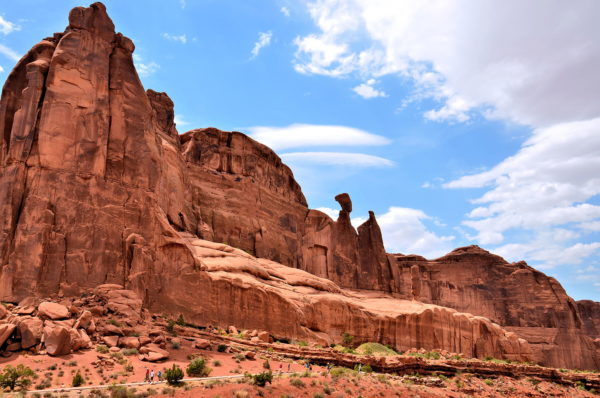
Most popular sites in the geological park are visible from Arches Scenic Drive or a short distance from the parking lots along the way. Each stopping point also tends to be a trailhead. Park Avenue is a good example of both options. The viewing platform is only 320 feet from your car. Extend your pleasure by strolling along the easy-to-moderate Park Avenue Trail. The paved path winds downhill through a canyon between colossal monoliths for just under a mile. If you want to avoid the two-mile round trip, ask a traveling companion to drive your car to Courthouse Towers Viewpoint about a mile away on Arches Scenic Drive.
Park Avenue Viewpoint, Arches Scenic Dr, Moab, UT 84532 Enlarge/Slideshow See On Map Directions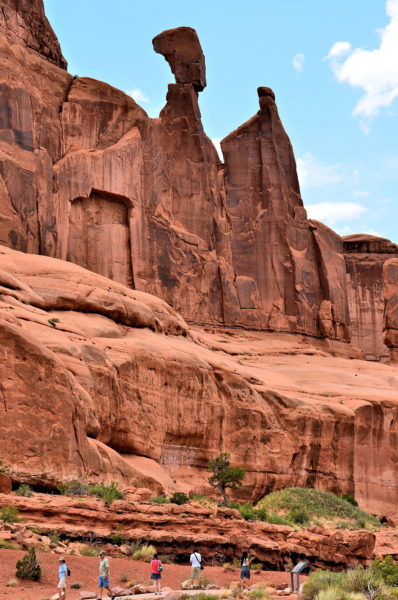
If you enjoyed identifying shapes in clouds as a kid, then your fertile imagination will work overtime when staring at rock formations in Arches. Over forty of them have been given diverse and often whimsical names such as Barney Rubble Tower, Three Penguins, The Wishbone, Cuddlebunny Tower and Bullwinkle Tower. One of the most famous is Queen Nefertiti Rock on the western wall of Park Avenue. The balancing rock resembles the crowned bust of Egypt’s most famous queen sculpted in 1340 BC.
Park Avenue Viewpoint, Arches Scenic Dr, Moab, UT 84532 Enlarge/Slideshow See On Map Directions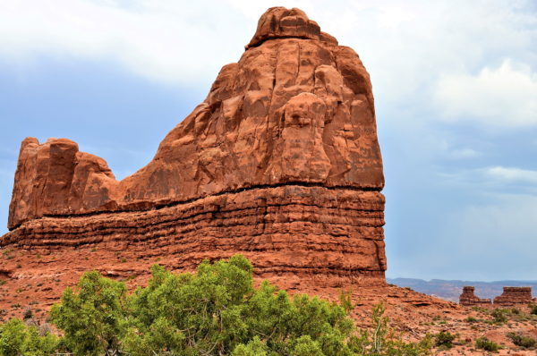
La Sal Mountains Viewpoint is your second stop in Arches National Park at 3.4 miles from the visitor center. The elevated vantage point provides a 360° appreciation for the monoliths you are about to encounter, the surrounding Petrified Sand Dunes and the La Sal Mountains located 20 miles south of Moab. The 12,721 foot summit is often snow-capped. The name means Salt Mountains. Closest to your car is the 215 foot high Mars Hotel.
La Sal Mountains Viewpoint, Arches Scenic Dr, Moab, UT 84532 Enlarge/Slideshow See On Map Directions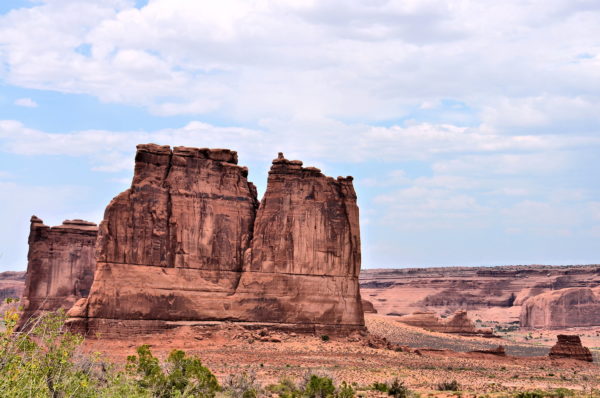
Two impressive sandstone fins are observable from La Sal Mountains Viewpoint. Each of them is about 435 feet tall. The double-butte in the foreground is The Organ. North of it (on the left) is the Tower of Babel. The namesake is the mythical structure that reached toward heaven as described in the Book of Genesis from the Old Testament.
La Sal Mountains Viewpoint, Arches Scenic Dr, Moab, UT 84532 Enlarge/Slideshow See On Map Directions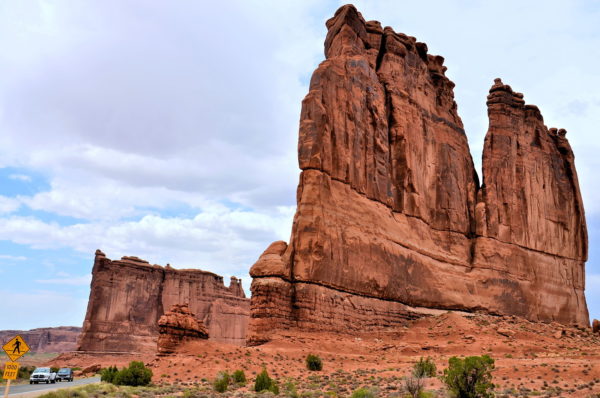
How were the stunning formations at Arches National Park created? That is a very long story. 300 million years ago, this area was underwater. As the sea evaporated, it left behind a salt bed measuring over a thousand feet deep named the Paradox Formation. Layers of debris piled on. 200 million years ago, the region (called the Colorado Plateau) became a desert and gathered more sediment similar to a layer cake. By the next 50 million years, the sedimentary rock reached a depth of 5,000 feet. All of this weight caused the underlying salt to liquefy, shift upwards and create domes while faulting the Entrada Sandstone. During subsequent millenniums, wind, rain and ice plus dramatic shifts in daily temperature chipped away at the exposed salt and weaker rock. The erosion resulted in tall, narrow walls of hard rock called fins. Two examples are The Organ (right) and the Tower of Babel (left). At times, these massive formations were softer in the middle. The forces of nature sculpted these fragile centers into the park’s famous arches.
The Organ, Arches Scenic Dr, Moab, UT 84532 Enlarge/Slideshow See On Map Directions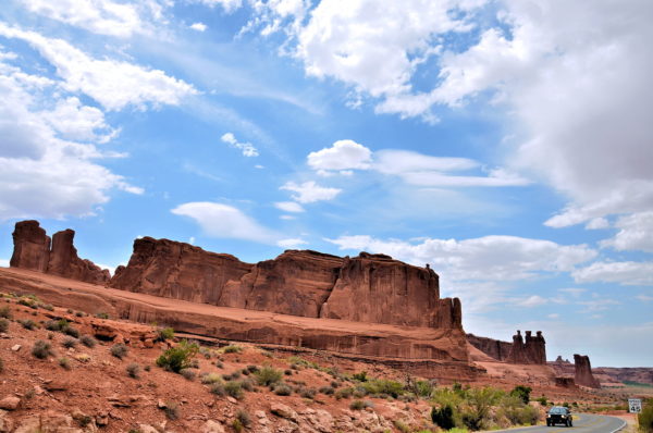
After leaving La Sal Mountains Viewpoint, an enormous mesa appears outside of the driver’s side window (west). If you previously walked along Park Avenue Trail, you already have an appreciation for the bold beauty of Courthouse Towers. The salmon-colored sandstone has multiple spires that reach up to 600 feet.
The Organ, Arches Scenic Dr, Moab, UT 84532 Enlarge/Slideshow See On Map Directions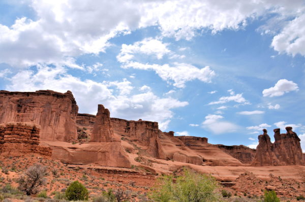
The third major turnout at Arches is at the base of The Organ rock formation about 4.3 miles from the park entrance. Your eyes will immediately gravitate across the road toward the trio of sandstone towers. These are the Three Gossips. They stand about 350 feet tall. Their flat, almost equal summits peak at an elevation of about 4,700 feet.
Courthouse Towers Viewpoint, Arches Scenic Dr, Moab, UT 84532 Enlarge/Slideshow See On Map Directions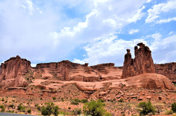
If you volunteered to pick up family or friends who walked the .9 miles of the Park Avenue Trail, your rendezvous point is at Courthouse Towers Parking Lot. By the time they finish their trek, you have become very accustomed to this view of the Three Gossips. When they arrive, they will first want something cold to drink. Then, they will go on and on about the great scenery you missed and share every photo they took. That’s gratitude for you.
Courthouse Towers Viewpoint, Arches Scenic Dr, Moab, UT 84532 Enlarge/Slideshow See On Map Directions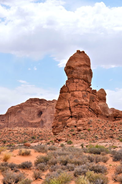
Within a mile of leaving Courthouse Towers Viewpoint, you will encounter the Tower of Babel (435 feet tall on your right), Sheep Rock (320 feet tall on your left) and cross over a meandering stream through a canyon named Courthouse Wash. Almost immediately, you will drive between the Petrified Dunes (east) and The Great Wall (west). At the north end of the giant sandstone cliff are a series of impressive pinnacles. Several of them have names such as The Lovers (120 feet) shown here.
The Great Wall, Arches Scenic Dr, Moab, UT 84532 Enlarge/Slideshow See On Map Directions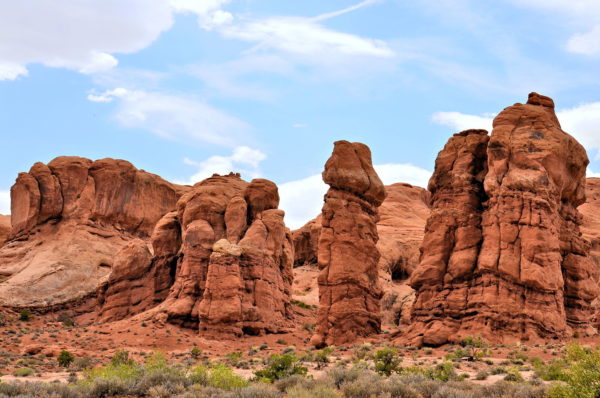
Another named pinnacle you will encounter at the base of The Great Wall is The Phallus (80 feet tall) and nearby is The Poodle (160 feet tall). Equally interesting are the numerous shallow caves in the rockface. They are on the evolutionary path toward becoming arches in the very distant future.
Rock Pinnacles, Arches Scenic Dr, Moab, UT 84532 Enlarge/Slideshow See On Map Directions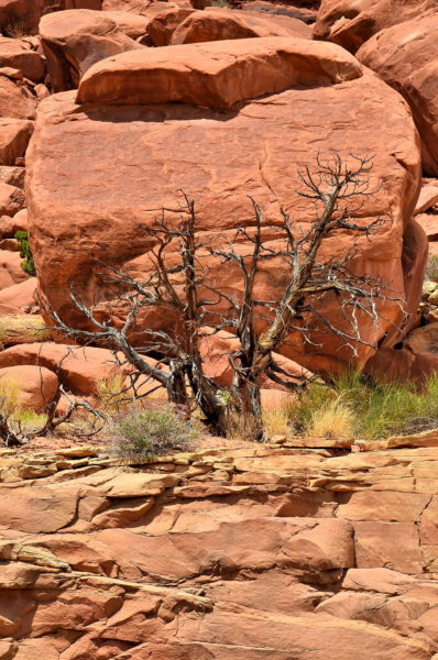
Arches National Park has annual rainfall of less than nine inches with fewer than six inches of snow. This low precipitation, together with an elevation above 5,000 feet and very hot summers, have created a high-desert ecosystem. Shrubs are the dominant vegetation, including blackbrush, four-wing saltbrush and cliffrose. Two tree species have also adapted to the harsh environment. Pinyons have reddish bark, crooked trunks and can survive up to 200 years. Utah junipers like this one often appear dead. In reality, the plant stops sending moisture to its extremities during dry periods. The park’s rocky landscape also hosts about 50 animal species. Chances are you might spot a desert cottontail, a mule deer or some of the eleven types of mice and rats. Consider yourself very lucky if you see a red fox, desert bighorn sheep or a mountain lion.
Arches Scenic Dr, Moab, UT 84532 Enlarge/Slideshow See On Map Directions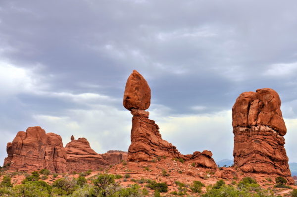
One of the most recognizable formations at Arches National Park is the Balanced Rock. The seemingly gravity-defying phenomenon appears shortly after nine miles on Arches Scenic Drive. You can gawk at the 128 foot tall oddity from the parking lot. Or get a closer look by walking a .3 mile loop trail. The statistics are staggering. The Entrada Sandstone on top is 55 feet tall and weighs 3,577 tons! The pedestal is composed of a softer Dewey Bridge mudstone and continues to erode. Someday, the giant boulder will come crashing down. A similar fate occurred to the sibling formation – Chip Off the Old Block – during the winter of 1975/76.
Balanced Rock Trailhead, Arches Scenic Dr, Moab, UT 84532 Enlarge/Slideshow See On Map Directions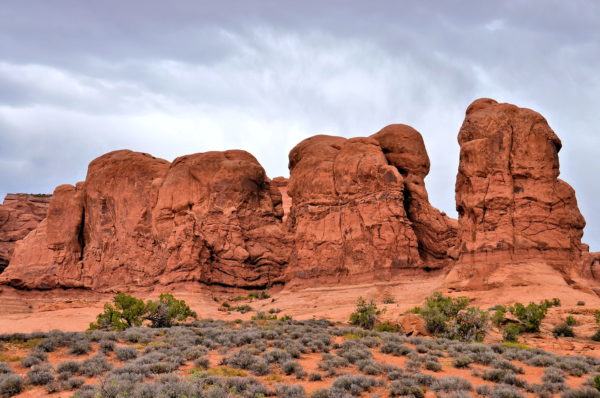
After leaving the Balanced Rock parking lot, watch for an almost immediate right turn onto Windows Road. You will soon see a sign reading, “Garden of Eden Viewpoint.” This parcel is ideal for those with extra time. The compact area features reddish monoliths accented with tall pinnacles. Many of these hoodoos have clever names such as Adam and Eve, Devil’s Golf Ball and Owl Rock. There is no trail through the Garden of Eden. But it is easy and fun to meander for 30 to 45 minutes.
Garden of Eden, Windows Road, Arches Scenic Dr, Moab, UT 84532 Enlarge/Slideshow See On Map Directions
The Windows Section is on most people’s shortlist when visiting Arches. There are two places to park at the end of Windows Road. The upper parking lot marks the Double Arch Trailhead. As you begin your easy .6 mile round trip stroll, the Parade of Elephants are there to greet you (pictured). Often overlooked are the pinyon and juniper clutching to the red topsoil. These scruffy-looking shrubs look dead. But a similar photo from the National Park achieves taken in 1925 shows this hearty groundcover has changed little in 100 years. Now look up. In the background (right) is Elephant Butte. The 5,653 foot peak is the highest elevation in Arches National Park.
Double Arch Trailhead, Windows Road, Arches Scenic Dr, Moab, UT 84532 Enlarge/Slideshow See On Map Directions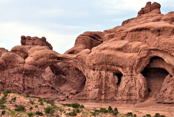
Double Arch Trail ends at its namesake geological attraction: The Double Arch. The larger of these two arches is gargantuan. It measures 112 feet tall (the highest in Arches) and 144 feet wide. The smaller arch is still huge at 86 feet tall and 67 feet wide. You will feel infinitesimal when standing beneath these Siamese twins.
Double Arch, Windows Road, Arches Scenic Dr, Moab, UT 84532 Enlarge/Slideshow See On Map Directions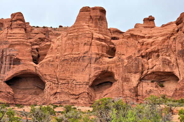
Most tourists at Arches stick to defined trails. A few curious people seek out paths less traveled. The Cove of Caves is one such opportunity. Find it by walking beneath the Double Arch or the saddle (space between two hills) to the left of the Double Arch. Think of these caves as future arches in the maternity ward. There are also faint petroglyphs in this area. Several examples of ancient rock carvings have been uncovered in the Moab region. Some of them are attributed to the Paleo-Indians. These nomadic hunter/gatherers traveled through today’s southern Utah over 10,000 years ago at the end of the Ice Age. Their primary prey were now-extinct bison, camels and mammoths.
Cove of Caves, Windows Road, Arches Scenic Dr, Moab, UT 84532 Enlarge/Slideshow See On Map Directions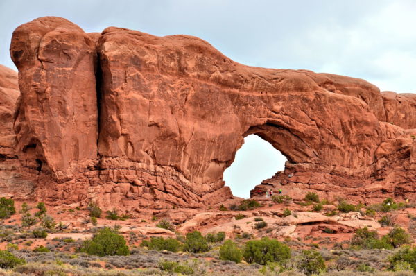
At the lower parking lot of the Windows Section is another scenic adventure worthy of your time. The Windows Trail is a one-mile loop. The first highlight is the North Window Arch (shown here). The dimensions are 48 feet high and 90 feet wide. The South Window (off camera to the right) is slightly larger. It measures 54 feet tall and 115 feet across. Separating them is a 100 foot wide fin (wall of rock). Hence, these twin arches are often called The Spectacles. Don’t leave before also admiring the nearby Turret Arch.
North Windows, Windows Road, Arches Scenic Dr, Moab, UT 84532 Enlarge/Slideshow See On Map Directions
The Delicate Arch is the consistent favorite in Arches National Park. To find it after visiting the Windows Section, return to Arches Scenic Drive, travel north for about 2.5 miles and turn right on Delicate Arch Road. You can appreciate the iconic span from a mile away at either the Upper or Lower Delicate Arch Viewpoints. Or, trudge 1.5 miles uphill (three miles total) to get a closer look at this freestanding arch measuring 46 feet high and 32 feet wide. The advantage of this option is stopping at Wolfe Ranch. In 1898, John Wesley Wolfe settled here at the age of 69. The modest log house is called Turnbow Cabin. There are a few additional sites north of Delicate Arch worth mentioning. They are Landscape Arch (park’s widest arch at 290 feet) and the Dark Angel stone obelisk in Devil’s Garden, the Fiery Furnace and the Double O Arch. Or, you can start your half hour drive back to the visitor center about 14 miles away.
Lower Delicate Arch Viewpoint, Delicate Arch Rd, Moab, UT 84532 Enlarge/Slideshow See On Map Directions